
Mount Everest is Earth's highest mountain above sea level, located in the Mahalangur Himal sub-range of the Himalayas. The China–Nepal border runs across its summit point. Its elevation of 8,848.86 m was most recently established in 2020 by the Chinese and Nepali authorities.

Porter Mountain is one of the Adirondack High Peaks. It is number 38 in order of height, and one of the easier hikes of the Adirondack Forty-Sixers. It is named after Noah Porter, one of the first to climb it, later president of Yale University.

On 8 September 2000, following a three-day Millennium Summit of world leaders gathered in New York at the headquarters of the United Nations, the UN General Assembly adopted some 60 goals regarding peace; development; environment; human rights; the vulnerable, hungry, and poor; Africa; and the United Nations which is called Millennium Declaration . A follow-up outcome of the resolution was passed by the General Assembly on 14 December 2000 to guide its implementation. Progress on implementation of the Declaration was reviewed at the 2005 World Summit of leaders. The Declaration includes 8 chapters and 32 paragraphs.

Husband Hill is one of the Columbia Hills in Gusev crater, Mars, which are close to the landing site of NASA's Spirit rover. It was named in honor of Rick Husband, the commander of the Space Shuttle Columbia when it disintegrated upon atmospheric reentry.

Iroquois Peak is the eighth-highest peak in the Adirondack Mountains in New York State, U.S., and is part of the MacIntyre Range, which also includes Wright Peak, Mount Marshall, and Algonquin Peak. Although the mountain does not have an officially maintained trail, a well-maintained "herd path" leads to the summit from the northeast.

Summit Lake Provincial Park is a Class C provincial park located southeast of the community of Summit Lake in the Central Kootenay region of British Columbia, Canada.
Rounds Mountain, 2,257 feet (688 m), is a prominent peak in the Taconic Mountains of western Massachusetts and adjacent New York. The west side of the mountain and summit are located in New York; the east side is located within Massachusetts. The summit a bald; the slopes are wooded with northern hardwood tree species. It is notable for its views of the Hudson River Valley to the west and the Green River and Kinderhook Creek valleys of Hancock, Massachusetts to the east. The 35 mi (56 km) Taconic Crest Trail traverses the mountain. Much of the upper slopes and summit are within protected conservation land.
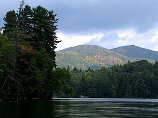
Saint Regis Mountain is a 2,838-foot-tall (865 m) mountain in the town of Santa Clara, New York, in Franklin County at the center of the Saint Regis Canoe Area in the Adirondack Park.

Mount Julian is a mountain summit in the northern Front Range of the Rocky Mountains of North America. The 12,933-foot (3,942 m) peak is located in the Rocky Mountain National Park Wilderness, 12.2 miles (19.7 km) west of the Town of Estes Park in Larimer County, Colorado, United States. The mountain was named in honor of Julian Hayden, a civil engineer who lived in Estes Park.
For the mountain in California formerly named Summit Peak, see Mount Ina Coolbrith.

Taylor Peak, elevation 13,158 ft (4,011 m), is a summit in the Front Range of north central Colorado. The peak is in Rocky Mountain National Park at the head of Loch Vale and just north of Taylor Glacier.
Dollarhide Mountain, at 9,301 feet (2,835 m) above sea level is a peak in the Smoky Mountains of Idaho. The peak is located in Sawtooth National Forest on the border of Blaine and Camas counties. It is located about 4.2 mi (6.8 km) south of Baker Peak. Forest road 227 travels near the peak over a road pass known as Dollarhide Summit. No roads or trails go to the summit.
Waugh Mountain, elevation 11,716 ft (3,571 m), is a summit in Fremont County, Colorado.

Ptarmigan Peak is the highest summit of the South Williams Fork Mountains range in the Rocky Mountains of North America. The peak is north of Dillon, CO in the White River National Forest.
Mount Emmons is a mountain summit in the Elk Mountains range of the Rocky Mountains in north-central Gunnison County, Colorado, United States.
Bitch Mountain is a summit in Essex County, New York, in the United States. With an elevation of 2,625 feet (800 m), Bitch Mountain is the 527th highest summit in the state of New York.

Mount Neva is a summit in Grand County, Colorado, in the United States. With an elevation of 12,849 feet (3,916 m), Mount Neva is the 752nd-highest summit in the state of Colorado.
Kanhaya Lal Pokhriyal is an Indian Police official and mountaineer, known for climbing the highest peak in the world, Mount Everest, in 1992. He was born on 10 January 1949 at the small village of Sachkhil in the Pauri Garhwal district of the Indian state of Uttarakhand and has served the Indo-Tibetan Border Police. He is the only Indian mountaineer to have climbed Kanchenjunga through two routes, from Sikkim and Nepal.

Mohan Singh Gunjyal is an Indian mountaineer and adventure sportsman. He is one of the summiters of Mount Everest, entering the list when he successfully climbed the highest peak in the world on 12 May 1992. He achieved the feat, taking the Southeast ridge route via the south face, as a member of the Indo-Tibetan Border Police Everest expedition group, which included Santosh Yadav, the first woman to summit the peak twice within a year. He has received the Tenzing Norgay National Award for outstanding achievement from the President of India in 2004. He is a former Assistant Commandant of Indo-Tibetan Border Police and presently working as Director at the Uttarkashi-based Nanda Devi Institute of Adventure Sports and Outdoor Education. The Government of India awarded him with Tenzing Norgay National Adventure Award 2004 in lifetime achievement category and the fourth highest civilian honor of the Padma Shri, in 2006, for his contributions to the sport of mountaineering.

Nenzinger Himmel is the local name given to a collection of seasonal high-alpine settlements in the Gamperdonatal valley near the market town of Nenzing in the Austrian state of Vorarlberg. These include four alpine shielings with attached cheeseries, the valley's only Gasthaus and a number of privately owned mountain huts, often used as summer resorts.


