Description
The region represents a portion of a large foredeep (Carpathian Foredeep) that formed during the Miocene epoch in front of the folding Carpathian Mountains. The outer zone of the foredeep has as its foundation the Podolian Platform; the inner zone consists of severely dislocated flysch deposits. The foredeep itself is filled with thick Miocene deposits of clays, argillites, calcareous clays, and sandstones covered by diluvial and alluvial deposits.

The Carpathian Mountains or Carpathians are a mountain range system forming an arc roughly 1,500 km (932 mi) long across Central and Eastern Europe, making them the third-longest mountain range in Europe after the Ural Mountains with 2,500 km (1,553 mi) and Scandinavian Mountains with 1,700 km (1,056 mi).

Flysch is a sequence of sedimentary rock layers that progress from deep-water and turbidity flow deposits to shallow-water shales and sandstones. It is deposited when a deep basin forms rapidly on the continental side of a mountain building episode. Examples are found near the North American Cordillera, the Alps, the Pyrenees and the Carpathians.
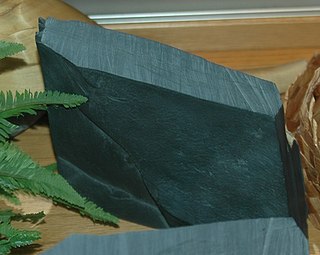
Argillite is a fine-grained sedimentary rock composed predominantly of indurated clay particles. Argillaceous rocks are basically lithified muds and oozes. They contain variable amounts of silt-sized particles. The argillites grade into shale when the fissile layering typical of shale is developed. Another name for poorly lithified argillites is mudstone. These rocks, although variable in composition, are typically high in aluminium and silica with variable alkali and alkaline earth cations. The term pelitic or pelite is often applied to these sediments and rocks. Metamorphism of argillites produces slate, phyllite, and pelitic schist.
At the end of the Pliocene epoch the region was an accumulative-denudational peneplain covered by fluvial deposits of sand, silt, and clay originating from the Carpathians. As a result of an uplift at the end of the Pliocene and the beginning of the Pleistocene epoch the rivers intensified their erosion and sculpted into the surface a number of wide valleys, lowlands, and intervening ridges.

In geomorphology and geology a peneplain is a low-relief plain formed by protracted erosion. This is the definition in the broadest of terms, albeit with frequency the usage of peneplain is meant to imply the representation of a near-final stage of fluvial erosion during times of extended tectonic stability. Peneplains are sometimes associated with the cycle of erosion theory of William Morris Davis, but Davis and other workers have also used the term in a purely descriptive manner without any theory or particular genesis attached.
Silt is granular material of a size between sand and clay, whose mineral origin is quartz and feldspar. Silt may occur as a soil or as sediment mixed in suspension with water and soil in a body of water such as a river. It may also exist as soil deposited at the bottom of a water body, like mudflows from landslides. Silt has a moderate specific area with a typically non-sticky, plastic feel. Silt usually has a floury feel when dry, and a slippery feel when wet. Silt can be visually observed with a hand lens, exhibiting a sparkly appearance. It also can be felt by the tongue as granular when placed on the front teeth.
The uplift of Eastern Carpathian Foothills was not uniform, however, and the relief features are partly of tectonic origin. In the Dnieper glacial phase the northeastern part of Eastern Carpathian Foothills was occupied by a lobe of the European continental glacier, and the meltwaters temporarily ponded. By the end of the Pleistocene epoch the region was covered by deposits of loess. At present the rivers from the Carpathian Mountains, most notably the Stryi River, carry silt and sand on to Eastern Carpathian Foothills and deposit them in their floodplains.

Loess is a clastic, predominantly silt-sized sediment that is formed by the accumulation of wind-blown dust. 10% of the Earth's land area is covered by loess or similar deposits.

The Stryi River starts in the Carpathian mountains in western Ukraine. It snakes through the mountains running for 144 miles (231 km). After 120 miles it passes Stryi. The river continues for another 20 miles before joining the Dniester near Khodoriv.

The geography of Ukraine varies greatly from one region of the country to another, with the majority of the country lying within the East European Plain. Ukraine is the second-largest country by area in Europe. Its various regions have diverse geographic features ranging from highlands to lowlands, as well as climatic range and a wide variety in hydrography.

Ivano-Frankivsk Oblast is an oblast (region) in western Ukraine. Its administrative center is the city of Ivano-Frankivsk. As is the case with most other oblasts of Ukraine this region has the same name as its administrative center – which was renamed by the Soviet Ukrainian authorities after the Ukrainian writer Ivan Franko on November 9, 1962. Population: 1,382,352 (2016 est.).
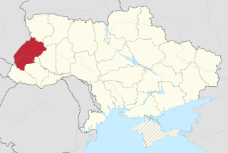
Lviv Oblast is an oblast (province) in western Ukraine. The administrative center of the oblast is the city of Lviv. Population: 2,534,174 (2016 est.).

The Los Angeles Basin is a sedimentary basin located in southern California, in a region known as the Peninsular Ranges. The basin is also connected to an anomalous group of east-west trending chains of mountains collectively known as the California Transverse Ranges. The present basin is a coastal lowland area, whose floor is marked by elongate low ridges and groups of hills that is located on the edge of the Pacific plate. The Los Angeles Basin, along with the Santa Barbara Channel, the Ventura Basin, the San Fernando Valley, and the San Gabriel Basin, lies within the greater southern California region. On the north, northeast, and east, the lowland basin is bound by the Santa Monica Mountains and Puente, Elysian, Repetto hills. To the southeast, the basin is bordered by the Santa Ana mountains and the San Joaquin Hills. The western boundary of the basin is marked by the Continental Borderland and is part of the onshore portion. The California borderland is characterized by north-west trending offshore ridges and basins. The Los Angeles Basin is notable for its great structural relief and complexity in relation to its geologic youth and small size for its prolific oil production. Yerkes et al. identify 5 major stages of the basin's evolution that begins in the Upper Cretaceous and ends in the Pleistocene. This basin can be classified as an irregular pull-apart basin accompanied by rotational tectonics during the post-early Miocene.
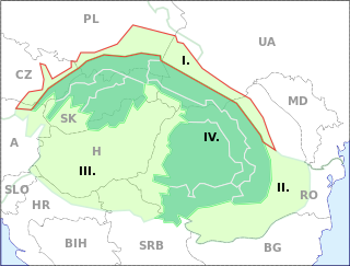
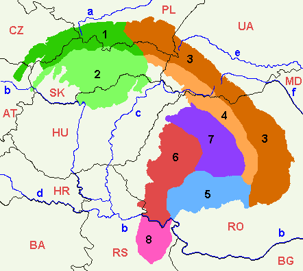
Outer Subcarpathia denotes the depression area at the outer base of the Carpathian arc, including foothills of the Outer Western Carpathians and Outer Eastern Carpathians. It stretches from northeastern Austria, trough eastern Czech Republic, southern Poland, western Ukraine and northeastern Romania. The opposite foothill regions on the inner side of the Carpathian arc are known as Inner Subcarpathia, transitioning further to the Pannonian Basin.
The East European Plain is a vast interior plain extending east of the North/Central European Plain, and comprising several plateaus stretching roughly from 25 degrees longitude eastward. It includes the westernmost Volhynian-Podolian Upland, the Central Russian Upland, and on the eastern border, encompasses the Volga Upland. The plain includes also a series of major river basins such as the Dnepr Basin, the Oka-Don Lowland, and the Volga Basin. Along the southernmost point of the East European Plain are the Caucasus and Crimean mountain ranges. Together with the North European Plain, and covering the Baltics, Moldova, south-eastern Romania, and its most southern expansion - the Danubian Plain in Northern Bulgaria, it constitutes the European Plain, the greatest mountain-free part of the European landscape.

The Pannonian Basin, or Carpathian Basin, is a large basin in Central Europe. The geomorphological term Pannonian Plain is more widely used for roughly the same region though with a somewhat different sense, with only the lowlands, the plain that remained when the Pliocene Epoch Pannonian Sea dried out.

Orography of Azerbaijan refers to the rocky, mountainous and elevated terrains in Azerbaijan. The tectonic structure is typical for the orography of the country. The main morphostructural units are the Greater Caucasus, the Lesser Caucasus, the Gusar plane, the Samur-Devechi lowland, the Kur intermountain trough, the Karabagh volcanic highland, the near and middle Araz Ridges and Talysh Mountains.

The Paratethys ocean, Paratethys sea or just Paratethys was a large shallow inland sea that stretched from the region north of the Alps over Central Europe to the Aral Sea in Central Asia. The sea was formed during the Oxfordian stage of the Late Jurassic as an extension of the rift that formed the Central Atlantic Ocean and was isolated during the Oligocene epoch. It was separated from the Tethys Ocean to the south by the formation of the Alps, Carpathians, Dinarides, Taurus and Elburz mountains. During its long existence the Paratethys was at times reconnected with the Tethys or its successors, the Mediterranean Sea or Indian Ocean. From the Pliocene epoch onward, the Paratethys became progressively shallower. Today's Black Sea, Caspian Sea, Aral Sea, Lake Urmia, Namak Lake and others are remnants of the Paratethys Sea.

The Geology of Bangladesh is affected by the country's location, as Bangladesh is mainly a riverine country. It is the eastern two-thirds of the Ganges and Brahmaputra river delta plain stretching to the north from the Bay of Bengal. There are two small areas of slightly higher land in the north-centre and north-west composed of old alluvium called the Madhupur Tract and the Barind Tract, and steep, folded, hill ranges of older (Tertiary) rocks along the eastern border.
The Hanau-Seligenstadt Basin is a subbasin of the Upper Rhine Graben southeast of Frankfurt am Main.

The Murray Basin is a Cenozoic sedimentary basin in south eastern Australia. The basin is only shallow, but extends into New South Wales, Victoria and South Australia. It takes its name from the Murray River which traverses the Basin from east to west.
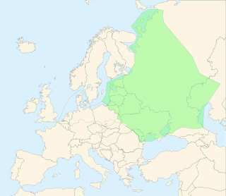
Sian Lowland or Oversian basin is a lowland located at the border between Poland and Ukraine along the San River. Most of the region is located in Poland except for a small portion in southeastern end which is in Ukraine.

The Columbus Basin is a foreland basin located off the south eastern coast of Trinidad within the East Venezuela Basin (EVB). Due to the intensive deformation occurring along the Caribbean and South American plates in this region, the basin has a unique structural and stratigraphic relationship. The Columbus Basin has been a prime area for hydrocarbon exploration and production as its structures, sediments and burial history provide ideal conditions for generation and storage of hydrocarbon reserves. The Columbus Basin serves as a depocenter for the Orinoco River delta, where it is infilled with 15 km of fluvio-deltaic sediment. The area has also been extensively deformed by series of north west to southeast normal faults and northeast to southwest trending anticline structures.

The geology of Sicily records the collision of the Eurasian and the African plates during westward-dipping subduction of the African slab since late Oligocene. Major tectonic units are the Hyblean foreland, the Gela foredeep, the Apenninic-Maghrebian orogen, and the Calabrian Arc. The orogen represents a fold-thrust belt that folds Mesozoic carbonates, while a major volcanic unit is found in an eastern portion of the island. The collision of Africa and Eurasia is a retreating subduction system, such that the descending Africa is falling away from Eurasia, and Eurasia extends and fills the space as the African plate falls into the mantle, resulting in volcanic activity in Sicily and the formation of Tyrrhenian slab to the north.
The geology of Ukraine is the regional study of rocks, minerals, tectonics, natural resources and groundwater in the country. The oldest rocks in the region are part of the Ukrainian Shield and formed more than 2.5 billion years ago in the Archean eon of the Precambrian. Extensive tectonic evolution and numerous orogeny mountain building events fractured the crust into numerous block, horsts, grabens and depressions and Ukraine was intermittently flooded as the crust downwarped during much of the Paleozoic, Mesozoic and early Cenozoic, before the formation of the Alps and Carpathians defined much of its current topography and tectonics. Ukraine was impacted by the Pleistocene glaciations within the last several hundred thousand years. The country has numerous metal deposits as well as minerals, building stone and high-quality industrial sands.
The geology of Kazakhstan includes extensive basement rocks from the Precambrian and widespread Paleozoic rocks, as well as sediments formed in rift basins during the Mesozoic.
The geology of Slovakia is structurally complex, with a highly varied array of mountain ranges and belts largely formed during the Paleozoic through the Cenozoic.

The Geology of Italy includes mountain ranges such as the Alps, the Dolomites and the Apennines formed from the uplift of igneous and primarily marine sedimentary rocks all formed since the Paleozoic.. Some active volcanoes are located in Insular Italy.