This article includes a list of references, related reading, or external links, but its sources remain unclear because it lacks inline citations .(December 2023) |
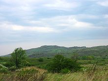
Azov Upland is a plateau or range of hills in East Ukraine within the Donetsk and Zaporizhia oblasts.
To the north it borders Dnieper Lowland, to northeast – Donets Ridge, southwest – Black Sea Lowland, south – Azov Lowland. Elevation varies between 200–250 m (660–820 ft).
Interesting features are mounds locally known as mohyly similar to Russian equivalent of kurgan. The highest hill is Belmak-Mohyla (Horyla) that rises at 327 m (1,073 ft).
The climate is similar to Donets Ridge. Soils are categorized as chernozem of poor or medium humus. Vegetation is a fescue-feather-grass steppe.
Ukraine is the second-largest European country, after Russia. Its various regions have diverse geographic features ranging from highlands to lowlands, as well as climatic range and a wide variety in hydrography. Most of the country lies within the East European Plain.
The Appalachian Mountains, often called the Appalachians, are a mountain range in eastern to northeastern North America. Here, the term "Appalachian" refers to several different regions associated with the mountain range, and its surrounding terrain. The general definition used is one followed by the United States Geological Survey and the Geological Survey of Canada to describe the respective countries' physiographic regions. The U.S. uses the term Appalachian Highlands and Canada uses the term Appalachian Uplands; the Appalachian Mountains are not synonymous with the Appalachian Plateau, which is one of the provinces of the Appalachian Highlands.
The Seversky Donets or Siverskyi Donets, usually simply called the Donets, is a river on the south of the East European Plain. It originates in the Central Russian Upland, north of Belgorod, flows south-east through Ukraine and then again through Russia to join the river Don, about 100 km (62 mi) from the Sea of Azov. The Donets is the fourth-longest river in Ukraine, and the largest in eastern Ukraine, where it is an important source of fresh water. It gives its name to the Donets Basin, known commonly as the Donbas, an important coal-mining and industrial region in Ukraine.
The East European Plain is a vast interior plain extending east of the North European Plain, and comprising several plateaus stretching roughly from 25 degrees longitude eastward. It includes Volhynian-Podolian Upland on its westernmost fringe, the Central Russian Upland, and, on the eastern border, encompasses the Volga Upland. The plain includes also a series of major river basins such as the Dnepr Basin, the Oka–Don Lowland, and the Volga Basin. At the southeastern point of the East European Plain are the Caucasus and Crimean mountain ranges. Together with the North European Plain, and covering the Baltic states, European Russia, Belarus, Ukraine, Moldova, southeastern Romania, and, at its southernmost point, the Danubian Plain in Northern Bulgaria, it constitutes the majority of the Great European Plain, the greatest mountain-free part of the European landscape. The plain spans approximately 4,000,000 km2 (2,000,000 sq mi) and averages about 170 m (560 ft) in elevation. The highest point of the plain, located in the Valdai Hills, is 346.9 metres (1,138.1 ft).
The Central Russian Upland is an upland area of the East European Plain and is an undulating plateau with an average elevation of 230–250 m (750–820 ft). Its highest peak is measured at 293 m (961 ft). The southeastern portion of the upland known as the Kalach Upland. The Central Upland is built of Precambrian deposits of the crystalline Voronezh Massif.
The Kazakh Uplands, also known as the Kazakh Hummocks, is a large peneplain formation extending throughout the central and eastern regions of Kazakhstan.
The Port of Mariupol or Mariupol Sea Port is located in Mariupol, Ukraine in the Taganrog Bay, Sea of Azov. The port is governed by the port authority managed by Ukrainian Sea Ports Authority. As of June 2022, it is occupied by Russian armed forces.
The North German Plain or Northern Lowland is one of the major geographical regions of Germany. It is the German part of the North European Plain. The region is bounded by the coasts of the North Sea and the Baltic Sea to the north, Germany's Central Uplands to the south, by the Netherlands to the west and Poland to the east.
The Podolian Upland or Podillia Upland is a highland area in southwestern Ukraine, on the left (northeast) bank of the Dniester River, with small portions in its western extent stretching into eastern Poland.
The Timan Ridge is a highland in the far north of European Russia. Most of the Timan Ridge is situated in the Komi Republic, but the northernmost part is in Nenets Autonomous Okrug and Arkhangelsk Oblast. The highest point in the Timan Ridge is Chetlassky Kamen.
Novorossiya Governorate was an administrative-territorial unit (guberniya) of the Russian Empire, which existed in 1764–1783 and again in 1796–1802. It was created and governed according to the "Plan for the Colonization of New Russia Governorate" issued by the Russian Senate. It became the first region in Russia where Catherine the Great allowed foreign Jews to settle.
The Dnieper Upland or Cisdnieper Upland is a southeastern European plain occupying the territory between the Dnieper and the Southern Bug. It lies in central Ukraine, occupying the oblasts of Zhytomyr, Kyiv, Vinnytsia, Cherkasy, Kirovohrad and Dnipropetrovsk.
Pryazovia or literally Cis-Azov region is usually used to refer to the geographic area of the north coast of the Sea of Azov. It is located in the southern part of the Azov-Kuban Lowland within the East European Plain, which surrounds the Sea of Azov for most of the stretch of coastline. In a more general sense it may mean the Azov Sea littoral, and conversely, to be more specific, it may also be referred to as the Northern Priazovye.
The Black Sea Lowland is a major geographic feature of the Northern Pontic region and the East European Plain. It is almost completely within Southern Ukraine covering half of its territory.
Eastern Carpathian Foothills as a geographical term designates transitional region in the western parts of Ukraine and northeastern parts of Romania, between Eastern Carpathian Mountains to the southwest and number of plain regions to the east and north. Its average elevation is around 300–500 m (980–1,640 ft) above sea level. The region stretches across Lviv, Ivano-Frankivsk and Chernivtsi Oblasts and Suceava County.
Savur-Mohyla, often transliterated using the Russian spelling Saur-Mogila, is a strategic height in the Donets ridge near the city of Snizhne, in Donetsk Oblast, Ukraine.
The Donets Ridge is a highland that is the highest north-eastern part of the Donets upland. The ridge is in the Donetsk and Luhansk Oblasts of Ukraine and partially in the Rostov Oblast of Russia. The highest point on the ridge is a hill — Mohyla Mechetna, 367 m (1,204 ft).
Dnieper Lowland is a major geographic feature of the Central Ukraine region and the East European Plain.
The Volhynian Upland is an upland in western Ukraine, with its small northwestern part stretching into eastern Poland.
47°19′53″N36°34′45″E / 47.3315°N 36.5791°E