Podunavlje

Last updated

Podunavlje is the name of the Danube river basin parts located in Croatia (Slavonia, Syrmia, and Baranya) and Serbia (Vojvodina, Belgrade and Eastern Serbia). Podunavlje is located on the southern edge of Pannonian Basin. In its wider meaning, the Croatian term refers to the area around the entire flow of the river Danube. [1]

Contents

Naming history

In the first half of the 18th century, Sava-Danube (Posavina-Podunavlje) section of the Habsburg Military Frontier existed in the area. Podunavlje segment of the Frontier comprised parts of southern Bačka and northern Syrmia including towns of Petrovaradin, Šid, Bačka Palanka, Bački Petrovac, Petrovaradinski Šanac (Novi Sad), and Titel.

Danube Banovina map Danube banovina.png
Danube Banovina map

Between 1922 and 1929, Podunavlje Oblast was one of the administrative units of the Kingdom of Serbs, Croats and Slovenes. It included parts of Šumadija and Banat regions and its seat was in Smederevo. Between 1929 and 1941, one of the provinces of the Kingdom of Yugoslavia was known as the Danube Banovina. The province consisted of the geographical regions of Syrmia, Bačka, Banat, Baranya, Šumadija, and Braničevo. The capital city of the Danube Banovina was Novi Sad. In 1941, the World War II Axis Powers occupied the province. Bačka and Baranya regions were attached to Miklós Horthy's Hungary, while Syrmia was attached to the Independent State of Croatia. The remaining rump Danube Banovina (including Banat, Šumadija, and Braničevo) existed as part of German-occupied Serbia until the end of 1941 with its capital at Smederevo. Today, Smederevo is seat of the Podunavlje District of Serbia.

Between 1980 and 1989, Podunavlje was a name of one of the former seven municipalities of Novi Sad City in Serbia.

Eastern Slavonia, Baranya and Western Syrmia (1991–1998), the eastern portion of the Republic of Serbian Krajina, was sometimes called 'Podunavska Krajina' by Serbs or 'Croatian Podunavlje' by Croats.

Cities and towns in Podunavlje

List of cities and towns located on the river Danube in Podunavlje.

Cities and towns in Serbia: [2]

City / townStatusLocationPopulation (2011)
Apatin center of municipality Vojvodina 17,352
Bačka Palanka center of municipality Vojvodina 27,924
Beočin center of municipality Vojvodina 7,800
Futog town Vojvodina 18,269
Veternik suburban settlement Vojvodina 16,895
Novi Sad the capital of
Vojvodina
Vojvodina 221,854
Sremska Kamenica town Vojvodina 11,967
Petrovaradin center of municipality Vojvodina 14,298
Sremski Karlovci center of municipality Vojvodina 8,722
Zemun
(part of Belgrade)
center of municipality Belgrade 151,811
Belgrade
(including Zemun)
the capital of
Serbia
Belgrade 1,135,502
Pančevo the center of
South Banat District
Vojvodina 73,992
Smederevo the center of
Podunavlje District
Southern and Eastern Serbia 63,028
Kovin center of municipality Vojvodina 13,499
Kostolac center of municipality Southern and Eastern Serbia 9,264
Veliko Gradište center of municipality Southern and Eastern Serbia 5,868
Kladovo center of municipality Southern and Eastern Serbia 8,913

Cities and towns in Croatia: [3]

City / townStatusLocationPopulation (2011)
Beli Manastir [4] town Osijek-Baranja County 10,068
Vukovar city, center of
Vukovar-Srijem County
Vukovar-Syrmia County 27,683
Ilok town Vukovar-Syrmia County 6,767

Municipalities in Podunavlje

List of municipal areas connected to the river Danube in Podunavlje.

Municipalities in Serbia: [2]

Municipality / CityLocationPopulation (2011)
City of Sombor Vojvodina 85,569
Municipality of Apatin Vojvodina 28,654
Municipality of Odžaci Vojvodina 30,196
Municipality of Bač Vojvodina 14,150
Municipality of Bačka Palanka Vojvodina 55,361
Municipality of Bački Petrovac Vojvodina 13,302
Municipality of Beočin Vojvodina 15,630
City of Novi Sad
*Urban municipality of Novi Sad
*Urban municipality of Petrovaradin
Vojvodina 335,701
301,968
33,733
Municipality of Sremski Karlovci Vojvodina 8,722
Municipality of Inđija Vojvodina 47,204
Municipality of Titel Vojvodina 15,554
City of Zrenjanin Vojvodina 122,714
Municipality of Stara Pazova Vojvodina 65,508
City of Belgrade
*Municipality of Zemun
*Municipality of Palilula
*Municipality of Stari Grad
*Municipality of Grocka
Belgrade 1,639,121
166,292
170,593
48,061
83,398
City of Pančevo Vojvodina 122,252
City of Smederevo Southern and Eastern Serbia 107,528
Municipality of Kovin Vojvodina 33,725
City of Požarevac
*Urban municipality of Požarevac
*Urban municipality of Kostolac
Southern and Eastern Serbia 74,070
60,466
13,604
Municipality of Bela Crkva Vojvodina 17,285
Municipality of Veliko Gradište Southern and Eastern Serbia 17,559
Municipality of Golubac Southern and Eastern Serbia 8,161
Municipality of Majdanpek Southern and Eastern Serbia 18,179
Municipality of Kladovo Southern and Eastern Serbia 20,635
Municipality of Negotin Southern and Eastern Serbia 36,879

Municipalities in Croatia: [5]

Municipality / CityLocationPopulation (2001 or 2011)
Municipality of Bilje Osijek-Baranja County 5,480
Municipality of Borovo Vukovar-Syrmia County 5,360
Municipality of Bogdanovci [4] Vukovar-Syrmia County 1,960
Municipality of Markušica [4] Vukovar-Syrmia County 2,576
Municipality of Negoslavci [4] Vukovar-Syrmia County 1.463
Municipality of Nuštar [4] Vukovar-Syrmia County 3,639
Municipality of Stari Jankovci [4] Vukovar-Syrmia County 1,769
Municipality of Tordinci [4] Vukovar-Syrmia County 2.032
Municipality of Tovarnik [4] Vukovar-Srijem County 2,775
Municipality of Trpinja [4] Vukovar-Syrmia County 5,572
Municipality of Draž Osijek-Baranja County 3,356
Municipality of Erdut Osijek-Baranja County 8,417
Municipality of Kneževi Vinogradi Osijek-Baranja County 5,186
Municipality of Šodolovci [4] Osijek-Baranja County 1,653
Municipality of Petlovac [4] Osijek-Baranja County 2,405
Municipality of Popovac [4] Osijek-Baranja County 2,084
Municipality of Čeminac [4] Osijek-Baranja County 2,856
Municipality of Darda [4] Osijek-Baranja County 7,062
Municipality of Lovas Vukovar-Syrmia County 1,579

Podunavlje in Serbia

Geography and demographics

Northern part of Serbian Podunavlje is mostly flat, while southern part is mostly mountainous. Important rivers in Serbian Podunavlje that flowing into Danube are Tisa, Sava, Tamiš, and Morava. Two largest cities of Serbia, Belgrade and Novi Sad, are located in Podunavlje. Podunavlje includes parts of several traditional geographical regions in Serbia. Such are Bačka, Banat, Syrmia, Šumadija, Braničevo, and the Timok Valley.

Serbian Podunavlje is mainly populated by Serbs, while other smaller ethnic groups in the area are Slovaks, Hungarians, Croats, Rusyns, Romanians and Vlachs, Roma people, etc. Slovaks forming the majority of population in the municipality of Bački Petrovac, which is located near the Danube, in Bačka. Main religion in the area is Orthodox Christianity, while other smaller religious groups are Catholic Christians, Protestant Christians and Muslims.

History

Podunavlje region in Serbia was an area where several important prehistoric cultures flourished, notably the Lepenski Vir culture, the Starčevo culture, the Vinča culture, the Kostolac culture, the Vatin culture, the Belegiš culture, etc. It was also a core of the Tribal State of Celtic Scordisci, which had its capital in Singidunum (present-day Belgrade). Serbian Podunavlje was also a border region of Roman Empire and there are archaeological remnants of Roman civilization in the area.

In the Migration Period and the Middle Ages, the region was part of the Eastern Roman Empire, the Hunnic Empire, the Ostrogothic Kingdom, the Kingdom of the Gepids, the Lombard State, the Avar Khaganate, the Frankish Empire, the Bulgarian Empire, the Principality of Lower Pannonia, the Great Moravia, and the Kingdom of Hungary.

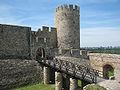
Although, Serbo-Croatian speaking South Slavs settled in Serbian Podunavlje in the 6th century, Serbian state did not reach the river Danube before the 13th century. Kingdom of Syrmia ruled by Serb king Stefan Dragutin (1284–1316) included southern Podunavlje and had its capitals in Debrc and Belgrade. The southern Podunavlje was subsequently included into other medieval Serbian states, notably the Serbian Empire, the Moravian Serbia and the Serbian Despotate. The Serbian Despotate had its capitals in Podunavlje, notably in Belgrade and Smederevo. After the Ottoman conquest of Serbian Despotate in 1459, Serbian statehood was temporarily restored in northern Podunavlje (in present-day Vojvodina) between 1526 and 1530, during the reigns of emperor Jovan Nenad and duke Radoslav Čelnik.

In the 16th century, the whole region was included into the Ottoman Empire. Subsequently, it became an area disputed between the Ottoman Empire and the Habsburg monarchy. After the Treaty of Belgrade from 1739 which defined the Habsburg-Ottoman border in Podunavlje, the region, as well as the local Serb people, became divided between the two empires. In both these areas, Serb people fought for their autonomy and independence. After the First and Second Serbian Uprising (in 1804 and 1815), an autonomous Ottoman Principality of Serbia was created in the south, while after the Serbian Uprising in Vojvodina (in 1848–1849), an autonomous Austrian Voivodeship of Serbia and Banat of Temeschwar was created in the north. The two autonomous areas, however, did not have the same fate; while the northern voivodeship was abolished in 1860, the southern principality gained full independence in 1878 and was transformed into the Kingdom of Serbia in 1882. In 1918, after the Habsburg defeat in the First World War, the northern Podunavlje was also included into the Kingdom of Serbia, which subsequently became part of the Kingdom of Serbs, Croats and Slovenes (later renamed to Yugoslavia). Since 2006, the whole region is part of an independent Republic of Serbia.

Podunavlje in Croatia

Geography and demographics

Podunavlje in Croatia Eastern Croatia map.png
Podunavlje in Croatia

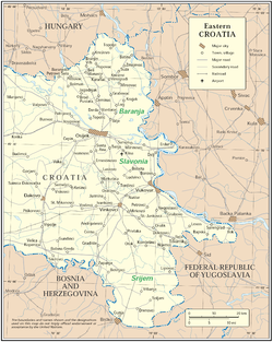
In Croatia, region is elongated in a north–south along the Danube which is border river between Croatia and Serbia. On the north region bordering with Hungary and on west continues to Slavonia, Syrmia and Baranya and rest of Croatia. The region is extremely flat with an average altitude of 80–110 meters. Coendures of Croatian Podunavlje are approximately overlapping with the territory of pre-War territory of Yugoslav municipalities Beli Manastir, Osijek, Vinkovci and Vukovar. [4] Those four municipalities had a territory of 3.436 kilometres and constituted 6,1% of territory of Socialist Republic of Croatia. In 1991 mentioned municipalities had 402.152 inhabitants living in 157 settlements and they constituted 8,4% of population of Croatia at the time. [4] After the collapse of Yugoslavia, local government system in Croatia was significantly changed and today Croatian Podunavlje in widest sense can be described as a region that is overlapping with the territory of Vukovar-Syrmia and Osijek-Baranja counties. [4] In this sense region include the gravitation regions of towns of Našice and Županja and is significantly bigger and cover the area of 6.597 kilometres or 11,7% of territory of Croatia with 348 settlements and 598.434 inhabitants in 1991 (12,5% of total population of Croatia at that time). [4]

Climate in the region can be described as Continental climate with warm and hot summers and cold winters. Temperature ranges in Podunavlje are higher than in rest of Croatia due to the continent influence. Also level of rainfall is therefore lower than in the rest of Croatia.

It is one of the ethnically heterogeneous areas in Croatia. The largest ethnic group are Croats, after them follow Serbs and Hungarians, as well as some smaller ethnic groups such as Pannonian Rusyns, Slovaks, Ukrainians, Romani people, Germans, etc. Croats constitute an absolute majority of people in Podunavlje, while Serbs make up largest ethnic minority. Hungarians are third ethnic group by number and mostly live in area of Baranya. Pannonian Rusyns live mainly in Petrovci and Mikluševci. More than one-fifth of total number of Slovaks in country live in Ilok.

History

Vucedol dove ZGvucdove.jpg
Vučedol dove

Some of the important archaeological cultures that appeared in this area are the Vučedol culture, the Vinča culture and the Starčevo culture. Certainly, the most famous archaeological artifact is the ritual vessel of Vučedol culture, called by the speculative attribution of her founder (in 1938) M. Seper – the Vučedol Dove (vučedolska golubica). Made between 2800 and 2500 B.C. it became the symbol of style, culture and new arising European civilization. The Vučedol dove is a 19,5 cm high ritual vessel made from baked clay. This, as well, proves European pigeon breeding much older than we used to think. Moreover, Vučedol dove is the oldest dove figure found in Europe so far. The ritual vessel is depicted on the reverse of the Croatian 20 kuna banknote, issued in 1993 and 2001.

During the Roman period, Danube was border to barbarian world.

Vukovar water tower Vukovar-watertower-after-war.jpg
Vukovar water tower

In period from 1991 till 1998 in Podunavlje there was self-proclaimed Eastern Slavonia, Baranya and Western Syrmia that was reintegrated into Croatia after signing of Erdut Agreement. Region was declared by local Serbs who promoted survival of Yugoslavia, because of which they had support of Yugoslav People's Army. Local Serb population was further alarmed with comparisons of new Croatian state with World War II Independent State of Croatia and its Jasenovac concentration camp. War has left a heavy mark on both the economy and the interpersonal relationships in region. There were especially strained relations between two largest groups, Croats and Serbs.

Some of the most important events of war in eastern Croatia are Battle of Vukovar, Vukovar massacre, and Borovo Selo killings in which in first two cases was killed significant number of civilians. Large part of Croats were forced to leave their homes in Eastern Slavonia, Baranya and Western Syrmia, and their property was looted and destroyed. Some have been captured and imprisoned for some time in Serbia, and some were killed there. Tens of thousands of Croats in this period left Podunavlje. At the same time in Podunavlje came tens of thousands Serbian refugees fleeing from war in the rest of Croatia. After the war ended local population get a difficult task of rebuilding coexistence in which were included a number of organizations such as the Organization for Security and Co-operation in Europe and embassies of foreign countries. However, although progress is slow at times international community has assessed this process as relatively successful. After the war, a number of towns and municipalities in the region were designated Areas of Special State Concern.

Nature

Kopacki Rit Aradas2.jpg
Kopački Rit

Kopački Rit:

Nature park Kopački Rit is located northwest of the confluence of the Drava and the Danube, situated at the border with Serbia. It is one of the most important, largest and most attractive preserved intact wetlands in Europe. Around 260 various bird species nest here (wild geese and ducks, great white egret, white stork, black stork, white-tailed eagle, crows, coots, gulls, terns, kingfishers, European green woodpecker, etc.), and there are many other species using this area as a temporary shelter on migration from the northern, cooler regions to the southern, warmer areas and vice versa.

There are 40-odd fish species (pike, ide, tench, bream, carp, catfish, pike-perch, perch, etc.). Several various mammal species inhabit the land (red deer, roe deer, wild boar, wild cat, pine marten, stone marten, weasel, sable, otter, etc.) Rich plant life, typical of wetlands, is found also in Kopački Rit.

See also

Related Research Articles

<span class="mw-page-title-main">Sremski Karlovci</span> Town and municipality in Vojvodina, Serbia

Sremski Karlovci is a town and municipality located in the South Bačka District of the autonomous province of Vojvodina, Serbia. It is situated on the banks of the Danube, 8 kilometres from Novi Sad. According to the 2011 census results, it has a population of 8,750 inhabitants. The town has traditionally been known as the seat of the Serbian Orthodox Church in the Habsburg Monarchy. It was the political and cultural capital of Serbian Vojvodina after the May Assembly and during the Revolution in 1848.

<span class="mw-page-title-main">Vojvodina</span> Northernmost Autonomous province of Serbia

Vojvodina, officially the Autonomous Province of Vojvodina, is an autonomous province that occupies the northernmost part of Serbia, located in Central Europe. It lies within the Pannonian Basin, bordered to the south by the national capital Belgrade and the Sava and Danube Rivers. The administrative centre, Novi Sad, is the second-largest city in Serbia.

<span class="mw-page-title-main">Vukovar-Srijem County</span> County in eastern Croatia

Vukovar-Srijem County, Vukovar-Sirmium County or Vukovar-Syrmia County, named after the eponymous town of Vukovar and the region of Syrmia, is the easternmost Croatian county. It includes the eastern parts of the region of Slavonia and the western parts of the region of Syrmia, as well as the lower Sava river basin, Posavina and Danube river basin Podunavlje. Due to the overlapping definitions of geographic regions, division on Slavonia and Syrmia approximately divides the county vertically into north-west and south-east half, while division on Posavina and Podunavlje divides it horizontally on north-east and south-west half.

<span class="mw-page-title-main">Syrmia</span> Geographical region of Serbia and Croatia

Syrmia is a region of the southern Pannonian Plain, which lies between the Danube and Sava rivers. It is divided between Serbia and Croatia. Most of the region is flat, with the exception of the low Fruška gora mountain stretching along the Danube in its northern part.

<span class="mw-page-title-main">Bačka</span> Geographical area in the Pannonian Plain

Bačka or Bácska is a geographical and historical area within the Pannonian Plain bordered by the river Danube to the west and south, and by the river Tisza to the east. It is divided between Serbia and Hungary. Most of the area is located within the Vojvodina region in Serbia and Novi Sad, the capital of Vojvodina, lies on the border between Bačka and Syrmia. The smaller northern part of the geographical area is located within Bács-Kiskun County in Hungary.

<span class="mw-page-title-main">Danube Banovina</span> Banovina or province of the Kingdom of Yugoslavia

Danube Banovina or Danube Banate, was a banovina of the Kingdom of Yugoslavia between 1929 and 1941. This province consisted of the geographical regions of Syrmia, Bačka, Banat, Baranya, Šumadija, and Braničevo. The capital city of the Danube Banovina was Novi Sad. The province was named after the Danube River.

<span class="mw-page-title-main">SAO Eastern Slavonia, Baranja and Western Syrmia</span> 1991–1992 self-proclaimed Serb oblast in eastern Croatia

The Serbian Autonomous Oblast of Eastern Slavonia, Baranja and Western Syrmia was a self-proclaimed Serbian Autonomous Oblast (SAO) in eastern Croatia, established during the Yugoslav Wars. It was one of three SAOs proclaimed on the territory of Croatia. The oblast included parts of the geographical regions of Slavonia, Baranja, and Syrmia along the Croatian section of the Danube river Podunavlje region.

<span class="mw-page-title-main">Beočin</span> Town and municipality in Vojvodina, Serbia

Beočin is a town and municipality located in the South Bačka District of the autonomous province of Vojvodina, Serbia. The population of the town is 7,839, whilst Beočin's municipality population is 15,726. There is also a Beočin Monastery from the 16th century in the municipality.

<span class="mw-page-title-main">Baranya (region)</span> Geographical region between Danube and Drava rivers

Baranya or Baranja is a geographical and historical region between the Danube and the Drava rivers. Its territory is divided between Hungary and Croatia. In Hungary, the region is included in Baranya county, while in Croatia, it is part of Osijek-Baranja county.

Vojvodina is an autonomous province located in northern Serbia. It consists of the Pannonian Plain in the south, and the Danube and Sava rivers in the north.

<span class="mw-page-title-main">Serbs in Vojvodina</span> Ethnic group in Vojvodina

The Serbs of Vojvodina are the largest ethnic group in this northern province of Serbia. For centuries, Vojvodina was ruled by several European powers, but Vojvodina Serbs never assimilated into cultures of those countries. Thus, they have consistently been a recognized indigenous ethnic minority with its own culture, language and religion. According to the 2022 census, there were 1,190,785 Serbs in Vojvodina or 68.43% of the population of the province.

<span class="mw-page-title-main">Ilok</span> Town in Syrmia, Croatia

Ilok is the easternmost town in Croatia forming a geographic salient surrounded by Vojvodina. Located in the Syrmia region, it lies on the Fruška Gora hill overlooking the Danube river, which forms the border with the Bačka region of Serbia. The town is home to a Franciscan monastery and Ilok Castle, which is a popular day trip for domestic and cross-border tourists.

<span class="mw-page-title-main">Administrative divisions of Yugoslavia</span> Structure of administrative divisions of Yugoslavia

Yugoslavia had various administrative divisions throughout its 74 years of existence.

The subdivisions of the Kingdom of Yugoslavia existed successively in three different forms. From 1918 to 1922, the Kingdom of Yugoslavia maintained the pre-World War I subdivisions of Yugoslavia's predecessor states. In 1922, the state was divided into 33 oblasts or provinces and, in 1929, a new system of nine banates was implemented.

<span class="mw-page-title-main">Eastern Slavonia, Baranja and Western Syrmia (1995–1998)</span>

Eastern Slavonia, Baranja and Western Syrmia, commonly abbreviated as Eastern Slavonia, was a short-lived Serb parallel entity in the territory of Croatia along the Danube river.

<span class="mw-page-title-main">Syrmia Oblast</span>

Syrmia Oblast was one of the oblasts of the Kingdom of Serbs, Croats and Slovenes from 1922 to 1929. Its administrative center was Vukovar.

This is a list of historical administrative divisions of Serbia since the establishment of the Principality of Serbia until today.

<span class="mw-page-title-main">Belgrade Oblast</span>

Belgrade Oblast was one of the oblasts of the Kingdom of Serbs, Croats and Slovenes from 1922 to 1929. Its administrative center was Belgrade.

<span class="mw-page-title-main">Croatia–Serbia border dispute</span>

The border between Croatia and Serbia in the area of the Danube is disputed, an important part of their broader diplomatic relations. While Serbia claims that the thalweg of the Danube valley and the centerline of the river represents the international border between the two countries, Croatia disagrees, claiming that the international border lies along the boundaries of the cadastral municipalities located along the river—departing from the course at several points along a 140-kilometre (87 mi) section. The cadastre-based boundary reflects the course of the Danube which existed in the 19th century, before anti-meandering and hydrotechnical engineering works altered its course. The area size of the territory in dispute is reported variously, up to 140 km2.

Vukovar resolution was the document in which Serbs from Vukovar and neighboring communities, at the end of 1939, requested from central Yugoslav government exemption of Vukovar county from the Banovina of Croatia and its annexation to the Danube Banovina or future Banovina of Serbia.

References

  1. Podunavlje, Enciklopedija Novog Sada, knjiga 20, Novi Sad, 2002, page 287.
  2. 1 2 "2011 Census of Population, Households and Dwellings in the Republic of Serbia" (PDF). Statistical Office of the Republic of Serbia. 2011. Retrieved 3 March 2024.
  3. Archived 5 March 2016 at the Wayback Machine [ dead link ]
  4. 1 2 3 4 5 6 7 8 9 10 11 12 13 14 15 16 17 18 Dražen Živić (June 2003). "Prognano stanovništvo iz hrvatskog Podunavlja i problemi njegovog povratka (1991. – 2001.)" (PDF). Hrvatski Geografski Glasnik. 65: 63–81. doi: 10.21861/HGG.2003.65.01.04 . Retrieved 20 September 2016.
  5. "SAS Output".

Further reading