Serbia is a country situated at the crossroads of Central and Southeast Europe, covering the far southern edges of the Pannonian Plain and the central Balkans. It shares borders with Bosnia-Herzegovina, Bulgaria, Croatia, Hungary, North Macedonia, Montenegro, Romania and Albania. Serbia is landlocked, though it is able to access the Adriatic Sea through Montenegro and inland Europe and the Black Sea via the Danube.

The Braničevo District is one of nine administrative districts of Southern and Eastern Serbia. It expands in the north-eastern parts of Serbia. According to the 2011 census results, it has a population of 180,480 inhabitants. The administrative center of the district is Požarevac.

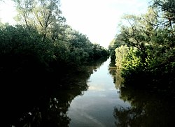
The Great Morava is the final section of the Morava, a major river system in Serbia.

The Yantra is a river in northern Bulgaria, a right tributary of the Danube. It is 285 km (177 mi) long, and has a watershed of 7,862 km2 (3,036 sq mi). Its average discharge at the mouth is 47 m3/s (1,700 cu ft/s).
The Tara is a river in Montenegro and Bosnia and Herzegovina. It emerges from the confluence of the Opasnica and Veruša rivers in the Komovi Mountains, part of the Dinaric Alps of Montenegro. The total length is 146 km, of which 141 km are in or on the border of Montenegro,; it also forms the border between the two countries in several places. The Tara flows from south to north - north-west and converges with the Piva at the Bosnia and Herzegovina and Montenegro border between the villages of Šćepan Polje (Montenegro) and Hum to form the Drina river.

The Iskar is a right tributary of the Danube. With a length of 368 km it is the longest river that runs entirely within Bulgaria. Originating as three forks in Balkan's highest mountain range Rila, it flows in northern direction until its confluence with the Danube River. As it flows northwards it fuels the largest artificial lake in the country, the Iskar Reservoir, forms the divide between the Vitosha and Plana Mountains in the west and the Sredna Gora mountain range in the east before entering the Sofia Valley, which contains the nation's capital Sofia. From there the Iskar runs through the Balkan Mountains forming the spectacular 84 km long Iskar Gorge and as it crosses the mountains its water course turns in north-eastern direction at Lakatnik. North of the Balkan Mountains the river crosses the Danubian Plain and finally flows into the Danube between the villages of Baykal and Gigen. Geologically, Iskar is the oldest river in the Balkan Peninsula.

Žagubica is a village and municipality located in the Braničevo District of the eastern Serbia. It is situated in the geographical region of Homolje. In 2011, the population of the village is 2,584, while population of the municipality is 12,737.

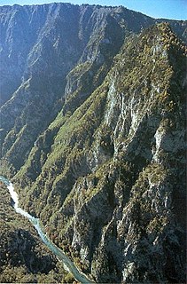
The South Morava is a river in eastern Kosovo and in southern Serbia, which represents the shorter headwater of Great Morava. Today, it is 295 km long, including its source river Binačka Morava. It flows generally in the south to north direction, from the Macedonian border to Kosovo and onwards to Central Serbia, where it meets West Morava at Stalać, to create Great Morava.
The Lim is a river that flows through Montenegro, Serbia and Bosnia and Herzegovina and is 219 km (136 mi) long. It is also the right and the longest tributary of the Drina.

The Pek is a river in eastern Serbia. It is a 129 km long right tributary of the Danube, flowing through the regions of Homolje, Zvižd and Braničevo.
The Resava is a river in central Serbia, a 65 km-long right tributary to the Velika Morava. It also gives the name to the surrounding Resava region, the Resava Monastery, the coal mines in its valley and a popular tourist destination of Resava Cave.
The Porečka River is a river in eastern Serbia, a 50 km-long right tributary to the Danube in the Đerdap gorge. It originates from two headstreams, the Šaška and the Crnajka rivers, which meet at the village of Miloševa Kula.

The Morava Valley, is a general term which in its widest sense marks valleys of any of three Morava rivers in Serbia: the West Morava, the South Morava and the Great Morava. In the narrow sense, the term is applied only to the Great Morava Valley. The Serbian term follows the general manner of coining river valley names in Serbian using the prefix po- and suffix -je, meaning literally "(land) along the Morava". Morava valley lies in the central Balkans, at the crossroads which lead eastwards, towards the Black sea and Asia Minor, and further south, down the Vardar river into the Aegean sea.

Homolje is a small geographical region in east Serbia south of the Danube river. It is centered on the town of Žagubica, with smaller parts belonging to municipalities of Kučevo, Majdanpek and Petrovac. In the narrow sense, the term "Homolje" is applied only to the Homolje valley around Mlava river, but it is usually applied to the low Homolje mountains (940 m) north of the valley and Beljanica and Crni Vrh mountains at the south. It is sparsely populated, and renowned for its unspoiled nature.

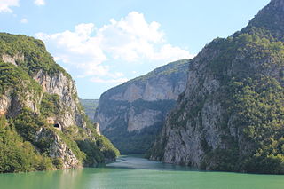
The Danube is a river that was once a long-standing frontier of the Roman Empire and today connects 10 European countries, running through their territories or being a border. Originating in Germany, the Danube flows southeast for 2,850 km (1,770 mi), passing through or bordering Austria, Slovakia, Hungary, Croatia, Serbia, Romania, Bulgaria, Moldova, and Ukraine before draining into the Black Sea. Its drainage basin extends into nine more countries. The largest cities on the river are Vienna, Budapest, Belgrade and Bratislava, all of which are the capitals of their respective countries. The Danube passes through four capital cities, more than any other river in the world. Five more capital cities lie in the Danube's basin: Bucharest, Sofia, Zagreb, Ljubljana and Sarajevo. The fourth-largest city in its basin is Munich, the capital of Bavaria, standing on the Isar River.
The Bunica is a short river in Bosnia and Herzegovina and a left bank tributary of the Buna. Its source, located in a place called Parila under sharp cliffs between the two villages of Hodbina and Malo Polje, is 14 km south from Mostar. It is a very deep and strong karstic spring and difficult to access. Together with the Buna river, it flows west for approximately 10 km and joins the Neretva river near Buna village. The Bunica is a main tributary of the Buna.

Kučaj is a mountain range in eastern Serbia. Its highest peak, Velika Tresta has an elevation of 1,284 meters above sea level. They belong to the Serbian extension of Carpathians, which separate the valleys of Great Morava and Timok.
Ježevac is a mountain in eastern Serbia, near the town of Petrovac na Mlavi. Its highest peak has an elevation of 675 meters above sea level. Ježevac sharply rises over the southern edge of Mlava river gorge, entering the Homolje region. On the mountain, there is Gornjak Monastery Monastery carved into limestone rocks.

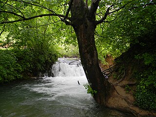
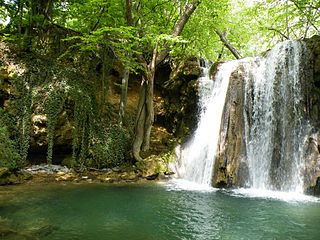
The Krupaj spring is a water spring in Eastern Serbia and Pomoravlje district below the western limestone massif of Beljanica, on the right side of the river Krupaj, at the altitude of 220 metres (720 ft). It is close to the village Milanovac, 35 kilometres (22 mi) from Žagubica.
The Blederija is a natural monument in eastern Serbia. It was placed under the state protection as the geological phenomenon and includes various geological formations in the watershed of the Blederija river, on the Miroč mountain.