Vranje is a city in Southern Serbia and the administrative center of the Pčinja District. The municipality of Vranje has a population of 74,381 and its urban area has 55,214 inhabitants.

The Mačva District is one of eight administrative districts of Šumadija and Western Serbia. It expands in the western parts of Serbia, in the geographical regions of Mačva, Podrinje, Posavina, and Pocerina. According to the 2011 census results, it has a population of 298,931 inhabitants. The administrative center of the Mačva district is the city of Šabac.
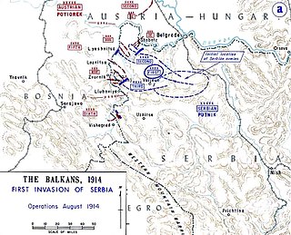
The Battle of Cer was a military campaign fought between Austria-Hungary and Serbia in August 1914, starting three weeks into the Serbian Campaign of 1914, the initial military action of the First World War. It took place around Cer Mountain and several surrounding villages, as well as the town of Šabac. The Battle of Cer is known as the first Allied victory over the Central Powers in the First World War.

Zvornik is a city in Republika Srpska, Bosnia and Herzegovina. In 2013, it had a population of 58,856 inhabitants.

Loznica is a city located in the Mačva District of western Serbia. It lies on the right bank of the Drina river. In 2022 the city had a total population of 19,515, while the administrative area had a population of 72,062.
The Jerez is a river in western Serbia, a 56 km-long right tributary to the Sava river.
Vrčin is a suburban settlement of Belgrade, Serbia. It is located in Belgrade's municipality of Grocka.
The Jadar region begins roughly at the Osečina and it is divided in two sub-regions: Upper Jadar, which is part of much larger region of Rađevina, and Lower Jadar, which is also part of another, larger region of Podrinje. Center of the Lower Jadar is the town of Loznica, which is not on the Jadar river, but some 10 km to the southwest.

Zasavica II, also known as Donja Zasavica, is a village in the Sremska Mitrovica municipality, in the Vojvodina province of Serbia. The village has a Serb ethnic majority and its population numbering 608 people. Although part of the Srem District, Zasavica II is situated in the region of Mačva south of the Sava river. With the adjacent village of Zasavica I, it still forms a single cadastral unit, although they are treated as separate villages for census purposes.

Tekeriš is a village in Serbia. It is situated in the Loznica municipality, in the Mačva District. This village has a Serbian ethnic majority and its population numbers 370 people, according to the 2002 census.
Lipolist is a village in Serbia. It is situated in the Šabac municipality, in the Mačva District. The village has a Serb ethnic majority and its population numbering 2,582 people.
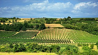
There are nearly 70,000 hectares of vineyards in Serbia, producing about 425,000 tons of grapes annually. The majority of Serbian wines are produced in local wineries.

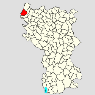
Gornja Orovica is a village in Serbia. It is situated in the Ljubovija municipality, in the Mačva District of Central Serbia. The village had a Serb ethnic majority and a population of 415 in 2002.
Gornja Ljuboviđa is a village in Serbia. It is situated in the Ljubovija municipality, in the Mačva District of Central Serbia. The village had a Serb ethnic majority and a population of 443 in 2002.

Gredetin is a village in the municipality of Aleksinac, Serbia. The Gredetin settlement is located on the 15 kilometers from the town of Aleksinac.

Gornja Vranjska is a town in the municipality of Šabac, Serbia. According to the 2002 census, the town has a population of 1582 people.

Mala Vranjska is a village in the municipality of Šabac, Serbia. According to the 2002 census, the village has a population of 801 people.

Gornja Grabovica is a village in the municipality of Valjevo, Serbia. According to the 2002 census, the village has a population of 1366 people.

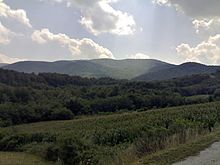
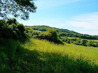
Rađevina is an area in northwestern Serbia between mountains Vlašić, Cer, Jagodnja and Sokolska planina. Along with the Azbukovica they form the Upper Drina region. Rađevina is predominantly hilly and mountainous region full of forests and pastures with clear and rapid streams. The highest peak is Košutnja stopa on the mountain Jagodnja.

The Cer Memorial is a war memorial commemorate the Battle of Cer, fought in 1914 as part of the First World War. It is situated on the battlefield, in the village of Tekeriš on the mountain Cer, near Loznica, Serbia. Memorial ossuary Cer is on the list of Immovable Cultural Heritage of Exceptional Importance.