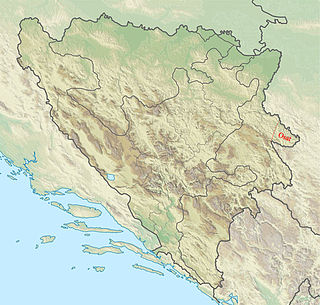
Zvornik is a city in Republika Srpska, Bosnia and Herzegovina. In 2013, it had a population of 58,856 inhabitants.

Semberija is a geographical region in north-eastern Bosnia and Herzegovina. The main city in the region is Bijeljina. Semberija is located between the Drina and Sava rivers and Majevica mountain. Most of the region is administratively situated in the entity of Republika Srpska, and the smaller part in the entity of Federation of Bosnia and Herzegovina. Semberija has a very rich history. It was first mentioned in 1533 during the Ottoman rule. The name Semberija is of Hungarian origin and probably related to the time of the 12th-16th centuries when this area was occasionally held by the Hungarian Kingdom. Today about 200,000 people live in the area of Semberija, most in the municipality of Bijeljina.
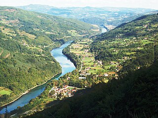
Perućac is a village in western Serbia, in the municipality of Bajina Bašta. It is situated at the right bank of the 346 km-long Drina River, which constitutes the natural border between Serbia and Bosnia and Herzegovina. According to the 2011 Census, the village has 530 residents.

Podrinje is the Slavic name of the Drina river basin, known in English as the Drina Valley. The Drina basin is shared between Bosnia and Herzegovina and Serbia, with majority of its territory being located in Eastern Bosnia, entire Upper Drina course and majority of the Middle course, while the Lower Drina course is shared between two countries,with the river representing border. The part of the Drina basin located in Bosnia and Herzegovina is also called Eastern Bosnia.

Lešnica is a village in western Serbia. It is located in the municipality of Loznica, in the Mačva District. Lešnica's current population is 4,731.
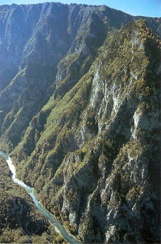
The Tara River Canyon, also known as the Tara River Gorge, is the river canyon of the Tara river. It is for the most part located in Montenegro, and to a smaller extent in Bosnia and Herzegovina. The most attractive part of the canyon are the high rocks of the mountain range of Ljubišnja, which are located in the UNESCO World Heritage Site of Durmitor National Park. Known as "The Tear of Europe," the Tara River Gorge stands as the second deepest canyon in Europe behind the Sulak Canyon, and also behind the Grand Canyon for third deepest globally.

Janja is a town in Bijeljina, Bosnia and Herzegovina. It is known as a place where the confluence of the rivers Janja and Drina is situated. It is the only Bosniak community in the municipality and consists of many displaced persons from other parts of Bosnia and Herzegovina.

Crna Bara is a village in Serbia, in the Mačva region. Administratively it belongs to the municipality of Bogatić. According to the 2002 census, the village had 2,270 residents. It lies near the confluence of Drina river into Sava.
Karakaj is a town located 2 km (1.2 mi) north of the city Zvornik in Bosnia and Herzegovina on the Drina River. It also has a border checkpoint with Serbia.

Štitar is a village in Serbia, located around 9 km west from the town of Šabac, in Mačva District.

The Drina is a 346 km (215 mi) long river in the Balkans, which forms a large portion of the border between Bosnia and Herzegovina and Serbia. It is the longest tributary of the Sava River and the longest karst river in the Dinaric Alps which belongs to the Danube River drainage basin. Its name is derived from the Roman name of the river which in turn is derived from Greek.
Amajić is a village in west-central Serbia. It is situated in the municipality of Mali Zvornik in the Mačva District of Central Serbia. The village is located on the banks of Zvornik Lake, a reservoir of the Drina River, on the international border between Serbia and Bosnia and Herzegovina. The population was 156 at the 2011 census.
Donja Borina is a village in Serbia. It is situated in the Mali Zvornik municipality, in the Mačva District of Central Serbia. The village has a Serb ethnic majority and its population was 1,731 in 2002.

Vrhpolje (Врхпоље) is a village in Serbia. It is in the Municipality of Ljubovija, in the Mačva District of Central Serbia.
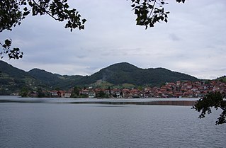
Divič is a village by the city of Zvornik, Bosnia and Herzegovina. It is located on the Drina River, by an artificial lake created to form a reservoir for the HPP Zvornik hydro-electric power plant. The Drina River and the lake are a natural and administrative border between Bosnia and Herzegovina and Serbia and during the international armed conflict of 1992–95 the village was "ethnically cleansed" of its Bosniak inhabitants by Serb forces.
Jelav is a village in the municipality of Loznica, Serbia. According to the 2011 census, the village has a population of 854.

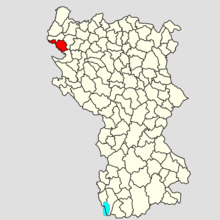
Rađevina is an area in northwestern Serbia between mountains Vlašić, Cer, Jagodnja and Sokolska planina. Along with the Azbukovica they form the Upper Drina region. Rađevina is predominantly hilly and mountainous region full of forests and pastures with clear and rapid streams. The highest peak is Košutnja stopa on the mountain Jagodnja.
Osat is a region in central Podrinje, in Bosnia and Herzegovina. It is situated between the towns of Višegrad and Srebrenica, and includes parts of the municipalities of Bratunac and Srebrenica. It is part of the wider Birač region.
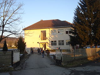
Svilile is a village in the municipality of Bratunac, Bosnia and Herzegovina. It is approximately 1.2 km northeast of Nova Kasaba.

Jovan Simić Bobovac was a Serbian politician, who began his career as knez during the Ottoman period, participated in the Serbian Revolution (1804–17), and served as the President of the Serbian Supreme Court. He was one of the closest collaborators of Prince Miloš Obrenović.