a Kordun is not designated as an official region, it is a geographic region only.
Region of Croatia
The Kordun (Croatian pronunciation:[kǒrduːn]) region is a part of central Croatia from the bottom of the Petrova Gora (Peter's mountain) mountain range, which extends along the rivers Korana and Slunjčica, and forms part of the border region to Bosnia and Herzegovina. Within Croatia, Kordun is bordered by the Lika region to the south and by Banovina or Banija to the east.
The area has rich wood resources. Today, the economic situation is slowly improving, but there is still a large tendency of emigration from the region to larger cities. A typical phenomenon of this region is the porous composition of the karst soil (consisting of limestone), which creates numerous crater-like dolines (sinkholes, Croatian dolina).[citation needed]
Name
The name Kordun was created during the period of the Military Frontier and is closely related to the strategic significance of the region. It comes from the French word "cordon militaire" which translates into military belt. In this case, it refers to a series of former linked guardhouses and forts with the aim of repelling armies coming from the formerly Turkish controlled territory of western Bosnia.
Operation Storm was the last major battle of the Croatian War of Independence and a major factor in the outcome of the Bosnian War. It was a decisive victory for the Croatian Army (HV), which attacked across a 630-kilometre (390 mi) front against the self-declared proto-state Republic of Serbian Krajina (RSK), and a strategic victory for the Army of the Republic of Bosnia and Herzegovina (ARBiH). The HV was supported by the Croatian special police advancing from the Velebit Mountain, and the ARBiH located in the Bihać pocket, in the Army of the Republic of Serbian Krajina's (ARSK) rear. The battle, launched to restore Croatian control of 10,400 square kilometres of territory, representing 18.4% of the territory it claimed, and Bosniak control of Western Bosnia, was the largest European land battle since World War II. Operation Storm commenced at dawn on 4 August 1995 and was declared complete on the evening of 7 August, despite significant mopping-up operations against pockets of resistance lasting until 14 August.
Plitvice Lakes National Park is one of the oldest and largest national parks in Croatia. In 1979, Plitvice Lakes National Park was inscribed on the UNESCO World Heritage list, for its outstanding and picturesque series of tufa lakes, caves, and connected waterfalls.
Lika is a traditional region of Croatia proper, roughly bound by the Velebit mountain from the southwest and the Plješevica mountain from the northeast. On the north-west end Lika is bounded by Ogulin-Plaški basin, and on the south-east by the Malovan pass. Today most of the territory of Lika is part of Lika-Senj County. Josipdol, Plaški and Saborsko are part of Karlovac County and Gračac is part of Zadar County, and it takes up about 12% of Croatia's land area.
Karlovac County is a county in central Croatia, with the administrative center in Karlovac. It borders Bosnia and Herzegovina and Slovenia.
The Military Frontier was a borderland of the Habsburg monarchy and later the Austrian and Austro-Hungarian Empire. It acted as the cordon sanitaire against incursions from the Ottoman Empire.
The Croatian Military Frontier was a district of the Military Frontier, a territory in the Habsburg monarchy, first during the period of the Austrian Empire and then during Austria-Hungary.
The Modruš-Rijeka County was a historic administrative subdivision of the Kingdom of Croatia-Slavonia. Croatia-Slavonia was an autonomous kingdom within the Lands of the Crown of Saint Stephen (Transleithania), the Hungarian part of the dual Austro-Hungarian Empire. Its territory is now in western Croatia. Modruš is a small town near Ogulin; Rijeka is a large city on the Adriatic coast. However, Rijeka was not part of the Modruš-Rijeka County, but under the direct administration of Hungary. The capital of the county was Ogulin.
Cetingrad is a municipality in Karlovac County, Croatia near Croatia's border with Bosnia. The population of the village itself is 319, while the total municipality population is 2,027 (2011). The municipality is part of Kordun. Cetingrad is underdeveloped municipality which is statistically classified as the First Category Area of Special State Concern by the Government of Croatia.
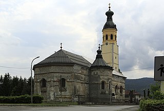
Slunj is a town in the mountainous part of Central Croatia, located along the important North-South route to the Adriatic Sea between Karlovac and Plitvice Lakes National Park, on the meeting of the rivers Korana and Slunjčica. Slunj has a population of 1,674, with a total of 5,076 people in the municipality (2011) and is the cultural and social center of the region of Kordun in the vicinity to Bosnia and Herzegovina. Administratively, the town is part of Karlovac County. Slunj is an underdeveloped municipality which is statistically classified as part of the First Category Area of Special State Concern by the Government of Croatia.
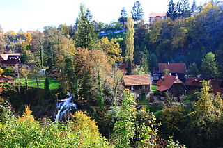
Rastoke is a village, located in the Town of Slunj, known for the Slunjčica River, which flows into the Korana River at Rastoke.
Banovina or Banija is a geographical region in central Croatia, between the Sava, Una, Kupa and Glina rivers. The main towns in the region include Petrinja, Glina, Kostajnica, and Dvor. There is no clear geographical border of the region towards the west and the neighboring region of Kordun. The area of Banovina is today administratively almost entirely located within the Sisak-Moslavina County.
In contemporary geography, the terms Central Croatia and Mountainous Croatia are used to describe most of the area sometimes historically known as Croatia or Croatia proper, one of the four historical regions of the Republic of Croatia, together with Dalmatia, Istria, and Slavonia. It is located between Slavonia in the east, the Adriatic Sea in the west, and Dalmatia to the south. The region is not officially defined, and its borders and extent are described differently by various sources. The term Central Croatia refers to the northeastern part, and the term Mountainous Croatia refers to the southwestern part of the territory; the far western part is known as the Croatian Littoral; likewise the terms 'Zagreb macroregion' and 'Rijeka macroregion' can be used instead. Central Croatia is the most significant economic area of the country, contributing well over 50% of Croatia's gross domestic product. The capital of the Republic of Croatia, Zagreb, is the largest city and most important economic centre in Central Croatia.
Petrova Gora is a mountain in the Kordun region of central Croatia. It is administratively part of the Karlovac County and the Sisak-Moslavina County. It extends northeast-southwest, some 25 kilometers along the border with Bosnia and Herzegovina.
Srijemske Laze is a village in Stari Jankovci municipality of Vukovar-Syrmia County in eastern Croatia. The village is physically connected with the village of Slakovci. According to 2011 census there is 566 residents in the village. The largest ethnic group in the village are Serbs of Croatia. The village is connected with the rest of the country by the D46 state road connecting it with the town of Vinkovci and continuing into Serbia as the State Road 120 to the nearest town of Šid. Surrounding landscape of the village is marked by the Pannonian Basin plains and agricultural fields of wheat, maize, common sunflower and sugar beet.
Slabinja is a village in the Sisak-Moslavina County in the central part of Croatia. It is in the Una Valley near the border with Bosnia and Herzegovina, 12.6 kilometres (7.8 mi) southeast of the town of Hrvatska Kostajnica, 9.7 kilometres (6 mi) northwest of the village of Hrvatska Dubica, and 106 kilometres (66 mi) southeast of Croatian capital Zagreb, at the south fringe of the Banovina region. Slabinja is a dormitory village with a resident population of just over 250 people.
Glina is a river in central Croatia and Bosnia and Herzegovina, a right tributary of Kupa. It is 112 kilometres (70 mi) long and its basin covers an area of 1,427 square kilometres (551 sq mi).
Posavina is a geographical region that stretches along the Sava river, encompassing only the inner areas of the Sava river basin, that are adjacent or near to the Sava river itself, namely catch region spanning from the Julian Alps in the northwest to the confluence with the Danube in the southeast. It passes through several countries of former Yugoslavia, namely Slovenia, Croatia, Bosnia and Herzegovina and Serbia. In Slovene, the term Posavina is not used to describe the parts of Slovenia that lie by the Sava river. Instead, the terms Posavje, Zasavje and Zgornjesavska dolina are used.
Trepča is a village in central Croatia, in the municipality of Gvozd, Sisak-Moslavina County. It is connected by the D6 highway.
Strmen is a village in central Croatia, in the municipality of Sunja, Sisak-Moslavina County. It is located in the Banija region.
The siege of Slunj was an armed conflict in the territory of the municipality of Slunj in 1991 during the Croatian War of Independence. It was fought between the Croatian Army (HV) on one side, and the Yugoslav People's Army (JNA) on the other. It was the largest Croatian enclave that was separated from the rest of Croatia during the conflict. After the JNA took over Slunj, over 16,000 Croats were expelled from the enclave and hundreds were murdered in war crimes during the occupation until the end of the war.
This page is based on this Wikipedia article Text is available under the CC BY-SA 4.0 license; additional terms may apply. Images, videos and audio are available under their respective licenses.