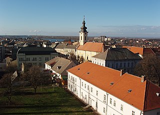
Sremska Mitrovica is a city and the administrative center of the Srem District in the autonomous province of Vojvodina, Serbia. It is situated on the left bank of the Sava river. As of 2022, the city has a total population of 40,144 inhabitants, while its administrative area has a population of 72,580 inhabitants.

Vukovar-Srijem County, Vukovar-Sirmium County or Vukovar-Syrmia County, named after the eponymous town of Vukovar and the region of Syrmia, is the easternmost Croatian county. It includes the eastern parts of the region of Slavonia and the western parts of the region of Syrmia, as well as the lower Sava river basin, Posavina and Danube river basin Podunavlje. Due to the overlapping definitions of geographic regions, division on Slavonia and Syrmia approximately divides the county vertically into north-west and south-east half, while division on Posavina and Podunavlje divides it horizontally on north-east and south-west half.

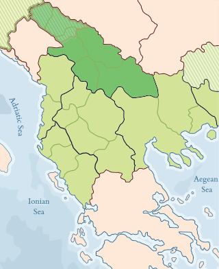
Syrmia is a region of the southern Pannonian Plain, which lies between the Danube and Sava rivers. It is divided between Serbia and Croatia. Most of the region is flat, with the exception of the low Fruška gora mountain stretching along the Danube in its northern part.
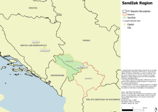
Sandžak is a historical geo-political region located in the southwestern part of Serbia and the eastern part of Montenegro. The name Sandžak derives from the Sanjak of Novi Pazar, a former Ottoman administrative district founded in 1865.
The Srem District is one of seven administrative districts of the autonomous province of Vojvodina, Serbia. It lies in the geographical regions of Syrmia and Mačva. According to the 2022 census results, it has a population of 282,547 inhabitants. The administrative center is the city of Sremska Mitrovica.

Syrmia County was a historic administrative subdivision (županija) of the Kingdom of Croatia-Slavonia. Croatia-Slavonia was an autonomous kingdom within the Lands of the Crown of Saint Stephen (Transleithania), the Hungarian part of Austria-Hungary. The region of Syrmia is today split between Croatia and Serbia. The capital of the county was Vukovar.
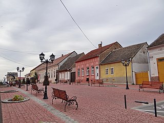
Irig is a town and municipality located in the Srem District of the autonomous province of Vojvodina, Serbia. The town has a population of 4,415, while Irig municipality has 10,866 inhabitants.
Podunavlje is the name of the Danube river basin parts located in Croatia and Serbia. Podunavlje is located on the southern edge of Pannonian Basin. In its wider meaning, the Croatian term refers to the area around the entire flow of the river Danube.
Vojvodina is an autonomous province located in northern Serbia. It consists of the Pannonian Plain in the south, and the Danube and Sava rivers in the north.
The Vilayet of Kosovo was a first-level administrative division (vilayet) of the Ottoman Empire in the Balkan Peninsula which included the modern-day territory of Kosovo and the north-western part of the Republic of North Macedonia. The areas today comprising Sandžak (Raška) region of Serbia and Montenegro, although de jure under Ottoman control, were de facto under Austro-Hungarian occupation from 1878 until 1909, as provided under Article 25 of the Treaty of Berlin. Üsküb (Skopje) functioned as the capital of the province and the midway point between Istanbul and its European provinces. Üsküb's population of 32,000 made it the largest city in the province, followed by Prizren, also numbering at 30,000.
Ilok is the easternmost town in Croatia forming a geographic salient surrounded by Vojvodina. Located in the Syrmia region, it lies on the Fruška Gora hill overlooking the Danube river, which forms the border with the Bačka region of Serbia. The town is home to a Franciscan monastery and Ilok Castle, which is a popular day trip for domestic and cross-border tourists.

The Sanjak of Smederevo, also known in historiography as the Pashalik of Belgrade, was an Ottoman administrative unit (sanjak), that existed between the 15th and the outset of the 19th centuries. It was located in the territory of present-day Central Serbia, Serbia.
The Sanjak of Novi Pazar was an Ottoman sanjak that was created in 1865. It was reorganized in 1880 and 1902. The Ottoman rule in the region lasted until the First Balkan War (1912). The Sanjak of Novi Pazar included territories of present-day northeastern Montenegro and southwestern Serbia, also including some northern parts of Kosovo. In modern day terms the region is known as Sandžak.

The Ottoman Empire era of rule in Bosnia and Herzegovina and Herzegovina lasted from 1463/1482 to 1878 de facto, and until 1908 de jure.
The Sanjak of Üsküp was one of the sanjaks in the Ottoman Empire, with Üsküb as its administrative centre.

Muftiship of Novi Sad is one of the four muftiships of the Islamic Community in Serbia. Muftiship is including territory of the Autonomous Province of Vojvodina and its seat is in Novi Sad. Administrator of the muftiship is mufti Fadil Murati.
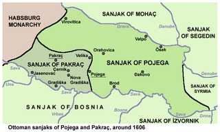
The Sanjak of Pojega was an administrative territorial entity of the Ottoman Empire formed around 1538. It existed until the Treaty of Karlowitz (1699), when the region was transferred to the Habsburg monarchy. It was located in present-day eastern Croatia, in the Slavonia region. The capital of the sanjak was Pojega.

Syrmia Oblast was one of the oblasts of the Kingdom of Serbs, Croats and Slovenes from 1922 to 1929. Its administrative center was Vukovar.
The Sanjak of Pakrac or Sanjak of Čazma or Sanjak of Cernica was one of the sanjaks of the Ottoman Empire whose capital was first Zaçasna and then Pakrac and Cernik in Ottoman Slavonia. It was established after the Ottomans captured Slavonia in the mid 16th century.

The remaining Ottoman Empire era monuments of Ilok, town in eastern Croatia, include the hammam and the türbe which makes the town the location with the largest number of preserved Ottoman buildings in Slavonia. The hammam in Ilok is the only preserved Ottoman era hammam in Croatia. Evliya Çelebi, Ottoman explorer who travelled through the Empire, described the hammam of Ilok in his recollections from the town.


