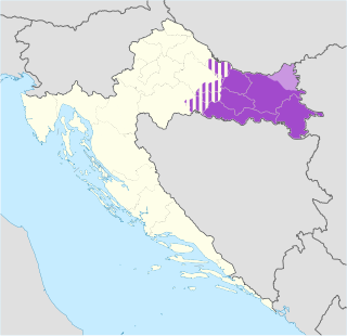
Slavonia is, with Dalmatia, Croatia proper and Istria, one of the four historical regions of Croatia. Taking up the east of the country, it roughly corresponds with five Croatian counties: Brod-Posavina, Osijek-Baranja, Požega-Slavonia, Virovitica-Podravina and Vukovar-Syrmia, although the territory of the counties includes Baranya, and the definition of the western extent of Slavonia as a region varies. The counties cover 12,556 square kilometres or 22.2% of Croatia, inhabited by 806,192—18.8% of Croatia's population. The largest city in the region is Osijek, followed by Slavonski Brod and Vinkovci.

Georg Friedrich Creuzer was a German philologist and archaeologist.

Syrmia is a region of the southern Pannonian Plain, which lies between the Danube and Sava rivers. It is divided between Serbia and Croatia. Most of the region is flat, with the exception of the low Fruška gora mountain stretching along the Danube in its northern part.

Daruvar is a spa town and municipality in Slavonia, northeastern Croatia, with a population of 8,567, as of 2011. It is located on the foothills of Papuk mountain and along the Toplica river. The main political and cultural centre of the Czech national minority in Croatia, it has a winemaking tradition reportedly dating back more than 2000 years.
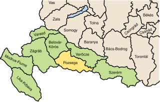
Požega County was a historic administrative subdivision (županija) of the Kingdom of Croatia-Slavonia. Croatia-Slavonia was an autonomous kingdom within the Lands of the Crown of Saint Stephen (Transleithania), the Hungarian part of the dual Austro-Hungarian Empire. Its territory is now in eastern Croatia. The capital of the county was Požega.

Syrmia County was a historic administrative subdivision (županija) of the Kingdom of Croatia-Slavonia. Croatia-Slavonia was an autonomous kingdom within the Lands of the Crown of Saint Stephen (Transleithania), the Hungarian part of Austria-Hungary. The region of Syrmia is today split between Croatia and Serbia. The capital of the county was Vukovar.

Virovitica County was a historic administrative subdivision (županija) of the Kingdom of Croatia-Slavonia. Croatia-Slavonia was an autonomous kingdom within the Lands of the Crown of Saint Stephen (Transleithania), the Hungarian part of the dual Austro-Hungarian Empire. Its territory is now in eastern Croatia. The name of the county comes from the town of Virovitica. The capital of the county moved from Virovitica to Osijek in the late 18th century.

Heinrich Karl Wilhelm Berghaus was a German geographer and cartographer who conducted trigonometric surveys in Prussia and taught geodesy at the Bauakademie in Berlin. He taught cartography and produced a pioneering and influential thematic atlas which provided maps of flora, fauna, climate, geology, diseases and a range of other information. He was a friend of Alexander von Humboldt and produced some of the maps used in his publications. A nephew Hermann Berghaus also worked in cartography.

The Kingdom of Slavonia was a province of the Habsburg Monarchy and the Austrian Empire that existed from 1699 to 1868. The province included northern parts of present-day regions of Slavonia and Syrmia. The southern parts of these regions were part of the Slavonian Military Frontier, which was a section of the Military Frontier.

The Slavonian Military Frontier was a district of the Military Frontier, a territory in the Habsburg Monarchy, first during the period of the Austrian Empire and then during the Austro-Hungarian Monarchy. It was formed out of territories the Habsburgs conquered from the Ottoman Empire and included southern parts of Slavonia and Syrmia; today the area it covered is mostly in eastern Croatia, with its easternmost parts in northern Serbia.

Johannes Dümichen was a German Egyptologist.

Heinrich Brunn was a German archaeologist. He was known for taking a scientific approach in his investigations of classical Greek and Roman art, being credited with introducing the method of determining the date and source of sculptural fragments by way of thorough analysis of the account of anatomic detail.

Frederick Michael, Count Palatine of Zweibrücken-Birkenfeld was a member of the Wittelsbach dynasty. He was the son of Christian III of Palatinate-Zweibrücken and Caroline of Nassau-Saarbrücken and a member of the House of Palatinate-Zweibrücken-Birkenfeld, a branch of the House of Wittelsbach. He was the father of the Bavarian King Maximilian I Joseph.

Andautonia was a Roman settlement located on the southern bank of the river Sava, located in the modern-day village of Šćitarjevo, southeast of the city of Zagreb, Croatia.

Aquae Iasae was the Roman settlement and Roman bath in the area of present city Varaždinske Toplice, Croatia. Today it is the name of the archaeological site.
Iași is a city in Moldavia, northeastern Romania.

Marie Hedwig of Hesse-Darmstadt was a landgravine of Hesse-Darmstadt by birth and by marriage Duchess of Saxe-Meiningen.
Bubon or Boubon was a city of ancient Lycia noted by Stephanus of Byzantium; the ethnic name, he adds, ought to be Βουβώνιος, but it is Βουβωνεύς, for the Lycians rejoice in this form. The truth of this observation of Stephanus is proved by the inscription found on the spot: Βουβωνέων ἡ Βουλὴ καὶ ὁ Δῆμος. Bubon is placed in the map in Spratt's Lycia, near 37° N. lat. west of Balbura, near a place named Ibecik, which location is confirmed by modern scholars. Bubon is mentioned by Pliny, Ptolemy, and Hierocles. Pliny mentions a kind of chalk (creta) that was found about Bubon. The city stood on a hill side. The ruins are not striking. There is a small theatre built of sandstone, and on the summit of the hill was the acropolis. Bubon is in a mountainous tract and it commands the entrance to the pass over the mountains. Bubon, along with Balbura and Oenoanda formed the district Cabalia.
The Brabant Road, Cologne to Leipzig Road or Liege Road is an ancient road which, during the Middle Ages and Early Modern Period, was one of the most important continental east-west oriented military and trade routes. It ran from the eponymous Duchy of Brabant to Leipzig.
