The administrative divisions of the Ottoman Empire were administrative divisions of the state organisation of the Ottoman Empire. Outside this system were various types of vassal and tributary states.

The North Bačka District is one of seven administrative districts of the autonomous province of Vojvodina, Serbia. It lies in the Bačka geographical region. According to the 2011 census results, it has a population of 186,906 inhabitants. The administrative center of the district is the city of Subotica.

The West Bačka District is one of seven administrative districts of the autonomous province of Vojvodina, Serbia. It lies in the geographical region of Bačka. It has a population of 188,087 inhabitants. The administrative seat of the district is the city of Sombor.

The South Bačka District is one of seven administrative districts of the autonomous province of Vojvodina, Serbia. Geographically it lies in the southern part of Bačka and northern part of Syrmia. According to the 2011 census results, it has a population of 615,371 inhabitants. The administrative center of the district is the city of Novi Sad, which is also the capital and the largest city of the Autonomous Province of Vojvodina.

The Bosnia Vilayet was a first-level administrative division (vilayet) of the Ottoman Empire, mostly comprising the territory of the present-day state of Bosnia and Herzegovina. It bordered Kosovo Vilayet to the south. Before the administrative reform in 1867, it was called the Bosnia Eyalet. In the late 19th century it reportedly had an area of 17,900 square miles (46,000 km2).

Bács-Bodrog County was the administrative county (comitatus) of the Kingdom of Hungary from the 18th century to 1920. Its territory is currently in northern Serbia and southern Hungary. The capital of the county was Zombor.

Torontál was an administrative county (comitatus) of the Kingdom of Hungary. Its territory is now in northern Serbia, western Romania and southern Hungary. The capital of the county was Nagybecskerek, the current Zrenjanin.
Segedin or Šegedin may refer to:

Bač is a town and municipality located in the South Bačka District of the autonomous province of Vojvodina, Serbia. The town has a population of 5,399, while Bač municipality has 14,405 inhabitants. The entire geographical region between the rivers Danube and Tisza, today divided between Serbia and Hungary, was named Bačka after the town.

Vojvodina is the Serbian name for the territory in Northern Serbia, consisting of the southern part of the Pannonian Plain, mostly located north from the Danube and Sava rivers.

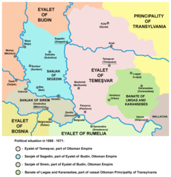
Varat Eyalet was an administrative territorial entity of the Ottoman Empire formed in 1660. Varat Eyalet bordered Ottoman Budin Eyalet in the west, Temeşvar Eyalet in the southwest, Egir Eyalet in the northwest, vassal Ottoman Principality of Transylvania in the southeast, and Habsburg Royal Hungary in the north.

The Eparchy of Bačka is an ecclesiastical territory or eparchy of the Serbian Orthodox Church in the Bačka region, Serbia. It is situated in the autonomous province of Vojvodina and seat of the eparchy is in Novi Sad.

The Eyalet of Vidin was an administrative territorial entity of the Ottoman Empire located in the territory of present-day north-western Bulgaria. It was formed in 1846 and its administrative centre was Vidin. It was incorporated into Danube Province in 1864 and its sanjaks were reduced to townships except Vidin.

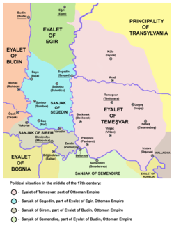
Budin Eyalet was an administrative territorial entity of the Ottoman Empire in Central Europe and the Balkans. It was formed on the territories that Ottoman Empire conquered from the medieval Kingdom of Hungary and Serbian Despotate. The capital of the Budin Province was Budin.

Eğri Eyalet or Pashaluk of Eğri was an administrative territorial entity of the Ottoman Empire formed in 1596 with its capital at Eğri. It included parts of present-day Hungary, Slovakia and Serbia.

Sanjak of Syrmia was an administrative territorial entity of the Ottoman Empire formed in 1541. It was located in the Syrmia region and was part of the Budin Province. Administrative center of the Sanjak of Syrmia was from 1542 Uyluk and in the second half of the 17th century it was Dimitrofça. Most of the sanjak was ceded to Austria according to Treaty of Karlovitz in 1699. Remainder of the territory of sanjak was transferred to Sanjak of Semendire and was later also ceded to Austria according to Treaty of Passarowitz in 1718.

Uyvar Eyalet was an eyalet of the Ottoman Empire.
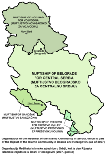
Muftiship of Novi Sad is one of the four muftiships of the Islamic Community in Serbia. Muftiship is including territory of the Autonomous Province of Vojvodina and its seat is in Novi Sad. Administrator of the muftiship is mufti Fadil Murati.


