
Mecklenburg is a historical region in northern Germany comprising the western and larger part of the federal-state Mecklenburg-Western Pomerania. The largest cities of the region are Rostock, Schwerin, Neubrandenburg, Wismar and Güstrow.
The Müritz National Park is a national park situated roughly in the middle between Berlin and Rostock, in the south of the German state of Mecklenburg-Vorpommern. It extends over large portions of the Müritz lakeland in the district of Mecklenburgische Seenplatte. Müritz National Park was founded in 1990. The total area is 318 km2. Near the city of Waren visitors can get information on the national park at the Müritzeum. The beech forests within the national park were inscribed on the UNESCO World Heritage List in 2011 as an extension of the Primeval Beech Forests of Europe site because of their unspoilt nature and testimony to the ecological history of Europe since the Last Glacial Period.

Mecklenburg-Strelitz was a Kreis (district) in the southern part of Mecklenburg-Western Pomerania, Germany. Neighboring districts were Demmin, Ostvorpommern Uecker-Randow, the districts Uckermark, Oberhavel and Ostprignitz-Ruppin in Brandenburg, and the district Müritz. The district-free city Neubrandenburg was nearly surrounded by the district.

Neustrelitz is a town in the Mecklenburgische Seenplatte district in the state of Mecklenburg-Vorpommern, Germany. It is situated on the shore of the Zierker See in the Mecklenburg Lake District. From 1738 until 1918 it was the capital of the Duchy of Mecklenburg-Strelitz. From 1994 until 2011 it was the capital of the district of Mecklenburg-Strelitz.

Mirow is a town in the district of Mecklenburgische Seenplatte in southern Mecklenburg-Vorpommern, Germany.

The Kellerwald is a low mountain range reaching heights of up to 675 m in the western part of northern Hesse, Germany. Its assets include Germany's largest contiguous beech woodland and it contains Hesse's only national park, the Kellerwald-Edersee National Park. It is a UNESCO World Heritage Site.

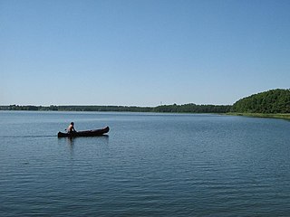
The Mecklenburg Lake Plateau or Mecklenburg Lakeland is the largest coherent lake and canal region in Germany and is sometimes called "the land of a thousand lakes". There are several nature parks and well-known lakes with unique flora and fauna in the region, such as the Müritz, the biggest German lake lying entirely within Germany, the Plauer See, the Fleesensee, the Tollensesee, the Schmaler Luzin and the Kölpinsee.
The Feldberg Lake District Nature Park lies in the southeast of the German state of Mecklenburg-Vorpommern in the district of Mecklenburgische Seenplatte. A large part of the nature park lies within the municipality of the same name, the Feldberger Seenlandschaft. In addition the municipalities of Wokuhl-Dabelow, Grünow, Carpin, Godendorf and parts of the towns of Woldegk and Neustrelitz fall within the nature park. The western end of the park is also a part of Müritz National Park.

The Prince-Bishopric of Ratzeburg was an ecclesiastical principality of the Holy Roman Empire that was located in what is today the states of Schleswig-Holstein and Mecklenburg-Vorpommern in Germany. It was established in 1236 and disestablished following the Peace of Westphalia in 1648. The state capital was the city of Ratzeburg. The Diocese of Ratzeburg had originally been established as a diocese of the Catholic Church in the 11th century but had fallen into abeyance; as a result of the Wendish Crusade, the diocese was re-created in the middle of the 12th century. The territory of the prince-bishopric was managed by secular lords on behalf of the Bishop of Ratzeburg. As a Prince-Bishopric of the Empire, the territory of the state was not identical with that of the bishopric, but was located within its boundaries and made up about a quarter of the diocesan area. When the Prince-Bishopric was disestablished, a new entity was established — the Principality of Ratzeburg. The principality became an exclave of the Duchy of Mecklenburg-Strelitz.

Keutschacher See is a lake of Carinthia, Austria. It is sixth-largest in Carinthia, with an area of 1.32 km2 (0.51 sq mi). It has a Neolithic stilt settlement, discovered by Ferdinand von Hochstetter in 1864.

The Rehburg Hills are a hill range, up to 161.4 m above sea level (NN), in the districts of Nienburg and Schaumburg in Lower Saxony, Germany.
Mecklenburgische Seenplatte is a district in the southeast of Mecklenburg-Vorpommern, Germany. It is bounded by the districts Ludwigslust-Parchim, Rostock (district), Vorpommern-Rügen, Vorpommern-Greifswald, and the state Brandenburg to the south. The district covers the largest area of all German districts and more than doubles the area of the state Saarland. The district seat is the town Neubrandenburg.
The Ruhn Hills are a terminal moraine ridge up to 176.8 m above sea level (NHN), which lies on either side of the border between the German states of Brandenburg and Mecklenburg-Vorpommern near Parchim. After the Helpt Hills they are the second highest points in the latter federal state.
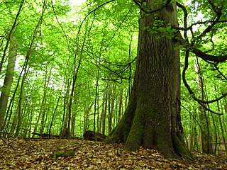
The Heilige Hallen are one of the oldest beech woods in Germany and are found in the district of Mecklenburgische Seenplatte in Mecklenburg, 3.5 kilometres west of Feldberg. In the mid 19th century, Grand Duke George of Strelitz, impressed by the giant, columnar trees, ordered that this woodland should be protected and looked after for all time. The 25 hectare core area of the forest has been a nature reserve since the 24 February 1938. Because several of the already 350-year-old, up-to-53-metre-high trees have exceeded their natural life span, the wood today has a large amount of dead wood. In 1993 the area of the reserve was increased from 25 to 65.5 hectares.

The Neustrelitz Little Lakes Region is a landscape in the south of the German state of Mecklenburg-Vorpommern, in the region around the town of Neustrelitz, and in the north of the state of Brandenburg, north of Rheinsberg. The northern part of the lakeland region is drained by the River Havel, which also has its source here. There is a link through the Prebelow Canal to the southern part, the Rheinsberg Lakeland, which is drained by the Rhin. There is another link along the Mirow Canal and the Alte Fahrt to the Mecklenburg Great Lakeland. To the east is the Feldberg Lake District.

The Rheinsberg Lake Region with its many great and small lakes, lies in the richly-varied, gently rolling, forested countryside between the villages of Rheinsberg, Menz and Fürstenberg/Havel in the north German state of Brandenburg. It lies just to the south of the Neustrelitz Little Lakes Region, but has no natural link to the waterbodies to the north. However, the Rheinsberg Lake Region is linked to the Neustrelitz lakes via the Wolfsbruch Canal and Lock, the Müritz-Havel Waterway and the Upper Havel Waterway. It drains southwards to the River Havel through the Rhin and is bounded by Ruppin Switzerland to the south. The overwhelming part of the region belongs to the Stechlin-Ruppiner Land Nature Park. The Stechlin Nature Reserve, created in 1938, is well known.

The Lake Tetzitz, Liddow Peninsula and Banzelvitz Hills Nature Reserve is a nature reserve, 1,088 hectares in area, on the German island of Rügen in Mecklenburg-Western Pomerania. It was officially designated as such on 5 November 1990 and expanded in 1994. Nearby villages are Neuenkirchen and Rappin. The area under protection is a section of the North Rügen Bodden which has a great variety of habitats and is an important roosting and breeding area for the bird world. The elements that give the reserve its name are Lake Tetzitz in the west, the peninsula of Liddow in the centre and the Banzelvitz Hills in the eastern part of the nature reserve. Lake Tetzitz is linked to the Großer Jasmunder Bodden by the channel of the Liddow Strom.

Manor Dannenwalde known as Herrenhaus Dannenwalde is a castle located in the village of Dannenwalde (Gransee), Brandenburg. It was built in the late seventeenth century and was transformed over the centuries, most recently in 1937. The manor consists of a main building flanked by two wings that thus form a courtyard.

Remplin Palace is located in the village of Remplin, part of the municipality of Malchin in Mecklenburg-Vorpommern, Germany. The palace was one of the residences of the Grand Ducal family of Mecklenburg-Strelitz until it was destroyed by fire in 1940. Only the northern wing of the complex is remaining.

The Neustrelitz Palace in Neustrelitz in Mecklenburg-Western Pomerania, Germany was a princely palace, which mostly served as the main residence of the Grand Dukes of Mecklenburg-Strelitz. The palace was destroyed during World War II and was not reconstructed, although possible. Only the park remains today.
