Simonburn | |
---|---|
Location within Northumberland | |
Population | 192 (2011) [1] |
OS grid reference | NY875735 |
District | |
Shire county | |
Region | |
Country | England |
Sovereign state | United Kingdom |
Post town | Hexham |
Postcode district | NE48 |
Police | Northumbria |
Fire | Northumberland |
Ambulance | North East |
UK Parliament | |
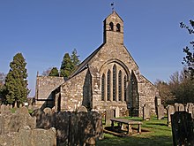
Simonburn is a small human settlement in Northumberland, England.
Simonburn lies to the north of Hadrian's Wall, the most noted Roman monument in Britain. The history of that wall as well as the Roman Stanegate forms the earliest recorded history of the Simonburn vicinity. The length of Hadrian's Wall is 117 kilometres, spanning the width of Britain; the wall incorporates the Vallum, [2] a rearward ditch system, and was constructed chiefly to prevent harrying by small bands of raiders and unwanted immigration from the north, not as a fighting front for a major invasion. [3]
Nunwick Hall is a privately owned 18th-century country house nearby. The house is a Grade II* listed building. [4]
Simonburn Castle was held by the Heron family of Chipchase Castle from the 14th century until it was sold in 1718. The castle was subsequently dismantled by treasure hunters.
Carlisle is a city in Cumbria, England. It is the county town and the administrative centre of the City of Carlisle district. Carlisle is located 8 miles (13 km) south of the Scottish border, and it is often referred to as a "border city". The city is located at the confluence of the rivers Eden, Caldew and Petteril. It is the largest settlement in the county of Cumbria and serves as the administrative centre for both Carlisle City Council and Cumbria County Council. Carlisle is also in the historic county of Cumberland. At the time of the 2001 census, the population of Carlisle was 71,773, with 100,734 living in the wider city. In the 2011 census, the city's population had risen to 75,306, with 107,524 in the wider city.
There are many Roman sites in Great Britain that are open to the public. There are also many sites that do not require special access, including Roman roads, and sites that have not been uncovered.
Haltwhistle is a market town and civil parish in Northumberland, England, ten miles east of Brampton. It had a population of 3,811 at the 2011 Census.
Northumberland, England's northernmost county, is a land where Roman occupiers once guarded a walled frontier, Anglian invaders fought with Celtic natives, and Norman lords built castles to suppress rebellion and defend a contested border with Scotland. The present-day county is a vestige of an independent kingdom that once stretched from Edinburgh to the Humber, hence its name, meaning literally 'north of the Humber'. Reflecting its tumultuous past, Northumberland has more castles than any other county in England, and the greatest number of recognised battle sites. Once an economically important region that supplied much of the coal that powered the industrial revolution, Northumberland is now a primarily rural county with a small and gradually shrinking population.
Ravenglass is a coastal village in the Copeland District in Cumbria, England. It is between Barrow-in-Furness and Whitehaven. Historically in Cumberland, it is the only coastal village in the Lake District National Park. It is located at the estuary of three rivers: the Esk, Mite and Irt.
Housesteads Roman Fort is the remains of an auxiliary fort on Hadrian's Wall, at Housesteads, Northumberland, England, south of Broomlee Lough. The fort was built in stone around AD 124, soon after the construction of the wall began in AD 122 when the area was part of the Roman province of Britannia. Its name has been variously given as Vercovicium, Borcovicus, Borcovicium, and Velurtion. The 18th-century farmhouse Housesteads gives the modern name. The site is owned by the National Trust and is in the care of English Heritage. Finds can be seen at the site, in the museum at Chesters, and in the Great North Museum: Hancock in Newcastle upon Tyne.
Birdoswald Roman Fort was known as Banna in Roman times, reflecting the geography of the site on a triangular spur of land bounded by cliffs to the south and east commanding a broad meander of the River Irthing in Cumbria below.
Segedunum was a Roman fort at modern-day Wallsend, North Tyneside in North East England. The fort lay at the eastern end of Hadrian's Wall near the banks of the River Tyne, forming the easternmost portion of the wall. It was in use as a garrison for approximately 300 years, from around 122 AD, almost up to 400AD. Today, Segedunum is the most thoroughly excavated fort along Hadrian's Wall, and is operated as Segedunum Roman Fort, Baths and Museum. It forms part of the Hadrian's Wall UNESCO World Heritage Site.
Burgh by Sands is a village and civil parish in the City of Carlisle district of Cumbria, England, situated near the Solway Firth. The parish includes the village of Burgh by Sands along with Longburgh, Dykesfield, Boustead Hill, Moorhouse and Thurstonfield. It is notable as the site of the first recorded North African (Moorish) military unit in Roman Britain, garrisoning the frontier fort of Aballava on Hadrian's Wall in the 3rd century AD. It is also where Edward I of England died in 1307.
Magnis or Magna or Magnae Carvetiorum was a Roman fort on Hadrian's Wall in northern Britain. Its ruins are now known as Carvoran Roman Fort and are located near Carvoran, Northumberland, in northern England. It is thought to have been sited with reference to the Stanegate Roman road, before the building of Hadrian's Wall, to which it is not physically attached. In fact the Vallum ditch unusually goes north of the fort, separating it from the Wall.
Gilsland is a village in northern England about 20 miles (32 km) west of Hexham, and about 18 miles (29 km) east of Carlisle, which straddles the border between Cumbria and Northumberland. The village provides an amenity centre for visitors touring Hadrian's Wall and other features of historical interest in this area of rugged Border country, popularised by the Romantic novelist Sir Walter Scott.
Featherstone Castle, a Grade I listed building, is a large Gothic style country mansion situated on the bank of the River South Tyne about 3 miles (5 km) southwest of the town of Haltwhistle in Northumberland, England.
Pons Aelius, or Newcastle Roman Fort, was an auxiliary castra and small Roman settlement on Hadrian's Wall in the Roman province of Britannia Inferior, situated on the north bank of the River Tyne close to the centre of present-day Newcastle upon Tyne, and occupied between the 2nd and 4th centuries AD.
Nunwick Hall is a privately owned 18th-century country house near Simonburn, Northumberland in North East England. The estate has been the home of the Allgood family since the 17th century. The house is a Grade II* listed building but is not open to the public.
Aballava or Aballaba was a Roman fort on Hadrian's Wall, between Petriana (Stanwix) to the east and Coggabata (Drumburgh) to the west. It is about one and a half miles south of the Solway Firth, and its purpose was to guard the south end of two important Solway fords, the Peat Wath and the Sandwath, which were also to become favourite routes for medieval border raiders.
Hadrian's Wall, also known as the Roman Wall, Picts' Wall, or Vallum Hadriani in Latin, is a former defensive fortification of the Roman province of Britannia, begun in AD 122 in the reign of the emperor Hadrian. Running "from Wallsend on the River Tyne in the east to Bowness-on-Solway in the west", the Wall covered the whole width of the island. In addition to the wall's defensive military role, its gates may have been customs posts.
Bewcastle Roman Fort was built to the north of Hadrian's Wall as an outpost fort possibly intended for scouting and intelligence. The remains of the fort are situated at the village of Bewcastle, Cumbria, 7 miles (11 km) to the north of the Roman fort at Birdoswald, on Hadrian's Wall.
The Antonine Wall, known to the Romans as Vallum Antonini, was a turf fortification on stone foundations, built by the Romans across what is now the Central Belt of Scotland, between the Firth of Forth and the Firth of Clyde. Built some twenty years after Hadrian's Wall to the south, and intended to supersede it, while it was garrisoned it was the northernmost frontier barrier of the Roman Empire. It spanned approximately 63 kilometres and was about 3 metres high and 5 metres wide. Lidar scans have been carried out to establish the length of the wall and the Roman distance units used. Security was bolstered by a deep ditch on the northern side. It is thought that there was a wooden palisade on top of the turf. The barrier was the second of two "great walls" created by the Romans in Great Britain in the second century AD. Its ruins are less evident than those of the better-known and longer Hadrian's Wall to the south, primarily because the turf and wood wall has largely weathered away, unlike its stone-built southern predecessor.
Milecastle 7 was a milecastle of the Roman Hadrian's Wall. The milecastle itself has not been discovered by archaeologists and its presumed location lies beneath a modern housing development. Roman finds have been made in the area and the associated structure of Turret 7B is a significant surviving structure of the wall.
Milecastle 29 was a milecastle of the Roman Hadrian's Wall. Its remains exist as a mutilated earth platform accentuated by deep robber-trenches around all sides, and are located beside the B6318 Military Road. Like Milecastles 9, 23, 25, and 51, a ditch has been identified around the Milecastle, and is still visible to a small extent. It has been postulated that this was as a result of the need for drainage on the site.