Carlisle is a cathedral city in the ceremonial county of Cumbria in England. It is the administrative centre of Cumberland Council which covers an area similar to the historic county of Cumberland.
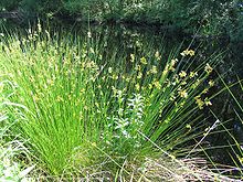
The Cumbria Way is a linear 112-kilometre (70-mile) long-distance footpath in Cumbria, England. The majority of the route is inside the boundaries of the Lake District National Park. Linking the two historic Cumbrian towns of Ulverston and Carlisle, it passes through the towns of Coniston and Keswick. The route cuts through Lakeland country via Coniston Water, Langdale, Borrowdale, Derwent Water, Skiddaw Forest and Caldbeck. It is a primarily low-level route with some high-level exposed sections.

The City of Carlisle was a local government district of Cumbria, England, with the status of a city. It was named after its largest settlement, Carlisle, but covered a far larger area which included the towns of Brampton and Longtown, as well as outlying villages including Dalston, Scotby and Wetheral. In 2011 the district had a population of 107,524, and an area of 1,039.97 square kilometres (402 sq mi).

Skiddaw is a mountain in the Lake District National Park in England. Its 931-metre (3,054 ft) summit is the sixth-highest in England. It lies just north of the town of Keswick, Cumbria, and dominates the skyline in this part of the northern lakes. It is the simplest of the Lake District mountains of this height to ascend and, as such, many walking guides recommend it to the occasional walker wishing to climb a mountain. This is the first summit of the fell running challenge known as the Bob Graham Round when undertaken in a clockwise direction.
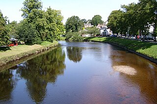
The River Eden is a river that flows through the Eden District of Cumbria, England, on its way to the Solway Firth.

Knott is a mountain in the northern part of the English Lake District. It is the highest point of the Back o'Skiddaw region, an area of wild and unfrequented moorland to the north of Skiddaw and Blencathra. Other tops in this region include High Pike, Carrock Fell and Great Calva. The fell's slopes are mostly smooth, gentle, and covered in grass, with a few deep ravines. It stands a long way from a road and requires a long walk across the moor top get to it; this, as well as the fact that it is hidden from the rest of the Lake District by the two aforementioned giants, make it one of the most unfrequented tops in the Lakes. When it is climbed it is most often from Mungrisdale or from the north via Great Sca Fell. The word Knott is of Cumbric origin, and means simply "hill".

Carrock Fell is a fell in the English Lake District, situated in the northern region of the national park, 8 miles north-east of Keswick.

High Pike is a fell in the northern part of the English Lake District, it is located 4+1⁄2 kilometres south of Caldbeck. It has a height of 658 metres (2,159 ft) and is the most northerly of the Lakeland fells over 2000 feet. It is a large fell with its northern slopes falling away towards the lower ground between Caldbeck and Carlisle. Like the neighbouring Carrock Fell it has been extensively mined and the wealth created by the abundant variety of minerals on High Pike led to the saying "Caldbeck fells are worth all England else". This fell should not be confused with another Lake District High Pike situated in Scandale near Ambleside.

Great Calva is a fell in the Lake District, England. It is in the Northern Fells, lying roughly at the centre of this region of high ground. As a result, it is distant from roads and quite remote by Lakeland standards. Great Calva stands at the head of a major geological fault running through the centre of the Lake District, and so from the summit it is possible to see all the way south over Thirlmere. The subsidiary summit of Little Calva lies to the west.

Bowscale Fell is a hill in the English Lake District. It rises above the village of Mungrisdale in the Northern Fells. Bowscale Fell stands at the extreme north east the Blencathra group, connected to this higher fell by the intervening Bannerdale Crags. In common with many fells the western slopes are smooth and convex while the eastern side exhibits crags.

Lonscale Fell is a hill in the English Lake District. Its pointed second top is instantly recognisable, standing at the eastern end of the Skiddaw massif. The fell is easily climbed from Keswick or from Skiddaw House to the north. Although now primarily a sheep pasture, it once saw considerable mining activity beneath the long eastern wall of crag.

The Northern Fells are a mountain range in the English Lake District. Including Skiddaw, they occupy a wide area to the north of Keswick. Smooth, sweeping slopes predominate, with a minimum of tarns or crags. Blencathra in the south-east of the group is the principal exception to this trend.

Uxelodunum was a Roman fort. It was the largest fort on Hadrian's Wall, and is now buried beneath the suburb of Stanwix, in Carlisle, Cumbria, England.

Sebergham is a small village and civil parish in the English county of Cumbria. It is located on the B5305, south of Carlisle and south-east of Wigton. The civil parish population at the 2011 Census was 365.

Mosedale is a hamlet and former civil parish, now in the parish of Mungrisdale in the Eden district, in the county of Cumbria, in the north west of the English Lake District. It is on the River Caldew, north east of Bowscale Fell and south east of Carrock Fell, about one mile north of Mungrisdale. In 1931 the parish had a population of 49. In the 2011 United Kingdom census the parish of Mungrisdale, comprising eight hamlets including Mosedale, had a population of 297.

In a charter of c.957 AD, King Eadwig granted twenty hides of land to Abingdon Abbey.
aet Hengestesige , and aet Seofecanwyrthe , and aet Wihtham