Cumbria Way

Last updated

Cumbria Way
Cumbria Way logo.svg
Waymarker and logo
Length112 km (70 mi)
Location Cumbria, England
Established1970s
Trailheads Ulverston
Carlisle
UseHiking
Elevation
Elevation gain/loss2,973 m (9,754 ft)
Highest point High Pike, 658 m (2,159 ft)
Hiking details
Trail difficultyChallenging
SeasonAll year
Waymark Name on green disc
Website www.cumbriawaywalk.info
Trail map

Contents

BSicon fENDEa.svg
Carlisle
BSicon fHST.svg
Caldbeck
BSicon fGIP.svg
High Pike
BSicon fBHF.svg
Keswick
BSicon fHST.svg
Great Langdale
BSicon fHST.svg
Coniston
BSicon fENDEe.svg
Ulverston

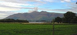
The Cumbria Way is a linear 112-kilometre (70-mile) long-distance footpath in Cumbria, England. [1] [2] [3] The majority of the route is inside the boundaries of the Lake District National Park. Linking the two historic Cumbrian towns of Ulverston and Carlisle, it passes through the towns of Coniston and Keswick. The route cuts through Lakeland country via Coniston Water, Langdale, Borrowdale, Derwent Water, Skiddaw Forest and Caldbeck. It is a primarily low-level route with some high-level exposed sections. [4]

History

The Cumbria Way was originally devised in the 1970s by local Ramblers Association members. The waymarking of the entire route was completed by volunteers and national park staff in May 2007. [5]

Route

The route can be walked in either direction but is described here as south to north beginning at the trailhead of Ulverston and ending in Carlisle.

Stage 1: Ulverston to Coniston

Coniston Water seen from the North Coniston Water from Holme Fell.jpg
Coniston Water seen from the North

The route leaves the urban area of Ulverston, birthplace of Stan Laurel, and heads north towards the village of Gawthwaite and the boundary of the Lake District National Park. The trail, which consists primarily of field paths at this stage, leads to the settlement of Sunny Bank and the shore of Coniston Water, the western shoreline of which is followed before reaching the settlement of Coniston. [6] Grizedale Forest is visible to the east of the lake with Coniston Old Man and Dow Crag being visible to the west on approach to Coniston. This stage is approximately 24 km (15 mi) in length.

Stage 2: Coniston to Langdale

Langdale Pikes Langdale Pikes In English LakeDistrict.jpg
Langdale Pikes

The route leaves Coniston heading in a NNW direction through woodland towards Tarn Hows. The way involves some road walking as it passes through the villages of Colwith and Skelwith Bridge. The Langdale Pikes soon become visible as the route leaves Skelwith Bridge in a NNE direction, passing Elter Water before entering the Great Langdale valley. [7] This stage is approximately 17.5 km (11 mi) in length.

Stage 3: Langdale to Keswick

Derwent Water seen from Castle Crag Derwent water from castle crag (229492456).jpg
Derwent Water seen from Castle Crag

The route leaves Langdale and travels alongside Mickleden beck, with the mountain of Bow Fell to the west and Langdale Pikes to the east. After a significant gain in elevation the route crosses Stake Pass before descending via Langstrath beck and turning towards the villages of Stonethwaite and Rosthwaite. The route subsequently follows the River Derwent before reaching Derwent Water where it follows the shoreline path to reach the town of Keswick. The mountains Skiddaw and Blencathra may be visible to the north. [8] This stage is approximately 24 km (15 mi) in length.

Stage 4: Keswick to Caldbeck

Skiddaw seen from Borrowdale Skiddaw borrowdale.jpg
Skiddaw seen from Borrowdale

After some urban walking on the exit from Keswick, the route crosses the A591 road before ascending past Latrigg towards Skiddaw House Youth Hostel. After crossing the area of fells known as Back o'Skiddaw the route passes High Pike and the Caldbeck Fells before descending towards the village of Caldbeck. [9] This stage is approximately 22.5 km (14 mi) in length.

Stage 5: Caldbeck to Carlisle

Carlisle Carlisle from the castle.jpg
Carlisle

After leaving the village of Caldbeck this final low-level section of the route follows the course of the River Caldew to the city of Carlisle, Cumbria's county town. The route passes through the villages of Sebergham, Buckabank and Dalston primarily following woodland and farmland public footpaths and bridleways. [10] This stage is approximately 24 km (15 mi) in length.

Geology and biology

Flora and fauna

The tarns encountered on the route provide a habitat for a wide range of species including vendace, charr, crayfish and schelly. [11]

The red squirrel can be found in woodland encountered on the route. [12]

Red squirrel Eichhornchen Dusseldorf Hofgarten edit.jpg
Red squirrel

The high precipitation in the ancient woodland encountered throughout the route provides a favourable habitat for mosses, liverworts, ferns and lichens. The boggy areas encountered, particularly on the high-level parts of the route, provide a habitat for carnivorous plants including sundew and butterwort. [13]

Connecting trails

The route connects with the Allerdale Ramble, Cumbria Coastal Way, Coast to Coast Walk, Hadrian's wall path, Cistercian Way, Eden Way and Windermere Way.

Further reading

The following Ordnance Survey maps cover the route:

The following guidebooks detail the route:

Related Research Articles

Cumbria Ceremonial county of England

Cumbria is a ceremonial and non-metropolitan county in North West England. The county and Cumbria County Council, its local government, came into existence in 1974 after the passage of the Local Government Act 1972. Cumbria's county town is Carlisle, in the north of the county. The only other major urban area is Barrow-in-Furness on the south-western tip of the county.

Lake District Mountainous region in North West England

The Lake District, also known as the Lakes or Lakeland, is a mountainous region in North West England. A popular holiday destination, it is famous for its lakes, forests and mountains, and its associations with William Wordsworth and other Lake Poets and also with Beatrix Potter and John Ruskin. The Lake District National Park was established in 1951 and covers an area of 2,362 square kilometres (912 sq mi). It was designated a UNESCO World Heritage Site in 2017.

Keswick, Cumbria Town and parish in the English Lake District National Park

Keswick is an English market town and a civil parish, historically in Cumberland, and since 1974 in the Borough of Allerdale in Cumbria. Lying within the Lake District National Park, Keswick is just north of Derwentwater and is 4 miles (6.4 km) from Bassenthwaite Lake. It had a population of 5,243 at the 2011 census.

A595 road Road in Cumbria, England

The A595 is a primary route in Cumbria, in Northern England that starts in Carlisle, passes through Whitehaven and goes close to Workington, Cockermouth and Wigton. It passes Sellafield and Ravenglass before ending at the Dalton-in-Furness by-pass, in southern Cumbria, where it joins the A590 trunk road. The road is mostly single carriageway, apart from in central Carlisle, where it passes the castle as a busy dual carriageway road named Castle Way, and prior to that as Bridge Street and Church Street, where it passes close to the McVitie's or Carr's biscuit factory. The Lillyhall bypass is also dual carriageway.

Skiddaw Mountain in the Lake District, England

Skiddaw is a mountain in the Lake District National Park in England. Its 931-metre (3,054 ft) summit is the sixth-highest in England. It lies just north of the town of Keswick, Cumbria, and dominates the skyline in this part of the northern lakes. It is the simplest of the Lake District mountains of this height to ascend and, as such, many walking guides recommend it to the occasional walker wishing to climb a mountain. This is the first summit of the fell running challenge known as the Bob Graham Round when undertaken in a clockwise direction.

Knott, Caldbeck

Knott is a mountain in the northern part of the English Lake District. It is the highest point of the Back o'Skiddaw region, an area of wild and unfrequented moorland to the north of Skiddaw and Blencathra. Other tops in this region include High Pike, Carrock Fell and Great Calva. The fell's slopes are mostly smooth, gentle, and covered in grass, with a few deep ravines. It stands a long way from a road and requires a long walk across the moor top get to it; this, as well as the fact that it is hidden from the rest of the Lake District by the two aforementioned giants, make it one of the most unfrequented tops in the Lakes. When it is climbed it is most often from Mungrisdale or from the north via Great Sca Fell. The word Knott is of Cumbric origin, and means simply "hill".

Blindcrake Human settlement in England

Blindcrake is a village and civil parish within the Isel Valley, in the Lake District National Park, in Cumbria, England, historically part of Cumberland. According to the 2001 census it had a population of 287, increasing to 348 at the 2011 Census. The parish includes Blindcrake village and the hamlets of Redmain, Isel and Sunderland.

Latrigg Mountain in United Kingdom

Latrigg is one of the lowest fells in the Lake District in North West England, but is a popular climb due to its convenient location overlooking the town of Keswick and the beautiful views down the valley of Borrowdale from the summit. It is the least mountainous of the Skiddaw fells, the summit being almost entirely devoid of rock. The slopes of Latrigg are partially wooded, and logging work is currently being undertaken. One lone tree just south of the summit is prominently viewed in silhouette when approaching Keswick from the west along the A66. It also has petrified trees on top.

Grisedale Pike

Grisedale Pike is a fell in the Lake District, Cumbria, England, situated 4.5 miles (7.2 km) west of the town of Keswick in the north-western sector of the national park. At a height of 791 m (2593 feet) it is the 40th-highest Wainwright in the Lake District; it also qualifies as a Hewitt, Marilyn and Nuttall. Grisedale Pike presents a striking appearance when viewed from the east, particularly from the vicinity of Keswick. It possesses two subsidiary summits: one unnamed ; the other Hobcarton End.

Black Fell (Lake District)

Black Fell is a fell in the English Lake District. It rises to the north of Tarn Hows, between Coniston and Hawkshead.

Hesket Newmarket Human settlement in England

Hesket Newmarket is a small village in Cumbria, England, historically within Cumberland. It is on the opposite side of Skiddaw to Keswick within the Lake District National Park.

Northern Fells

The Northern Fells are a mountain range in the English Lake District. Including Skiddaw, they occupy a wide area to the north of Keswick. Smooth sweeping slopes predominate with a minimum of tarns or crags. Blencathra in the south east of the group is the principal exception to this trend.

Cumbria Fire and Rescue Service Fire and rescue service in north west England

Cumbria Fire and Rescue Service is the statutory fire and rescue service for the Shire county of Cumbria, England. Since 2012, the headquarters for the service's 38 fire stations are at Penrith next to the headquarters of Cumbria Constabulary.

Stagecoach Cumbria & North Lancashire Bus operator

Stagecoach Cumbria & North Lancashire is a major operator of bus services in North West England. It is a subsidiary of the Stagecoach Group, and has its origins in the purchase of Cumberland in 1987 and Ribble in 1988 from the National Bus Company. The head office of Stagecoach Cumbria & North Lancashire is in Carlisle. It was previously known as Stagecoach North West until 1 September 2011, when Stagecoach Merseyside joined Preston and Chorley depots to form Stagecoach Merseyside & South Lancashire.

Stagecoach bus route 555

Stagecoach bus route 555 links Lancaster in Lancashire with towns and villages in the Lake District in North West England. The route is approximately 45 miles long and takes on average 2 hours and 40 minutes to complete. It is one of the longest routes as well as one of the most scenic bus routes in England. The route is operated by Stagecoach Cumbria & North Lancashire and was previously operated by Ribble Motor Services.

References

  1. "Cumbria Way". Long Distance Walkers Association . Retrieved 29 January 2021.
  2. Gillham, John (11 February 2015). The Cumbria Way (First ed.). Cicerone Press. ISBN   9781852847609 . Retrieved 29 January 2021.
  3. "The Cumbria Way Walk". The Cumbria Way Walk. Retrieved 29 January 2021.
  4. "Paths. Recreational Route: Cumbria - Cumbria Way". Ramblers Association. Archived from the original on 16 May 2008. Retrieved 17 May 2008.
  5. Crawford, S (30 May 2007). "Marking the way for walkers". Cumberland News. Retrieved 17 May 2008.[ permanent dead link ]
  6. "STAGE 1 Ulverston to Coniston" (PDF). Ulverston Tourist Information Centre. Archived from the original on 13 April 2005. Retrieved 29 January 2021.CS1 maint: unfit URL (link)
  7. "STAGE 2 Coniston to Langdale" (PDF). Ulverston Tourist Information Centre. Archived from the original on 13 April 2005. Retrieved 29 January 2021.CS1 maint: unfit URL (link)
  8. "STAGE 3 Langdale to Keswick" (PDF). Ulverston Tourist Information Centre. Archived from the original on 13 April 2005. Retrieved 29 January 2021.CS1 maint: unfit URL (link)
  9. "STAGE 4 Keswick to Caldbeck" (PDF). Ulverston Tourist Information Centre. Archived from the original on 13 April 2005. Retrieved 29 January 2021.CS1 maint: unfit URL (link)
  10. "STAGE 5 Caldbeck to Carlisle" (PDF). Ulverston Tourist Information Centre. Archived from the original on 21 December 2005. Retrieved 29 January 2021.CS1 maint: unfit URL (link)
  11. "Lake District Special Properties". The Lake District National Park Authority. Archived from the original on 10 May 2008. Retrieved 17 May 2008.
  12. "Wildlife". Lake District National Park . Retrieved 29 January 2021.
  13. "Cumberland Mountain Flowers". Flora of the Fells. Archived from the original on 20 July 2008. Retrieved 17 May 2008.