Relief map of Skiddaw Group SSSI including unit numbers
Skiddaw Group SSSI is a site of special scientific interest in the Lake District High Fells, England. Its shape is approximately an irregular circle centred near Great Calva, with an area of 10,256.3 hectares (39.600sqmi).[3] The high ground creates a watershed between the Caldew Operational Catchment with water flowing north towards Carlisle, and the Ellen and West Coast and Derwent Operational Catchments flowing towards the west coast at Workington and Maryport.[4][5] The area includes the Skiddaw Forest nature reserve.
The SSSI is divided into a patchwork of "units" which are used as the level of geographic detail for reporting overall features and conditions.[6] Each unit is identified by the Ordnance Survey grid reference at the centre of the unit, its area in hectares, the date it was last surveyed, and the drainage catchment it is located in.[b] For example Bassenthwaite Common, which is unit 27, is nearly 700ha (2.7sqmi) centred at NY252299 in the Dash beck catchment. The habitat is there is dwarf shrub heath which, when surveyed in November 2010, was in an "unfavourable – recovering" condition.[3]
Skiddaw Forest
Skiddaw Forest is the ancient name of an expanse of land to the east of Skiddaw summit, with the word "forest" referring here to a medieval pattern of land ownership.[7][8] In 2024 the forest area within the Underskiddaw civil parish area,[c] essentially SSSI units 30 and 31 together with the summits of Skiddaw (unit 16) and Great Calva (unit 17), was purchased by Cumbria Wildlife Trust as a 1,200ha (4.6sqmi) nature reserve.[9][10] The long term biodiversity and rewilding goals include encouraging tree growth to create tracts of temperate rainforest, and restoring peatlands.[11]
Unit 30, Skiddaw Forest West, was assessed in 2021 as having "favourable" conditions for invertebrate and breeding bird features, but "unfavourable – recovering" blanket bog and upland dry heath habitats.[12] Conditions in unit 31, Skiddaw Forest East were assessed as "favourable" in 2021.[13]
The northern part of the SSSI includes several sites of former mines, noted today for the presence of minerals in spoil heaps and erosion sites.[14][15][16]
Spoil heaps at Red Gill Mine (NY295347, unit 26) include rare, crystallised lead sulphates, carbonates and phosphates. An adjacent mine at Roughtongill (NY302344, unit 23) reveals supergene minerals including copper and zinc varieties.[3] English Heritage undertook a detailed survey of Roughtongill in 2001 and reported on its history and archaeology.[14]
Dry Gill Lead Mine (NY324345, unit 24) has a unique form of mimetite, known as 'campylite'. Natural England surveyed the site in 2022 and found the exposed mineral veins had been damaged by collectors in the past but not recently. Burdell Gill (NY307324, unit 20) "is of national importance as the only relatively abundant source of the rare arsenic mineral, pharmacosiderite, in Britain."[3] A vein at Wet Swine Gill (NY314321) includes stibnite and fuloppite but the 2022 survey (SSSI Unit 2) found that geological specimen collecting continued to cause damage. In the Carrock Mine – Brandy Gill spoil heaps (NY322338) the mineralisation is tungsten-rich.[3] The Carrock Tungsten Mine (NY323329)[17] and Carrock End Copper Mine[16] are Scheduled Monuments.[18][19]
There are other mine sites not mentioned in the SSSI designation, such as in the wider Grainsgill area (NY327327),[20] near to Carrock mine. A 2021 survey in that area (SSSI unit 8) observed "Ordovician igneous geological features".[3] Breafell lead mine (NY299357, unit 26) was downstream from Redgill and Roughtongill on the Dale Beck, a tributary of the Whelpo. Driggith lead mine[21] was downstream from Drygill mine. Sandbeck lead and copper mine (NY332362, unit 24/25) was 1,800 metres (1.1mi) north east of High Pike.[15]
Caldew operational catchment
House at the foot of Carrock Fell
The Skiddaw Group SSSI includes the headwaters of the Whelpo (Cald) Beck and Caldew (upper) 'water bodies' (catchments).[5] These are part of the Caldew operational catchment.[d]
The Whelpo Beck catchment includes Brae Fell (586m (1,923ft), unit 26), and the former mine sites at Red Gill and Roughtongill (units 26 and 23).[3] When surveyed by Natural England in 2010, both mine sites (SSSI Units 3 and 11) were showing some signs of collector activity and erosion but were not considered to be under threat. The "dwarf shrub heath" habitats were surveyed in 2022 (SSSI units 23 – Roughton Gill; 25 – Caldbeck North; and 26 – Brae Fell). They were all depleted by heavy grazing. Patches of bilberry (Vaccinium spp.) were observed on Brae Fell.[3]
The Caldew (upper) catchment accounts for 40% of the total area of the SSSI and the majority of its assessment units.[5][22] The River Caldew flows there between the Blencathra uplands in the south-east of the SSSI, and the Skiddaw and Caldbeck Fells uplands to the west and north. The catchment includes Great Calva (690m (2,260ft), unit 17) and Carrock Fell (661m (2,169ft), units 22 and 24). Around the edge of the catchment, Lonscale Fell, Skiddaw, Skiddaw Little Man, and Bowscale Fell form watersheds with the catchments in the Derwent Operational Catchment area.[4] It includes the former mine sites at Dry Gill Mine, Carrock Mine-Brandy Gill, Burdell Gill and Wet Swine Gill.[3] It also includes Bowscale Tarn (NY336313, unit 13), one of two glacial tarns in the SSSI,[3] where quillwort (Isoetes lacustris), shoreweed (Littorella uniflora) and water lobelia (Lobelia dortmanna) have been found.
Heather moor predominates on sloping ground north and west of the River Caldew across several catchments. The east-facing slopes of Skiddaw, Little Man and Jenkin Hill exhibit degraded moss heath. Common juniper (Juniperus communis) scrub, which is a nationally rare habitat, is most extensive on the steep, rocky south-facing slopes of Carrock Fell (NY342336).[3]
Shoreweed
Water lobelia
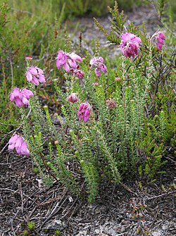
Common juniper
Derwent management catchment
The Skiddaw Group SSSI includes headwaters of the Derwent management catchment,[d] consisting of the Ellen (upper) catchment, which flows towards Maryport, and four catchments flowing towards Workington:[4]
Dash Beck
Derwent US Bassenthwaite Lake and Derwent DS Bassenthwaite[e]
Glenderaterra Beck
Glenderamackin u/s Troutbeck and Glenderamackin (Greta)[e]
The Ellen (upper) catchment is at the north of the SSSI in the Uldale Fells. It is bounded by Longlands Fell, Lowthwaite Fell, Little and Great Sca Fells, Meal Fell and Great Cockup. Great Cockup (NY270334, unit 18) is known for fossils of dendroid graptolites. Tremadoc–Llanvirn geology[23] is visible in the crags around Great Cockup. The heathland lacks species diversity and shows signs of heavy grazing.[3] For catchment management purposes, the main water body is the Dale Gill which rises between Great and Little Cockup. The River Ellen's headwaters, with numerous small tributaries, drain the Uldale Fells and join Dale Gill beyond the SSSI boundary.
Whitewater Dash
The SSSI includes the headwaters of the Dash Beck catchment, including short lengths of Dash Beck itself, and of several of its tributaries. The part of the catchment within the SSSI stretches from Great Sca Fell in the north-east to Ullock Pike7km (4.3 miles) away in the south-west, with the Whitewater Dash waterfall (NY272313) where the beck crosses the catchment midway between the two.[24] The area includes Bakestall where crowberry (Empetrum nigrum) is the dominant dwarf-shrub. It also includes Broad End which has "the best developed example [of montane moss-grass heath in West Cumbria] at about 700m (2,300ft)" elevation. There are two monitoring units in the Dash beck catchment: Uldale South (SSSI Unit 19, NY282322) has low species diversity with some areas recovering; Uldale North (SSSI Unit 18, NY272342) includes heather (Calluna vulgaris), bilberry (Vaccinium spp), crowberry (Empetrum nigrum) and cross-leaved heath (Erica tetralix) but the sites are fragmented where they should be continuous.[3] In the north-east of the catchment, the watershed is marked by Knott, Great Sca Fell, Meal Fell, and Great Cockup.
The Glenderaterra Beck catchment includes Lonscale Fell (SSSI Unit 29, NY289269, surveyed 2024) and Blencathra North West (SSSI Unit 32, NY311274, surveyed 2019). Lonscale Fell ecology included some bracken and limited cover of ericoid shrubs in its "acidic grassland with bilberry" habitats. Blencathra North West had "blanket bog with abundant hare's-tail cottongrass (Eriophorum vaginatum) and deergrass (Trichophorum cespitosum) over locally abundant bog mosses".[3]
There is a small area of common juniper (Juniperus communis) scrub in Glenderamackin u/s Troutbeck[e] on The Tongue (NY347302). The same catchment includes Scales Tarn (Blencathra), one of the two glacial tarns in the SSSI. The tarn has "low nutrient levels and [is] inherently species-poor." The area around the tarn has in the past been subject to heavy grazing. Mungrisdale East (SSSI Unit 35, NY343297) includes hare's-tail cottongrass (Eriophorum vaginatum), abundant sphagnum moss (Sphagnum spp.) and a good population of serrated wintergreen (Orthilia secunda). Young Wood (SSSI Unit 38, NY350307) is protected by fencing to keep grazing animals away and the oak woodland is recovering.[3][25][26]
Local Nature Recovery Strategies (LNRS) are a UK government response to declining biodiversity.[34] The local strategies are established to agree priorities and propose actions to reverse the decline. The Cumbria Local Nature Recovery Strategy was developed following initial "Vision and Priority" workshops held in March 2024,[35] with further consultation during 2025. The strategy includes the development of an interactive habitat map.[36] The map shows where habitats need enhancing or, in worse cases, restoring. For example SSSI Unit 22 "Carrock Fell" includes an area of "moorland, heathland and montaine" habitat which would benefit from enhancement. However the south west edge of the unit is in worse condition so would need restoration.[36]
United Kingdom Biodiversity Action Plan
Blanket bog on Mungrisdale Common
The United Kingdom Biodiversity Action Plan identified a range of priority habitats which occur across the UK. The Skiddaw Group SSSI has large areas of grass moorland and upland heath, together with more fragmented areas of blanket bog.[37][38] For example, the upland areas around Bannerdale Beck (SSSI Unit 35) contain 69 hectares (0.27sqmi) of blanket bog, split across several smaller sites. More detailed mapping from DEFRA[39] and the UK government open data resource[40] shows the same areas of blanket bog but additionally shows areas where the habitat could be restored, where it could potentially be created, and where smaller areas could be used to re-join existing fragmented ones.[f]
↑In the UK, SSSIs are mostly categorised under IUCN category IV,[1][2] with the future potential to classify primarily geological SSSIs in category III.[1] A few are in category I.[2]
↑Units are not catchment-based. The unit boundaries do not precisely follow catchment boundaries so the catchment name associated with the unit is indicative only.
12Natural England groups catchments ('Water Bodies') into 'operational catchments'. Those are grouped into 'management catchments', which are grouped into 'river basin districts'.
123In these catchment names, US and u/s mean "upstream of"; DS is "downstream of"
↑Winchester, Angus (2000). The Harvest of the Hills: Rural Life in Northern England and the Scottish Borders, 1400-1700. Keele University Press. pp.10, 14. ISBN978-1853312397. [Forests here were] the upland portions of great baronial estates anchored in the surrounding lowlands, a relationship seen particularly clearly in the Lake District. Their status as forest placed the uplands directly under the control of great feudal landowners.
↑Liddell, H.W. (1966). "The private forests of S.W. Cumberland"(PDF). Transactions of the Cumberland and Westmorland Antiquarian and Archaeological Society. 66: 110.
12Loughlin, S.C. (1999). "Chapter 4: Lake District and northern England"(PDF). Geological Conservation Review. 17: Caledonian Igneous Rocks of Great Britain. Grainsgill, Caldew valley, GCR ID: 1409.
↑"SSSI unit numbers". Magic Map Application. Landmark Solutions. Retrieved 4 October 2025.
12Young, B. (2010). "Chapter 2 The Lake District"(PDF). In Bevins, R.E.; Young, B.; Mason, J.S.; Manning, D.A.C.; Symes, R.F (eds.). Mineralization of England and Wales. Geological Conservation Review. Vol.36. Peterborough: JNCC.
↑"Dash Beck Water Body". Catchment Data Explorer. Environment Agency. Retrieved 13 May 2025.
↑Wallace, Carrie; Atkins, Roger (2013). "Young Wood: a woodland beyond the edge"(PDF). In Rotherham, Ian D.; Handley, Christine; Agnoletti, Mauro; Samojlik, Tomasz (eds.). Trees beyond the wood: an exploration of concepts of woods, forests and trees. Sheffield, UK: Wildtrack Publishing. pp.311–332.
↑Owen, A.W.; Rushton, A.W A. "Chapter 11: Arenig to Ashgill of northern England"(PDF). In Rushton, A.W.A.; Owen, A.W.; Owens, R.M.; Prigmore, J.K. (eds.). British Cambrian to Ordovician Stratigraphy. JNCC. p.262–264.
This page is based on this Wikipedia article Text is available under the CC BY-SA 4.0 license; additional terms may apply. Images, videos and audio are available under their respective licenses.


 Shoreweed
 Water lobelia
 Common juniper