
The River Rother, a waterway in the northern midlands of England, gives its name to the town of Rotherham and to the Rother Valley parliamentary constituency. It rises in Pilsley in Derbyshire and flows in a generally northwards direction through the centre of Chesterfield, where it feeds the Chesterfield Canal, and on through the Rother Valley Country Park and several districts of Sheffield before joining the River Don at Rotherham in Yorkshire. Historically, it powered mills, mainly corn or flour mills, but most had ceased to operate by the early 20th century, and few of the mill buildings survive.
The River Wyre, in Lancashire, England, flows into the Irish Sea at Fleetwood. It is 28 miles (45 km) long and has a sheltered estuary which penetrates deep into the Fylde peninsula.

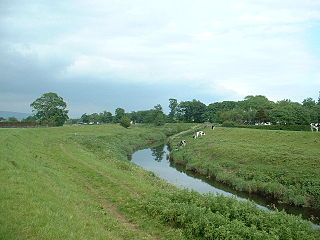
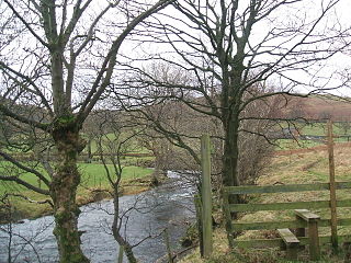
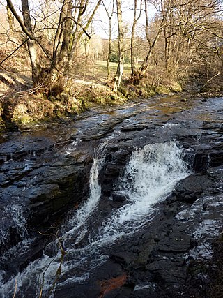
The River Kent is a short river in the county of Cumbria in England. It originates in hills surrounding Kentmere, and flows for around 20 miles (32 km) into the north of Morecambe Bay. The upper reaches and the western bank of the estuary are located within the boundaries of the Lake District National Park. The river flows in a generally north to south direction, passing through Kentmere, Staveley, Burneside, Kendal and Sedgwick. Near Sedgwick, the river passes through a rock gorge which produces a number of low waterfalls. This section is popular with kayakers as it offers high quality whitewater for several days after rain. The village of Arnside is situated on the east bank of the Kent estuary, just above Morecambe Bay, and a tidal bore known as the Arnside Bore forms in the estuary at this point on high spring tides.

The River Irt is a river in the county of Cumbria in northern England. It flows for approximately 22 kilometres (14 mi) from its source in Wast Water to its estuary at Ravenglass.

The River Winster is a river in the English county of Cumbria. The Winster was the boundary between the ancient counties of Lancashire and Westmorland. It has a relatively small catchment area; other streams flow parallel to it on either side.
St. John's Beck is a river in the Lake District of Cumbria, England.

Peasey Beck is a 19.6-kilometre-long (12.2 mi) beck flowing through Cumbria, England. It rises on Lambrigg Fell where it is known as the Sparishaw Beck, flows through Killington Reservoir and converges with Stainton Beck to form the River Bela at Milnthorpe. Prior to 1913, it was known as the River Beela throughout its length.

The River Waver is a river in Cumbria, England. The river rises at Wavergillhead . It is fed by the northwards flowing Thornthwaite Beck and Pow Gill either side of Bolton Wood Lane. The "Little Waver", rising at Catlands Hill, joins at Waterside near Woodrow. The river then takes a northward course via Waverton and Waverbridge, both of which are named for the river, before turning sharply westward at Abbeytown. The river then goes north, running into Moricambe Bay, an inlet of the Solway Firth.

Kershope Burn is a small river; a tributary of both the Liddel Water and the River Esk; its final destination is the Solway Firth. The early stages begin in the Border Forest, from where it flows in a south westerly direction, followed in its entirety by the border between England and Scotland.

The River Lyvennet is a river flowing through the county of Cumbria in England.
Artle Beck is a minor river of Lancashire, England.

In Yorkshire there is a very close relationship between the major topographical areas and the geological period in which they were formed. The Pennine chain of Hills in the west is of Carboniferous origin. The central vale is Permo-Triassic. The North York Moors in the north-east of the county are Jurassic in age while the Yorkshire Wolds to the south east are Cretaceous chalk uplands. The plain of Holderness and the Humberhead levels both owe their present form to the Quaternary ice ages.

Newlands Beck is a minor river of Cumbria in England.

Upper Teesdale is a Site of Special Scientific Interest (SSSI) in the west County Durham, England. It encompasses an extensive upland area that includes the headwaters of the River Tees and the surrounding catchment area upstream of the village of Langdon Beck.
Holme East Waver is a civil parish in Cumbria, United Kingdom. It is bordered to the north by the civil parish of Bowness-on-Solway, to the east by the civil parishes of Kirkbride, Woodside, and Waverton, and to the south by the civil parishes of Dundraw and Holme Abbey, lands common to Holme St. Cuthbert, Holme Low, and Holme Abbey, and the town of Silloth-on-Solway. At the 2001 census, it had a population of 306 in 121 households, increasing slightly at the 2011 Census to a population of 318 in 130 households. It is named for the River Waver, and the rivers Waver and Wampool enter the Solway Firth at the western end of the parish. Part of the Solway Coast Area of Outstanding Natural Beauty is within the parish of Holme East Waver. The largest village is Newton Arlosh.

The Sea Cut (Scalby Beck) is a small river that enters the North Sea at Scalby Mills, Scarborough, North Yorkshire, England. The beck is fed from local streams in Scalby, Newby and Burniston and other watercourses draining off the nearby hills. It is also a bypass channel for the upper reaches of the River Derwent when it is under flood conditions.
Woodside is a civil parish in Allerdale district, Cumbria, England. At the 2011 census it had a population of 516. The parish has an area of 27.14 square kilometres (10.48 sq mi)

The River Deerness in County Durham, England is a tributary to the River Browney, which is itself a tributary the River Wear. It rises near Tow Law and descends through the Deerness Valley for a distance of 11.6 miles (18.7 km), passing the villages of Waterhouses, Ushaw Moor and Esh Winning. Its confluence with the River Browney is near Langley Moor.


