
The Arctic Archipelago, also known as the Canadian Arctic Archipelago, is an archipelago lying to the north of the Canadian continental mainland, excluding Greenland and Iceland.

Malham Beck is a stream some 1.2 miles (2 km) long, running southwards through the valley beneath Malham Cove in the Yorkshire Dales, England. It originates in a cave beneath Malham Cove, and flows through Malham before joining Gordale Beck to become the River Aire just south of the village.

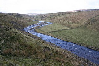
The River Swale in Yorkshire, England, is a major tributary of the River Ure, which becomes the River Ouse, that empties into the North Sea via the Humber Estuary. The river gives its name to Swaledale, the valley through which it flows.

The Brathay is a river of north-west England. Its name comes from Old Norse and means broad river. It rises at a point 1289 feet above sea level near the Three Shire Stone at the highest point of Wrynose Pass in the Lake District. Its catchment area includes the northern flanks of Wetherlam, Great Carrs and others of the Furness Fells, as well as a substantial area of the Langdale Fells.

Touro is a municipality of northwestern Spain in the province of A Coruña, in the autonomous community of Galicia. It has a population of 4,082 inhabitants. Touro has an area of 15.34 km2.
The River Wenning is a tributary of the River Lune, flowing through North Yorkshire and Lancashire. The name derives from the Old English Wann, meaning dark river.
St. John's Beck is a river in the Lake District of Cumbria, England.

The River Eea is a small river in the Lake District, Cumbria, England running through the Furness region, which until 1974 was part of Lancashire. It is a relatively short system that arises from numerous small becks and streams throughout the Cartmel Valley. Its course is approximately 10 km long and its mouth is on Sand Gate marshes near Flookburgh, between Barrow and Kendal. It principally flows in a south-westerly direction.

The River Wampool is a river flowing through north western Cumbria in England. It is in the Waver and Wampool catchment which includes the towns of Silloth and Wigton.

The River Marron is a river of Cumbria, England.

The River Hindburn is a river in Lancashire, England. The Hindburn rises at Thrushgill where three smaller streams combine. The river proceeds northwards past Lowgill to Wray where it merges with the River Roeburn before carrying on to meet the River Wenning in Hornby Park.
Leck Beck is a watercourse in Lancashire with its source on Crag Hill in Cumbria between Leck Fell and Casterton Fell.
Artle Beck is a minor river of Lancashire, England.

The River Grizedale, also known as Grizedale Beck, is a river in Lancashire, England.
The River Lune is a river in County Durham, England.

Naddle Beck is a minor river of Cumbria, England.

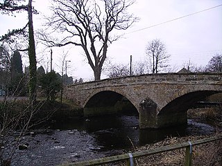
Arkle Beck is the stream running through the valley of Arkengarthdale in the Yorkshire Dales, England. It is a tributary of the River Swale, which it joins just past Reeth at Grinton Bridge. The beck itself has several tributaries which include:

The River Alun is a small river in northwest Pembrokeshire, Wales, which rises near Tretio Common and flows southwestwards to St Davids to empty into St Bride's Bay at the rocky inlet of Porth Clais.

Stonebeck Down is a civil parish in Harrogate district, North Yorkshire, England. The main settlements in the parish are the village of Ramsgill and the hamlets of Stean and Heathfield. The population of the parish in the 2011 census was 192.
