The canal and railway
The Carlisle canal was built to allow sea access for Carlisle to Ireland, Scotland and Liverpool. The sea terminus was at Port Carlisle, and a sea lock and basin was built there in 1819. Four years later the canal was completed to Carlisle, and Port Carlisle became the centre of a good deal of transhipment trade, and passenger traffic via steam packets. However, the canal was short-lived due to competition from deep-water ports and the railways, and it closed in 1853. The canal was filled in and was used to lay the track for the Port Carlisle Railway which opened in 1854. The offshore wharf was connected to the rail system to allow continued access to Carlisle.
The direct passenger service to Carlisle ceased two years later when the railway to Silloth opened and a horse-drawn tram, the "Dandy", was substituted to join the Silloth line at Drumburgh. Freight still travelled on the railway from Port Carlisle, but decreased as the channel silted, and the much better dock facilities at Silloth were used. In 1914 to prevent closure of the line, a steam railmotor called 'Flower of Yarrow' was introduced and this service lasted until the branch was closed in 1932. [1] The village was served by the Port Carlisle railway station.
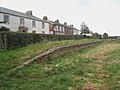
Remains of Railway station in 2010, now a car park.
Samuel Bough (1822–1878) – The Solway at Port Carlisle
Port Carlisle Methodist chapel
Interior of the chapel
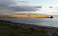
The offshore wharf built 1836 to accommodate larger vessels that could not enter the canal basin.
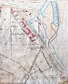
Map of Port Carlisle showing remains of canal basin, and the railway.
The Port Carlisle horse-drawn tram; the "Dandy" in the National Railway Museum.
This page is based on this
Wikipedia article Text is available under the
CC BY-SA 4.0 license; additional terms may apply.
Images, videos and audio are available under their respective licenses.