| Old Hutton | |
|---|---|
| Village | |
 Old Hutton  Old Hutton Location within the United Kingdom | |
| Country | England |
| Sovereign state | United Kingdom |
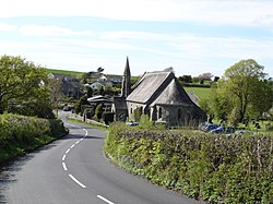
Old Hutton is a village in Westmorland and Furness, Cumbria, England. It is in the civil parish of Old Hutton and Holmescales [1] [2] In the 2001 census the parish had a population of 357, [3] increasing at the 2011 census to 417. [4]
Contents
The parish church, dedicated to St John the Baptist, is in the Kendal Deanery of the Diocese of Carlisle. [5]