Old Hutton and Holmescales

Last updated
Old Hutton and Holmescales
St John The Baptist's Church, Old Hutton - geograph.org.uk - 412358.jpg
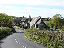
St John the Baptist's Church, Old Hutton
Location map United Kingdom South Lakeland.svg
Red pog.svg
Old Hutton and Holmescales
Location in South Lakeland
Cumbria UK location map.svg
Red pog.svg
Old Hutton and Holmescales
Location within Cumbria
Population417 
Civil parish
  • Old Hutton and Holmescales
District
Shire county
Region
Country England
Sovereign state United Kingdom
Post town KENDAL
Postcode district LA8
Dialling code 01539
Police Cumbria
Fire Cumbria
Ambulance North West
UK Parliament
List of places
UK
England
Cumbria
54°24'0"N, 2°42'36"W 54°24′0″N2°42′36″W / 54.40000°N 2.71000°W / 54.40000; -2.71000

Old Hutton and Holmescales is a civil parish in the South Lakeland district, in the county of Cumbria, England. In the 2001 census the parish had a population of 357, [1] increasing at the 2011 census to 417. [2] The parish is bordered by the civil parishes of New Hutton, Stainton, Preston Richard, Preston Patrick, Killington, and Lupton. [3]

The parish includes the villages and hamlets of Old Hutton, Holmescales and Middleshaw. There are eight listed buildings in Old Hutton and Holmescales, one of grade II* and seven of grade II.

Holmescales was described in 1870-1872 as "a hamlet in Old Hutton-with-Holmescales township". [4]

History

Old Hutton and Holmescales became a civil parish in 1866. [5]

Related Research Articles

<span class="mw-page-title-main">Sedbergh</span> Town in Cumbria, England

Sedbergh is a town and civil parish in Cumbria, England. The 2001 census gave the parish a population of 2,705, increasing at the 2011 census to 2,765. Historically in the West Riding of Yorkshire, it lies about 10 miles (16 km) east of Kendal, 28 miles (45 km) north of Lancaster and about 10 miles (16 km) north of Kirkby Lonsdale, just within the Yorkshire Dales National Park. It stands at the foot of Howgill Fells, on the north bank of the River Rawthey, which joins the River Lune 2 miles (3 km) below the town.

<span class="mw-page-title-main">Beetham</span> Village and civil parish in Cumbria, England

Beetham is a village and civil parish in Cumbria, England, situated on the border with Lancashire, 6 miles (10 km) north of Carnforth. It is part of the Arnside and Silverdale Area of Outstanding Natural Beauty. In the 2001 census the parish had a population of 1,724, increasing at the 2011 census to 1,784.

<span class="mw-page-title-main">Broughton West</span> Human settlement in England

Broughton West is a former civil parish in the South Lakeland district of Cumbria, England. In the 2001 census the parish had a population of 954, decreasing at the 2011 census to 912. The parish includes the town of Broughton in Furness, the small village of Foxfield, and the hamlets of Bank End, Lower Hawthwaite and Broughton Mills.

<span class="mw-page-title-main">Mungrisdale</span> Human settlement in England

Mungrisdale is a small village and civil parish in the north east of the English Lake District in Cumbria. It is also the name of the valley in which the village sits. Mungrisdale is a popular starting point for ascents of the nearby hills, such as Bowscale Fell, Bannerdale Crags and Souther Fell. It lies on the River Glenderamackin, a tributary of the Greta.

<span class="mw-page-title-main">Hutton Roof, South Lakeland</span> Human settlement in England

Hutton Roof is a village and civil parish in the South Lakeland district of Cumbria, England, close to Kirkby Lonsdale and Hutton Roof Crags. Historically in Westmorland, the parish includes the hamlet of Newbiggin. In the 2001 census the parish had a population of 193, increasing at the 2011 census to 218.

<span class="mw-page-title-main">Lupton, Cumbria</span> Human settlement in England

Lupton is a linear village and civil parish in the South Lakeland district of Cumbria, England, along the main A65 road north west of Kirkby Lonsdale, 2.3 miles (3.7 km) from the village of Hutton Roof. In the 2001 census the parish had a population of 165, decreasing slightly at the 2011 census to 162.

<span class="mw-page-title-main">Cartmel Fell</span> Human settlement in England

Cartmel Fell is a hamlet and a civil parish in the South Lakeland district of Cumbria, England. In the 2001 census the parish had a population of 309, increasing at the 2011 census to 329. The village of Cartmel and Cartmel Priory are not in this parish but in Lower Allithwaite, to the south: Cartmel Fell church is about 7 miles north of Cartmel Priory.

<span class="mw-page-title-main">Mansergh, Cumbria</span> Human settlement in England

Mansergh is a village and civil parish in the South Lakeland district of the English county of Cumbria. It includes the village of Mansergh and the hamlet of Old Town, and is located 3.3 miles (5.3 km) north of Kirkby Lonsdale, 9.8 miles (15.8 km) south east of Kendal and 53.2 miles (85.6 km) south of Carlisle. In the 2001 census the parish had a population of 141, decreasing at the 2011 census to 124.

<span class="mw-page-title-main">Staveley-in-Cartmel</span> Human settlement in England

Staveley-in-Cartmel is a small village and civil parish in South Lakeland district, Cumbria, England. It lies east of Newby Bridge, near the south end of Windermere, 9 miles (14 km) northeast of Ulverston. It is sometimes known as Staveley-in-Furness. Both names distinguish it from another Staveley in Cumbria. In the 2001 census the parish had a population of 428, decreasing at the 2011 census to 405.

<span class="mw-page-title-main">Hutton Roof, Eden</span>

Hutton Roof is a hamlet and former civil parish, now in the parish of Mungrisdale, in the Eden district, in the county of Cumbria, England, near Penrith. It is at an elevation of 308 metres (1,010 ft), between the valley of the River Caldew and that of its tributary Gillcambon Beck. In 1931 the parish had a population of 108. The civil parish of Mungrisdale, which is made up of eight hamlets including Hutton Roof, had a population of 297 in the 2011 United Kingdom census.

<span class="mw-page-title-main">Preston Patrick</span> Village and parish in Cumbria, England

Preston Patrick is a village and civil parish in South Lakeland, Cumbria, England. It has junction 36 of the M6 motorway in its south west corner and extends north east on both sides of the motorway until just beyond the B2564 road. In the 2001 census the parish had a population of 438, decreasing at the 2011 census to 426.

<span class="mw-page-title-main">New Hutton</span>

New Hutton is a village and civil parish in South Lakeland, Cumbria, England. At the 2011 Census, it had a population of 348.

<span class="mw-page-title-main">Old Hutton</span>

Old Hutton is a village in South Lakeland, Cumbria, England. It is in the civil parish of Old Hutton and Holmescales In the 2001 census the parish had a population of 357, increasing at the 2011 census to 417.

<span class="mw-page-title-main">Preston Richard</span>

Preston Richard is a civil parish in South Lakeland, Cumbria, England. It includes the village of Endmoor, and the hamlets of Crooklands, Birkrigg Park, Milton, Low Park, and Summerlands.

<span class="mw-page-title-main">Whinfell</span> Human settlement in England

Whinfell is a civil parish in South Lakeland, Cumbria, England. It does not have a parish council but a parish meeting. The parish lies north east of Kendal, between the A6 and the A685. The neighbouring parishes are Grayrigg to the east, Docker to the south, Skelsmergh to the south west, Selside and Fawcett Forest to the west, and Tebay in Eden District to the north.

<span class="mw-page-title-main">Skelwith</span> Civil parish in South Lakeland, Cumbria, England

Skelwith is a civil parish in South Lakeland, Cumbria, England, which includes the village of Skelwith Bridge. In the 2001 census the parish had a population of 185, decreasing at the 2011 census to 155. It has a parish council. The parish lies west of the northern end of Windermere. Historically, Skelwith is the northernmost settlement in Lancashire.

<span class="mw-page-title-main">Strickland Ketel</span> Human settlement in England

Strickland Ketel is a civil parish in South Lakeland, Cumbria, England. In the 2001 census the parish had a population of 1,093, increasing at the 2011 census to 1,105. It borders the north west of Kendal, on both sides of the A591 road, and is also bordered by the parishes of Underbarrow and Bradleyfield to the south west, Crook to the west, Nether Staveley to the north west, Strickland Roger to the north east, and Skelsmergh to the east.

Old Hutton and Holmescales is a civil parish in the South Lakeland District of Cumbria, England. It contains eight listed buildings that are recorded in the National Heritage List for England. Of these, one is listed at Grade II*, the middle of the three grades, and the others are at Grade II, the lowest grade. The parish contains the village of Old Hutton and the hamlet of Middleshaw, and is otherwise entirely rural. The listed buildings consist of three houses, a former gateway, three milestones and a boundary stone.

<span class="mw-page-title-main">Skelsmergh and Scalthwaiterigg</span> Civil parish in Cumbria, England

Skelsmergh and Scalthwaiterigg is a civil parish in South Lakeland district, Cumbria, England. It was formed on 1 April 2015 by merging the parishes of Skelsmergh and Scalthwaiterigg, which had shared a parish council since 2007.

<span class="mw-page-title-main">Dockray, Eden</span> Hamlet in England

Dockray is a village in the civil parish of Matterdale, in the Eden district, in the county of Cumbria, England. In the 2011 census, the parish had 483 residents, roughlt an 8% decrease from 526 residents in 2001. Dockray is located approximately eight miles south west of Penrith, and is accessible off of the A5091 road.

References

  1. UK Census (2001). "Local Area Report – Old Hutton and Holmescales Parish (16UG055)". Nomis. Office for National Statistics . Retrieved 9 May 2021.
  2. "Custom report - Nomis - Official Census and Labour Market Statistics". www.nomisweb.co.uk. Retrieved 2022-10-18.
  3. Councils, Cumbria Association of Local. "South Lakeland". www.calc.org.uk. Retrieved 2022-10-18.
  4. Wilson, John Marius (1870–1872). Imperial Gazetteer of England and Wales. Vol. III. p. 971. Retrieved 3 March 2016.
  5. "Relationships and changes Old Hutton and Holmescales Ch/Tn/CP through time". A Vision of Britain through Time. Retrieved 18 October 2022.