Colton, Cumbria

Last updated

Colton
Colton Church.JPG
Colton Church
Cumbria UK location map.svg
Red pog.svg
Colton
Location within Cumbria
Population672 (2011) [1]
OS grid reference SD3186
Civil parish
  • Colton
District
Shire county
Region
Country England
Sovereign state United Kingdom
Post town ULVERSTON
Postcode district LA12
Dialling code 01229
Police Cumbria
Fire Cumbria
Ambulance North West
UK Parliament
List of places
UK
England
Cumbria
54°15′58″N3°03′07″W / 54.266°N 3.052°W / 54.266; -3.052 Coordinates: 54°15′58″N3°03′07″W / 54.266°N 3.052°W / 54.266; -3.052

Colton is a village and civil parish in the South Lakeland district of Cumbria, England. In the 2001 census the parish had a population of 765, [2] decreasing at the 2011 census to 672. [1] It was historically part of Lancashire. Its name has been recorded as Coleton (which is Old English for 'village')[ citation needed ] and Coulton, and its existence has been recorded as early as 1202. [3]

Contents

The village is in the historical district of Furness and within the boundaries of the Lake District National Park. It is about 2 km north of the A590 between Newby Bridge and Ulverston.

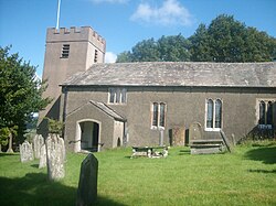
The settlement is situated on an incline, at the top of which is Colton Church, which was built in 1575 and rebuilt 25 years later. [3] Colton Beck, which runs beside the village, was once known as Cole, meaning 'hazel stream'. Three miles from the village there is an historic Quaker meeting house at Colthouse. [3] The parish includes Finsthwaite, Lakeside, Oxen Park, Nibthwaite, Bouth, and Rusland within its boundaries. [4]

See also

Related Research Articles

Windermere, Cumbria (town) Human settlement in England

Windermere is a town and civil parish in the South Lakeland District of Cumbria, England. In the 2001 census the parish had a population of 8,245, increasing at the 2011 census to 8,359. It lies about half a mile (1 km) east of the lake, Windermere. Although the town Windermere does not touch the lake, it has now grown together with the older lakeside town of Bowness-on-Windermere, though the two retain distinguishable town centres. Tourism is popular in the town owing to its proximity to the lake and local scenery. Boats from the piers in Bowness sail around the lake, many calling at Ambleside or at Lakeside where there is a restored railway. Windermere Hotel opened at the same time as the railway.

Burton-in-Kendal Human settlement in England

Burton-in-Kendal is a village and civil parish on the extreme southern edge of Cumbria, England. The parish contains around 660 houses and in the 2001 census had a population of 1,411, increasing at the 2011 census to 1,497. Historically within the county of Westmorland, the village straddles the A6070 road between Crooklands and Carnforth, at a point around midway between Lancaster and Kendal, and is in the shadow of the nearby limestone outcrop known as Farleton Knott.

Eskdale, Cumbria Human settlement in England

Eskdale is a glacial valley and civil parish in the western Lake District National Park in Cumbria, England. It forms part of the Borough of Copeland, and in 2001 had a population of 264, increasing to 304 at the 2011 Census. One of the Lake District's most popular tourist attractions, the Ravenglass and Eskdale Railway, runs through the valley, though along with other western valleys of the Lake District, Eskdale is notably quieter during the high summer season than the more accessible eastern areas.

Haverthwaite Human settlement in England

Haverthwaite is a small village and civil parish in the Furness region of Cumbria, England. It is also within the boundaries of the Lake District National Park. It is located several miles east of Ulverston and is near the southern end of Windermere. In the 2001 census the parish had a population of 728, increasing at the 2011 census to 797.

Orton, Eden Village in Cumbria, England

Orton is a village and civil parish in Cumbria, England. It lies 15 miles (24 km) south of Penrith, 8 miles (13 km) from Appleby-in-Westmorland and 1.5 miles (2.4 km) from the M6 motorway. It is in the upper Lune Valley, set at the foot of Orton Scar in the Orton Fells. The Lake District is nearby. A few miles from Orton Scar is the Eden valley. The parish, historically in the county of Westmorland, now belongs to the Eden district of Cumbria. The parish had a population of 594 in 2001, decreasing to 588 at the 2011 Census.

Patterdale Human settlement in England

Patterdale is a small village and civil parish in the eastern part of the English Lake District in the Eden District of Cumbria, in the traditional county of Westmorland, and the long valley in which they are found, also called the Ullswater Valley. The parish had a population of 460 in 2001, increasing to 501 at the 2011 Census.

Lakes, Cumbria Human settlement in England

Lakes is a large civil parish in the South Lakeland district of Cumbria, England. In the 2001 census the parish had a population of 5,127, decreasing at the 2011 census to 4,420. It covers the small town of Ambleside, and the villages and hamlets of Clappersgate, Rydal, Grasmere, Troutbeck, Chapel Stile, Elterwater, Little Langdale and Waterhead.

Barton, Cumbria Hamlet in the civil parish of Barton and Pooley Bridge, in the Eden district of Cumbria, England

Barton is a hamlet in the civil parish of Barton and Pooley Bridge, in the Eden district of Cumbria, England. The parish is on the edge of the Lake District National Park, and had a population of 232 according to the 2001 census, increasing slightly to 238 at the 2011 Census. The parish includes the small hamlet of Barton, the village of Pooley Bridge and part of Ullswater. The parish was renamed from "Barton" to "Barton and Pooley Bridge" on the 1st of April 2019.

Sockbridge and Tirril Human settlement in England

Sockbridge and Tirril is a small civil parish in Eden District, Cumbria. It had a population of 397 in 2001, increasing to 415 at the 2011 Census. It comprises the adjoining settlements of Tirril, Sockbridge and Thorpe. All three were once separate places but are now, in effect, a single village. They are near Penrith. The two villages are separated by a river.

Lowther, Cumbria Human settlement in England

Lowther is a civil parish in Eden District, Cumbria. Within the parish are the settlements of Lowther Village, Newtown or Lowther Newtown, Hackthorpe, Whale, and Melkinthorpe. At the 2001 census the parish had a population of 402, increasing to 465 at the 2011 Census.

Shap Rural Human settlement in England

Shap Rural is a very large, but sparsely populated, civil parish in the Eden District of Cumbria in England, covering part of the Lake District National Park. It had a population of 119 in 2001, increasing to 130 at the 2011 Census.

Ulpha Human settlement in England

Ulpha is a small village and civil parish in the Duddon Valley in the Lake District National Park in Cumbria, England. Historically in Cumberland, it forms part of the borough of Copeland. At Ulpha a road leaves the Duddon Valley to cross Birker Fell to the valley of Eskdale. In the 2001 census the parish had a population of 159, reducing at the 2011 Census to 128.

Threlkeld Human settlement in England

Threlkeld is a village and civil parish in the north of the Lake District in Cumbria, England, to the east of Keswick. It lies at the southern foot of Blencathra, one of the more prominent fells in the northern Lake District, and to the north of the River Glenderamackin. The parish had a population of 454 in the 2001 census, decreasing to 423 at the Census 2011.

Beckermet Village and civil parish in the English county of Cumbria, located near the coast between Egremont and Seascale

Beckermet is a village and civil parish in Cumbria, England, between Egremont and Seascale. The parish had a population of 1,619 in the 2011 census.

Mungrisdale Human settlement in England

Mungrisdale is a small village and civil parish in the north east of the English Lake District in Cumbria. It is also the name of the valley in which the village sits. Mungrisdale is a popular starting point for ascents of the nearby hills, such as Bowscale Fell, Bannerdale Crags and Souther Fell. It lies on the River Glenderamackin, a tributary of the Greta.

Lamplugh Human settlement in England

Lamplugh is a scattered community and civil parish located in West Cumbria on the edge of the English Lake District and historically part of Cumberland. It had a population of 763 in 2001, increasing to 805 at the 2011 Census.

Underbarrow Human settlement in England

Underbarrow is a small village in Cumbria, England, located 3 miles (4.8 km) west of Kendal. The village is in the Lake District National Park. It is in the civil parish of Underbarrow and Bradleyfield, in South Lakeland district, and has a parish council. In the 2001 census Underbarrow and Bradleyfield had a population of 351, decreasing at the 2011 census to 330.

Ousby Human settlement in England

Ousby is a village and civil parish in Eden district, in the English county of Cumbria. It is a Thankful Village, one of 52 parishes in England and Wales that suffered no casualties during World War I. The parish had a population of 362 in 2001, which had increased to 447 at the 2011 Census, and includes the hamlets of Crewgarth, Row, Shire and Townhead. Melmerby parish was absorbed on 1 April 1934, on 1 April 2019 Melmerby became a separate parish again.

Staveley-in-Cartmel Human settlement in England

Staveley-in-Cartmel is a small village and civil parish in South Lakeland district, Cumbria, England. It lies east of Newby Bridge, near the south end of Windermere, 9 miles (14 km) northeast of Ulverston. It is sometimes known as Staveley-in-Furness. Both names distinguish it from another Staveley in Cumbria. In the 2001 census the parish had a population of 428, decreasing at the 2011 census to 405.

Irton with Santon Human settlement in England

Irton with Santon is a civil parish in Copeland, Cumbria, England, which includes the village of Santon Bridge. It has a parish council. It had a population of 373 in 2001, decreasing to 316 at the 2011 Census.

References

  1. 1 2 UK Census (2011). "Local Area Report – Colton Parish (E04002596)". Nomis. Office for National Statistics . Retrieved 28 April 2021.
  2. UK Census (2001). "Local Area Report – Colton Parish (16UG013)". Nomis. Office for National Statistics . Retrieved 28 April 2021.
  3. 1 2 3 "Colton, Cumbria, The Lake District". The Cumbria Directory. Retrieved 13 August 2009.
  4. "Colton Parish Council". Colton Parish Council. Retrieved 13 August 2009.

Commons-logo.svg Media related to Colton, Cumbria at Wikimedia Commons