
Eden was a local government district in Cumbria, England, based at Penrith Town Hall in Penrith. It was named after the River Eden, which flowed north through the district toward Carlisle. Its population of 49,777 at the 2001 census, increased to 52,564 at the 2011 Census. A 2019 estimate was 53,253. In July 2021 it was announced that, in April 2023, Cumbria would be divided into two unitary authorities. On 1 April 2023, Eden District Council was abolished and its functions transferred to the new authority Westmorland and Furness, which also covers the former districts of Barrow-in-Furness and South Lakeland.

Kirkby Stephen is a market town and civil parish in Cumbria, England. It lies on the A685 and is surrounded by sparsely populated hill country, about 25 miles (40 km) from the nearest larger towns, Kendal and Penrith. The River Eden rises 6 miles (10 km) away in the peat bogs below Hugh Seat and passes the eastern edge of the town. At the 2001 census the parish had a population of 1,832. In 2011, it had a population of 1,522.
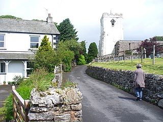
Orton is a village and civil parish in the Westmorland and Furness district, in the ceremonial county of Cumbria, England. It lies 15 miles (24 km) south of Penrith, 8 miles (13 km) from Appleby-in-Westmorland and 1.5 miles (2.4 km) from the M6 motorway. The village is in the upper Lune Valley, at the foot of Orton Scar in the Orton Fells. The Lake District is nearby. The parish includes a wide area outside the village, and had a population of 594 in 2001, decreasing to 588 at the 2011 Census. Until 1974 it was in Westmorland, from 1974 to 2023 it was in Eden district.
Sedbergh is a town and civil parish in the ceremonial county of Cumbria. It falls within the historic boundaries of the West Riding of Yorkshire. Since April 2023, it has been administered by Westmorland and Furness local authority. The 2001 census gave the parish a population of 2,705, increasing at the 2011 census to 2,765. It lies about 10 miles (16 km) east of Kendal, 28 miles (45 km) north of Lancaster and about 10 miles (16 km) north of Kirkby Lonsdale, within the Yorkshire Dales National Park. It stands at the foot of Howgill Fells, on the north bank of the River Rawthey, which joins the River Lune 2 miles (3 km) below the town.

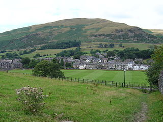
Shap is a village and civil parish located among fells and isolated dales in Westmorland and Furness, Cumbria, England. The village is in the historic county of Westmorland. The parish had a population of 1,221 in 2001, increasing slightly to 1,264 at the 2011 Census.

Patterdale is a small village and civil parish in the Westmorland and Furness district of Cumbria, England. It is in the eastern part of the Lake District, and the name is also used for the long valley in which the village sits, also called the Ullswater Valley. The parish had a population of 460 in 2001, increasing to 501 at the 2011 census.

Coniston is a village and civil parish in the Westmorland and Furness district of Cumbria, England. In the 2001 census the parish had a population of 1,058, decreasing at the 2011 census to 928. Within the boundaries of the historic county of Lancashire, it is in the southern part of the Lake District National Park, between Coniston Water, the third longest lake in the Lake District, and Coniston Old Man.
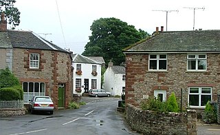
Bolton is a village and civil parish in Westmorland and Furness, Cumbria, England, about 4 miles (6 km) north west of Appleby-in-Westmorland, and on the River Eden. According to the census of 2001, it had a population of 416, increasing to 435 at the census of 2011. The parish touches Brougham, Colby, Cliburn, Crackenthorpe, King's Meaburn, Kirkby Thore, Morland and Temple Sowerby.
The Barony of Westmorland also known as North Westmorland, the Barony of Appleby, Appleshire or the Bottom of Westmorland, was one of two baronies making up the English historical county of Westmorland, the other being the Barony of Kendal. Both of them evolved from medieval feudal baronies. Geographically, the barony covered the northern part of the larger county of the same name, and was divided into two wards – East Ward and West Ward. It covered an area similar to that of the former Eden District of the new county of Cumbria, although it did not include Penrith, which was the administrative capital of the district.
Kirkoswald is a village, civil parish, and former market town located in Westmorland and Furness, England, about 9 miles (14 km) from Penrith. The village is in the historic county of Cumberland. The village, referred to colloquially as KO, had a population of 870 at the 2001 census, which rose to 901 at the 2011 Census.

Hesket is a large civil parish in the Westmorland and Furness unitary district of Cumbria, England, on the main A6 between Carlisle and Penrith. At the 2001 census it had a population of 2,363, increasing to 2,588 at the 2011 census, and estimated at 2,774 in 2019. The parish was formed in 1894 with the passing of the Local Government Act 1894 and was enlarged to incorporate the parish of Plumpton Wall following a County Review Order in 1934. Hesket is part of the historic royal hunting ground of Inglewood Forest. Settlement in the parish dates back to the Roman occupation.

Great Salkeld is a small village and civil parish in Westmorland and Furness, Cumbria, England, a few miles to the north east of Penrith and bordering the River Eden. At the 2001 census the parish had a population of 445, decreasing to 412 at the 2011 Census.

Temple Sowerby is a village and civil parish in Cumbria, northern England. It is close to the main east–west A66 road about 8 miles (13 km) east of Penrith in the Eden Valley. At the 2011 census Temple Sowerby was grouped with Newbiggin giving a total population of 528.

Holme is a village and civil parish in the Westmorland and Furness district of Cumbria, England, about 2 miles (3.2 km) north of Burton-in-Kendal and 3 miles (4.8 km) south east of Milnthorpe. The parish had a population of 1,167 at the 2001 census, increasing to 1,486 at the 2011 Census.
Warcop is a village and civil parish in Westmorland and Furness, Cumbria, England, which had a population of 532 at the 2011 census.

King's Meaburn is a small village and civil parish in Cumbria, England. It is located 5 miles (8.0 km) from Appleby-in-Westmorland and 10 miles (16 km) from Penrith, situated in the valley of the River Lyvennet. The river flows just to the west of the village and was crossed by a ford on the road to Newby and Morland. According to the 2001 census, the parish had a population of 105, which increased to 135 according to the 2011 Census.

Cliburn is a village and civil parish in the Westmorland and Furness Unitary Authority of Cumbria, England. The civil parish includes the hamlet of Town Head. In 2001 the population was 204, increasing to 274 at the 2011 Census.

Newby is a village and civil parish in the Westmorland and Furness district of the county of Cumbria, England. It is about 7 miles (11 km) from the large town of Penrith and about 5 miles (8 km) from the small town of Appleby-in-Westmorland, and has a population of 164. Nearby is Newby Beck. Newby has a post office. The population at the 2011 Census was less than 100 and data was included with Sleagill.

Sleagill is a small village and civil parish in the Westmorland and Furness district of Cumbria, England. At the 2011 census Sleagill was grouped with Newby giving a total population of 282.

Staveley-in-Cartmel is a village and civil parish in Westmorland and Furness Unitary Authority, Cumbria, England. It lies east of Newby Bridge, near the south end of Windermere, 9 miles (14 km) northeast of Ulverston. It is sometimes known as Staveley-in-Furness. Both names distinguish it from another Staveley in Cumbria. In the 2001 census the parish had a population of 428, decreasing at the 2011 census to 405.


