Great Orton

Last updated

Great Orton
St Giles Great Orton Geograph-1794223-by-John-Lord.jpg
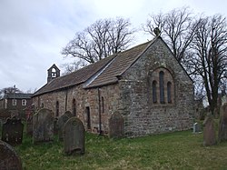
St. Giles' Church, Great Orton
Location map United Kingdom City of Carlisle.svg
Red pog.svg
Great Orton
Location in the City of Carlisle district, Cumbria
Cumbria UK location map.svg
Red pog.svg
Great Orton
Location within Cumbria
Population453 (2011)
OS grid reference NY328542
Civil parish
Unitary authority
Shire county
Region
Country England
Sovereign state United Kingdom
Post town CARLISLE
Postcode district CA5
Dialling code 01228
Police Cumbria
Fire Cumbria
Ambulance North West
UK Parliament
List of places
UK
England
Cumbria
54°52′41″N3°02′49″W / 54.878°N 3.047°W / 54.878; -3.047

Great Orton is a village in the civil parish of Orton, in the Cumberland district of the ceremonial county of Cumbria, England. The population of the civil parish taken at the 2011 census was 453. [1] Historically, the village is part of Cumberland. From 1974 to 2023 it was in Carlisle district.

Contents

Location

Great Orton is close to England's border with Scotland. The English city of Carlisle lies about five miles to the east, whereas the Scottish town of Gretna lies just eight miles to the north..

Amenities

Great Orton has a primary school with nursery, a pub (the Wellington), a church (St Giles), a village hall and a butcher's shop (R J Mulholland). The village hall is available to hire and you can find more information at https://web.archive.org/web/20140328160249/http://www.greatortonvillagehall.co.uk/

Nearby settlements

Nearby settlements include the city of Carlisle, the villages of Thursby, Little Orton, Kirkbampton, Thurstonfield, Moorhouse, Wiggonby and the hamlet of Orton Rigg.

Transport

For transport there is the B5307 road, the A595 road and the A596 road. There is also Carlisle railway station about six miles away.

See also

Related Research Articles

<span class="mw-page-title-main">Appleby-in-Westmorland</span> Market town in Cumbria, England

Appleby-in-Westmorland is a market town and civil parish in Westmorland and Furness, Cumbria, England, with a population of 3,048 at the 2011 Census. Crossed by the River Eden, Appleby is the county town of the historic county of Westmorland. It was known just as Appleby until 1974–1976, when the council of the successor parish to the borough changed it to retain the name Westmorland, which was abolished as an administrative area under the Local Government Act 1972, before being revived as Westmorland and Furness in 2023. It lies 14 miles (23 km) south-east of Penrith, 32 miles (51 km) south-east of Carlisle, 27 miles (43 km) north-east of Kendal and 45 miles (72 km) west of Darlington.

<span class="mw-page-title-main">Alston, Cumbria</span> Town in England

Alston is a town in Westmorland and Furness, Cumbria, England, within the civil parish of Alston Moor on the River South Tyne. It shares the title of the 'highest market town in England', at about 1,000 feet (300 m) above sea level, with Buxton, Derbyshire. Despite its altitude, the town is easily accessible via the many roads which link the town to Weardale, Teesdale, and towns in Cumbria such as Penrith via Hartside Pass, as well as Tynedale. Historically part of Cumberland, Alston lies within the North Pennines, a designated Area of Outstanding Natural Beauty. Much of the town centre is a designated Conservation Area which includes several listed buildings.

<span class="mw-page-title-main">City of Carlisle</span> Former district in Cumbria, England

The City of Carlisle was a local government district of Cumbria, England, with the status of a city. It was named after its largest settlement, Carlisle, but covered a far larger area which included the towns of Brampton and Longtown, as well as outlying villages including Dalston, Scotby and Wetheral. In 2011 the district had a population of 107,524, and an area of 1,039.97 square kilometres (402 sq mi).

<span class="mw-page-title-main">Brampton, Carlisle</span> Town and parish in England

Brampton is a market town and civil parish in the Cumberland unitary authority of Cumbria, England. It is 9 miles (14 km) east of Carlisle and 2 miles (3.2 km) south of Hadrian's Wall. Historically part of Cumberland, it is situated off the A69 road which bypasses it.

<span class="mw-page-title-main">Tebay</span> Human settlement in England

Tebay is a village and civil parish in Cumbria, England, within the historic borders of Westmorland. It lies in the upper Lune Valley, at the head of the Lune Gorge. The parish had a population of 728 in the 2001 census, increasing to 776 at the Census 2011.

<span class="mw-page-title-main">Clifton, Cumbria</span> Village and parish in England

Clifton is a small linear village and civil parish in Cumbria, England. Historically part of Westmorland, it lies 3 miles (4.8 km) south east of Penrith.

<span class="mw-page-title-main">Beaumont, Cumbria</span> Village and civil parish in the City of Carlisle district of Cumbria, England

Beaumont is a village and civil parish in the City of Carlisle district of Cumbria, England. The village lies four miles north-west of Carlisle on the banks of the River Eden.

<span class="mw-page-title-main">Hesket, Cumbria</span> Parish in Cumbria, England

Hesket is a large civil parish in the Eden District of Cumbria, England, on the main A6 between Carlisle and Penrith. At the 2001 census it had a population of 2,363, increasing to 2,588 at the 2011 census, and estimated at 2,774 in 2019. The parish was formed in 1894 with the passing of the Local Government Act 1894 and was enlarged to incorporate the parish of Plumpton Wall following a County Review Order in 1934. Hesket is part of the historic royal hunting ground of Inglewood Forest. Settlement in the parish dates back to the Roman occupation.

<span class="mw-page-title-main">Plumpton, Cumbria</span> Human settlement in England

Plumpton or Plumpton Wall is a small village and former civil parish, in the parish of Hesket, in the Westmorland and Furness district, in the traditional and historic county of Cumberland but now in the ceremonial county of Cumbria, England. It is about 4 miles (6 km) north of Penrith. In 1931 the parish had a population of 320.

<span class="mw-page-title-main">Crosby-on-Eden</span> Human settlement in England

Crosby-on-Eden is the combined name for two small villages, High Crosby and Low Crosby, within the civil parish of Stanwix Rural near Carlisle, in the Cumberland district, in the ceremonial county of Cumbria, England. It was formerly a parish in its own right under the name Crosby upon Eden. In 1931 the parish had a population of 238. On 1 April 1934 the parish was abolished and merged with Stanwix Rural, part also went to Wetheral.

<span class="mw-page-title-main">Waverton, Cumbria</span> Human settlement in England

Waverton is a linear village and civil parish in the Allerdale borough of Cumbria, England. Waverton lies on the main A596 road east of a bridge over the River Waver, 2.2 miles south west from Wigton and 14.2 miles from the nearest city, Carlisle. The river is the reason for Waverton's name as well as it coming from the old English word tuǹ, this meaning "An enclosure; a farmstead; a village; an estate".

<span class="mw-page-title-main">Keisley</span> Human settlement in England

Keisley is a small hamlet in the English county of Cumbria. It is located in the Dufton civil parish and the Eden district.

<span class="mw-page-title-main">Linstock, Cumbria</span> Human settlement in England

Linstock is a village in the civil parish of Stanwix Rural, in the Carlisle District, in the county of Cumbria, England. It is a few miles away from the city of Carlisle and near the River Eden. Circa 1870, it had a population of 205 as recorded in the Imperial Gazetteer of England and Wales.

<span class="mw-page-title-main">Culgaith</span> Village and parish in England

Culgaith is a village and civil parish in the Westmorland and Furness district of Cumbria, north west England. The village is on a ridge above the River Eden, between Temple Sowerby and Langwathby. At the 2001 census the parish had a population of 721, increasing to 826 at the 2011 Census.

<span class="mw-page-title-main">Holme St Cuthbert</span> A civil parish in Cumbria, England

Holme St Cuthbert is a small village and civil parish in the county of Cumbria, United Kingdom. The village is located approximately 23 miles to the south-west of Carlisle, Cumbria's county town, and was historically in the county of Cumberland.

<span class="mw-page-title-main">Smardale</span> Human settlement in England

Smardale is a small village and former civil parish, now in the parish of Waitby, in the Eden district, in Cumbria, England. In 1891 the parish had a population of 36.

<span class="mw-page-title-main">Wiggonby</span> Human settlement in England

Wiggonby is a hamlet in parish of Aikton and the district of Allerdale, in the English county of Cumbria. Historically in Cumberland, it seven miles away from the city of Carlisle and 2 14 miles from the village of Great Orton. The village has an area of 2,404 acres. It has a primary school called Wiggonby CE School, which currently has 48 pupils.

Nicholforest is a civil parish in Cumbria, England bordering Scotland. The population of the civil parish taken at the 2011 census was 372. The parish covers an area that extends about 10 miles east to west and 2 miles north to south. The area was once an extensive forest between England and Scotland, and was a centre for commercial forestry by the Forestry Commission. Today there are still many trees, watered by the River Liddle In 1870–72 John Marius Wilson's Imperial Gazetteer of England and Wales described the landscape as:

References

  1. "Parish population 2011" . Retrieved 23 June 2015.