Workington is a coastal town and civil parish at the mouth of the River Derwent on the west coast in Cumbria, England. At the 2011 census it had a population of 25,207.
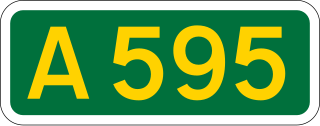
The A595 is a primary route in Cumbria, in Northern England that starts in Carlisle, passes through Whitehaven and goes close to Workington, Cockermouth and Wigton. It passes Sellafield and Ravenglass before ending at the Dalton-in-Furness by-pass, in southern Cumbria, where it joins the A590 trunk road. The road is mostly single carriageway, apart from in central Carlisle, where it passes the castle as a busy dual carriageway road named Castle Way, and prior to that as Bridge Street and Church Street, where it passes close to the McVitie's or Carr's biscuit factory. The Lillyhall bypass is also dual carriageway.

Ravenglass is a coastal village in that lies between Barrow-in-Furness and Whitehaven, on the estuary of three rivers: the Esk, Mite and Irt. It is the only coastal village in the Lake District National Park. Formerly in the historical county of Cumberland, it is now part of the civil parish of Muncaster, the unitary authority of Cumberland, and the ceremonial county of Cumbria.

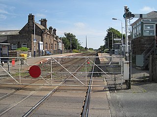
Seascale is a railway station on the Cumbrian Coast Line, which runs between Carlisle and Barrow-in-Furness. The station, situated 33+1⁄4 miles (54 km) north-west of Barrow-in-Furness, serves the village of Seascale in Cumbria. It is owned by Network Rail and managed by Northern Trains.
Bootle is a railway station on the Cumbrian Coast line, which runs between Carlisle and Barrow-in-Furness. The station, situated 24 miles (39 km) north-west of Barrow-in-Furness, serves the village of Bootle in Cumbria. It is owned by Network Rail and managed by Northern Trains.
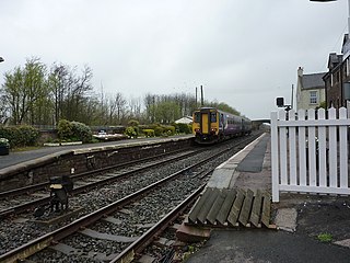
Drigg is a railway station on the Cumbrian Coast Line, which runs between Carlisle and Barrow-in-Furness. The station, situated 31 miles (50 km) north-west of Barrow-in-Furness, serves the villages of Drigg and Holmrook in Cumbria. It is owned by Network Rail and managed by Northern Trains.

Gosforth is a village, civil parish and electoral ward in the Lake District, in Cumberland, England. It is situated on the A595 road between Whitehaven and Barrow-in-Furness. It had a population of 1,230 at the 2001 Census. At the 2011 census Gosforth was grouped with Ponsonby and Wasdale giving a total population of 1,396.

Seascale is a village and civil parish on the Irish Sea coast of Cumbria, England, historically within Cumberland. The parish had a population of 1,754 in 2011, barely decreasing by 0.4% in 2021.

The River Irt is a river in the county of Cumbria in northern England. It flows for approximately 14 miles (22 km) from its source in Wast Water to its estuary at Ravenglass.

Beckermet is a village and civil parish in Cumbria, England, between Egremont and Seascale. The parish had a population of 1,619 in the 2011 census.

Ireby is a village in the Cumberland district of Cumbria, England with a population of around 180. It is located above the River Ellen, just outside the Lake District National Park, in the area locally called Back o'Skiddaw, with views to the Caldbeck Fells. The nearest towns are Wigton, 7 miles (11 km) away, and Cockermouth and Keswick, both 12 miles (19 km) away.

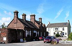
Harrington is a village and former civil parish, now in the parish of Workington, in the Cumberland district, in the ceremonial county of Cumbria, England. It is on the Cumbrian coast south of Workington and north of Whitehaven. Historically part of Cumberland, its industrial history, which largely ended in the late 1930s, included a shipbuilders, iron works, coal mining and steel making. It once had five railway stations. It still has one railway station, on the Cumbrian Coast Line, near the harbour.

The Low Level Waste Repository is the UK's central long-term store for low-level radioactive waste located on the West Cumbrian coast near Drigg village and opened in 1959. It is a subsidiary of the Nuclear Decommissioning Authority.

Beckermet railway station is a disused rail station located in the village of Beckermet in Cumbria.
Woodend railway station was planned by the Whitehaven, Cleator and Egremont Railway on its Sellafield to Moor Row branch, but by the time the station opened the company had been bought out by the LNWR and Furness Railway who operated the line jointly until grouping in 1923.

The Cumbria shootings were a shooting spree that occurred on 2 June 2010 when a lone gunman, taxi driver Derrick Bird, killed twelve people and injured eleven others in Cumbria, England, United Kingdom. Along with the 1987 Hungerford massacre and the 1996 Dunblane school massacre, it is one of the worst criminal acts involving firearms in British history. The shootings ended when Bird killed himself in a wooded area after abandoning his car in the village of Boot.

West Cumberland Hospital is a hospital in Hensingham, a suburb of Whitehaven in Cumbria, England, and was the first district general hospital to be built in England following the creation of the National Health Service. It is managed by the North Cumbria Integrated Care NHS Foundation Trust. A campaign group is fighting to maintain hospital services at the West Cumberland Hospital, many of which have been moved to the Cumberland Infirmary, 40 mi (64 km) away from the population centres of the West Cumbrian coast.
Egremont railway station was built by the Whitehaven, Cleator and Egremont Railway as the first southern terminus of what would become the Moor Row to Sellafield branch. In 1878 the company was bought out by the LNWR and Furness Railway who operated the line jointly until grouping in 1923.

Whicham is a hamlet and civil parish in Copeland, Cumbria, England. At the 2011 census the parish had a population of 382. The parish includes the villages of Silecroft and Kirksanton and the hamlets of Whicham and Whitbeck. Whicham was recorded in the Domesday Book as Witingham.