
The Ravenglass and Eskdale Railway is a 15 in minimum gauge heritage railway in Cumbria, England. The 7-mile (11.3 km) line runs from Ravenglass to Dalegarth Station near Boot in the valley of Eskdale, in the Lake District. At Ravenglass the line ends at Ravenglass railway station on the Cumbrian Coast Line.

Wast Water or Wastwater is a lake located in Wasdale, a valley in the western part of the Lake District National Park, England. The lake is almost three miles long and more than one-third mile (500 m) wide. It is a glacial lake, formed in a glacially 'over-deepened' valley. It is the deepest lake in England at 258 feet (79 m). The surface of the lake is about 200 feet (60 m) above sea level, while its bottom is over 50 feet (15 m) below sea level. It is owned by the National Trust.

Bowfell is a pyramid-shaped mountain lying at the heart of the English Lake District, in the Southern Fells area. It is the sixth-highest mountain in the Lake District and one of the most popular of the Lake District fells for walkers. It is listed in Alfred Wainwright's 'best half dozen' Lake District fells.

Ravenglass is a coastal village in that lies between Barrow-in-Furness and Whitehaven, on the estuary of three rivers: the Esk, Mite and Irt. It is the only coastal village in the Lake District National Park. Formerly in the historical county of Cumberland, it is now part of the civil parish of Muncaster, the unitary authority of Cumberland, and the ceremonial county of Cumbria.

The River Esk, sometimes called the Cumbrian Esk, is a river in Cumbria, England. It flows for approximately 25 km from its source in the Scafells range of mountains to its estuary at Ravenglass. The valley it flows through is known as Eskdale. It is one of two Rivers Esk in Cumbria, and not to be confused with the Border Esk which flows into Cumbria from Scotland.

Eskdale is a civil parish in the western Lake District National Park in Cumbria, England. It is named after the Eskdale valley which the River Esk flows through on its way from the fells of the Lake District to the Irish Sea at Ravenglass. The civil parish is not coterminous with the valley, as the parish also includes the upper valley of the River Mite (Miterdale), whilst the lower reaches of the River Esk are in the civil parish of Muncaster.

Ravenglass is a railway station on the Cumbrian Coast Line, which runs between Carlisle and Barrow-in-Furness. The station, situated 29+1⁄4 miles (47 km) north-west of Barrow-in-Furness, serves the village of Ravenglass in Cumbria. It is owned by Network Rail and managed by Northern Trains.

Boot is a small village in Eskdale on the western side of the English Lake District. It lies within the civil parish of Eskdale, the unitary authority of Cumberland, and the ceremonial county of Cumbria. The main part of the village lies beside the Whillan Beck, whilst its church, St Catherine's, lies 0.6 miles (0.97 km) to the south on the bank of the River Esk. The Whillan Beck flows into the Esk just downstream of the village.

The River Irt is a river in the county of Cumbria in northern England. It flows for approximately 22 kilometres (14 mi) from its source in Wast Water to its estuary at Ravenglass.

Muncaster Fell is a fell at the far western edge of the Lake District National Park, in Cumbria, England. Muncaster Fell is a long, narrow ridge of land, approximately 1.2 km wide and 6 km long, lying between the River Mite to the north, and River Esk to the south. The fell rises from the coast near Ravenglass village to its highest point at Hooker Crag (231 m). The ridge then continues to the north-east, dropping gently to its furthest prominence at Silver Knott (174 m). The fell then falls away rapidly to the village of Eskdale Green at its north-eastern tip.

Irton Road railway station is a railway station on the 15 in gauge Ravenglass & Eskdale Railway in the Lake District National Park and the English county of Cumbria. The station is situated on the western edge of the village of Eskdale Green. It is some 4 miles (6.4 km) from Ravenglass and 3 miles (4.8 km) from Dalegarth for Boot, and trains take 20 minutes to reach their destinations in either direction from this station.
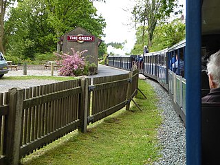
The Green is a railway station on the 15-inch gauge Ravenglass & Eskdale Railway in the Lake District National Park and the English county of Cumbria. The station is situated on the southern edge of the village of Eskdale Green, overlooking the Eskdale valley and Muncaster Fell. It was originally known as King of Prussia after the nearby public house, and later as Eskdale Green. The Eskdale Green name has continued in popular use, and was still in official use in 2017 in the railway's "full" timetable of intermediate stopping places.

Muncaster Mill railway station is a railway station on the 15 in gauge Ravenglass & Eskdale Railway in Cumbria, England. The station is located 1 mile (1.6 km) from Ravenglass and 6 miles (9.7 km) from Dalegarth, at the point where the A595 coast road crosses the line. It is situated on the bank of the River Mite and adjacent to Muncaster Mill, formerly a watermill but now a private house, from which it takes its name.

Fisherground railway station, also known as Fisherground Halt, is on the 15-inch (380 mm) gauge Ravenglass & Eskdale Railway in Cumbria, England. Its main purpose is to serve the adjoining camp site. A passing loop is situated 100 metres (330 ft) to the west of the halt, whilst a no longer used water tank is situated at the halt itself.

Beckfoot railway station is a railway station on the 15" gauge Ravenglass & Eskdale Railway in the English county of Cumbria. It is situated in the civil parish of Eskdale and the Lake District National Park, and is within a 1⁄2 mile (0.80 km) walk of the eastern terminus of the line, at Dalegarth station.

Dalegarth railway station is the easterly terminus of the 15-inch gauge Ravenglass and Eskdale Railway in the English county of Cumbria. It has a café and shop for passengers, along with a run-round loop, turntable and siding for trains.

This article gives details of the locomotives used on the Ravenglass and Eskdale Railway, a 15 in narrow gauge preserved railway line running for 7 miles (11 km) from Ravenglass on the Cumbrian coast to Dalegarth near the village of Boot, in Eskdale.

Boat How or Eskdale Moor is a hill in the English Lake District, near Boot, in the Borough of Copeland, Cumbria. It lies south of Burnmoor Tarn, between the River Mite to the west and the Whillan Beck tributary of Eskdale to the east.

Muncaster is a civil parish in the Cumberland district, in the ceremonial county of Cumbria, England. The parish is 41 miles (66 km) south west of the city of Carlisle. The parish includes the village of Ravenglass. In 2011 the parish had a population of 290. The parish touches Bootle, Drigg and Carleton, Eskdale, Irton with Santon, Ulpha and Waberthwaite.
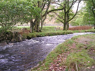
The Whillan Beck is a river in the west of the Lake District National Park in the English county of Cumbria. Administratively, the whole of the course of the Whillan Beck lies in the civil parish of Eskdale and the unitary authority of Cumberland.

