
The Isle of Man is an island in the Irish Sea, between Great Britain and Ireland in Northern Europe, with a population of almost 85,000. It is a British Crown dependency. It has a small islet, the Calf of Man, to its south. It is located at 54°15′N4°30′W.
The Solway Firth is a firth that forms part of the border between England and Scotland, between Cumbria and Dumfries and Galloway. It stretches from St Bees Head, just south of Whitehaven in Cumbria, to the Mull of Galloway, on the western end of Dumfries and Galloway. The Isle of Man is also very near to the firth. The firth comprises part of the Irish Sea.

A site of special scientific interest (SSSI) in Great Britain, or an area of special scientific interest (ASSI) in the Isle of Man and Northern Ireland, is a conservation designation denoting a protected area in the United Kingdom and Isle of Man. SSSI/ASSIs are the basic building block of site-based nature conservation legislation and most other legal nature/geological conservation designations in the United Kingdom are based upon them, including national nature reserves, Ramsar sites, Special Protection Areas, and Special Areas of Conservation. The acronym "SSSI" is often pronounced "triple-S I".

The Moray Firth is a roughly triangular inlet of the North Sea, north and east of Inverness, which is in the Highland council area of north of Scotland.

The Bristol Channel is a major inlet in the island of Great Britain, separating South Wales and South West England. It extends from the smaller Severn Estuary of the River Severn to the North Atlantic Ocean. It takes its name from the English city and port of Bristol.

The Dornoch Firth is a firth on the east coast of Highland, in northern Scotland. It forms part of the boundary between Ross and Cromarty, to the south, and Sutherland, to the north. The firth is designated as a national scenic area, one of 40 such areas in Scotland. The national scenic area covers 15,782 ha in total, of which 4,240 ha is the marine area of the firth below low tide. A review of the national scenic areas by Scottish Natural Heritage in 2010 commented:
By comparison with other east coast firths the Dornoch Firth is narrow and sinuous, yet it exhibits within its compass a surprising variety of landscapes. It is enclosed by abrupt rounded granitic hills clad in heather moor and scree, their Gaelic names of cnoc, meall and creag giving the clue to their character. Their lower slopes are frequently wooded, oakwoods being a noticeable feature of the area, but with other deciduous and coniferous species represented in plantations which vary from the policy plantings of Skibo Castle to the pines of the Struie Forest.
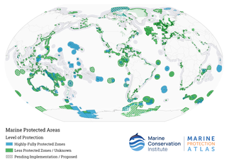
Marine protected areas (MPA) are protected areas of the world's seas, oceans, estuaries or in the US, the Great Lakes. These marine areas can come in many forms ranging from wildlife refuges to research facilities. MPAs restrict human activity for a conservation purpose, typically to protect natural or cultural resources. Such marine resources are protected by local, state, territorial, native, regional, national, or international authorities and differ substantially among and between nations. This variation includes different limitations on development, fishing practices, fishing seasons and catch limits, moorings and bans on removing or disrupting marine life. In some situations, MPAs also provide revenue for countries, potentially equal to the income that they would have if they were to grant companies permissions to fish. The value of MPA to mobile species is unknown.
Marine nature reserve (MNR) is a conservation designation officially awarded by a government to a marine reserve of national significance.

Skomer Marine Conservation Zone is an underwater marine nature reserve located off the coast of Pembrokeshire in Wales. The nature reserve completely surrounds the islands of Skomer and Middleholm, and encompasses the mainland coastline around the end of the Marloes peninsula, including the small bay of Martin's Haven.

The Community of Arran Seabed Trust (COAST) is a registered Scottish charity based on the Isle of Arran, the largest island in the Firth of Clyde. Established in 1995 by two local divers (Howard Wood and Don McNeish) COAST has been a registered charity since 2011 and is run mostly by Arran residents, who all share the same aims to protect the health of the marine environment around the Isle of Arran and within the Firth of Clyde from indiscriminate commercial fishing methods. COAST values the marine biodiversity around the shoreline of Arran and aims to regenerate and protect it for future generations.

Allonby Bay is a crescent-shaped bay of the Solway Firth on the north-western shore of Cumbria, England. The bay is 5.5 miles (8.9 km) across. Its northern point is at Dubmill, between the village of Mawbray and the hamlet of Salta, and its southern end is just to the north of Maryport, near the village of Crosscanonby. The B5300 coast road follows the shoreline of Allonby Bay, running between Silloth in the north and Maryport in the south.

Cumbria Coast is one of England's Marine Conservation Zones. It was designated in 2013 and is one of a number of such zones off the coast of Cumberland and Furness.

Many parts of Scotland are protected in accordance with a number of national and international designations because of their environmental, historical or cultural value. Protected areas can be divided according to the type of resource which each seeks to protect. NatureScot has various roles in the delivery of many environmental designations in Scotland, i.e. those aimed at protecting flora and fauna, scenic qualities and geological features. Historic Environment Scotland is responsible for designations that protect sites of historic and cultural importance. Some international designations, such as World Heritage Sites, can cover both categories of site.

Scarba, Lunga and the Garvellachs is the name of one of the 40 national scenic areas of Scotland. The designated area covers the islands of Scarba, Lunga, and the Garvellachs, all of which lie in the Firth of Lorn, along with much of the surrounding seascape. The national scenic areas are defined so as to identify areas of exceptional scenery and to ensure its protection by restricting certain forms of development, and are considered to represent the type of scenic beauty "popularly associated with Scotland and for which it is renowned". The Scarba, Lunga and the Garvellachs NSA covers 6,542 ha in total, consisting of 2,139 ha of land with a further 4,402 ha being marine.

Blackwater, Crouch, Roach and Colne Estuaries is a Marine Conservation Zone (MCZ), located in Essex, England. It includes the Blackwater, Colne, Crouch and Roach estuaries as well as the coast between them. It extends from the mean high water mark to where the estuary mouths join the North Sea. With a total area of 284 square kilometres (110 sq mi), it the largest inshore MCZ in England.

In Scotland, Marine Protected Areas (MPAs) are areas of sea defined so as to protect to habitats, wildlife, geology, undersea landforms, historic shipwrecks, and to demonstrate sustainable management of the sea. As of December 2020, approximately 37% of Scotland's seas are covered by the Scottish MPA network, which comprises 244 sites in total.

The name Firth of Forth Banks Complex refers to a complex of sand and gravel sea banks in the North Sea, lying at the mouth of the Firth of Forth in the seas off the east coast of Scotland. From south to north the banks are named the Berwick Bank, the Scalp Bank, the Wee Bankie and the Montrose Bank. Since 2014 the banks have been protected as a single Nature Conservation Marine Protected Area, which comprises three discrete zones covering a total area of 213,000 hectares (2,130 km2) of Scottish Offshore Waters.

The marine conservation zones in Yorkshire, were created in 2016 and 2019 after an extensive consultation, which drew criticism of the UK Government's plans which designated only 31 zones out of the projected 127 zones in 2013. An £8 million study recommended the 127 sites, of which, eight lay in and around the coast of Yorkshire.
South-West Deeps (West) MPA, along with the South West Deeps (East) MPA is an offshore Marine Conservation Zone (MCZ), approximately 230 km (140 mi) off Land's End, Cornwall, England, in the Western Channel and Celtic Sea. It was one of twenty-seven MCZs designated on 21 November 2013 by the Marine and Coastal Access Act 2009 and is a predominantly sandy area of the continental shelf, supporting molluscs and crustaceans living in and on the mixed and coarse sediments.
South-West Deeps (East), along with the adjoining the South-West Deeps (West), is an offshore Marine Conservation Zone (MCZ), approximately 190 km off Land's End, Cornwall. It was designated on 31 May 2019 by the Marine and Coastal Access Act 2009 and is a predominantly sandy area of the continental shelf, supporting molluscs and crustaceans living on and in mixed and coarse sediments.

