
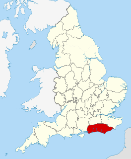
East Sussex is a county in South East England on the English Channel coast. It is bordered by the counties of Kent to the north and east, West Sussex to the west, and Surrey for a short distance to the north-west.
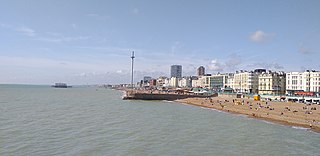
Brighton and Hove is a city and unitary authority in East Sussex, England. It consists primarily of the settlements of Brighton and Hove, alongside neighbouring villages.

Seaford is a town in East Sussex, England, east of Newhaven and west of Eastbourne.

Newhaven is a port town in East Sussex in England, with regular passenger services to Dieppe.
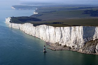
Beachy Head is a chalk headland in East Sussex, England. It is situated close to Eastbourne, immediately east of the Seven Sisters.

The Seven Sisters are a series of chalk sea cliffs on the English Channel coast, and are a stretch of the sea-eroded section of the South Downs range of hills, in the county of East Sussex, in south-east England. The Seven Sisters cliffs run between the mouth of the River Cuckmere near Seaford, and the chalk headland of Beachy Head outside of Eastbourne. Each of the Seven Sisters cliffs are distinguished by dips in-between them, which are the remnants of dry valleys in the chalk South Downs which are being gradually eroded by the sea.

The South Downs Way is a long distance footpath and bridleway running along the South Downs in southern England. It is one of 16 National Trails in England and Wales. The trail runs for 160 km (100 mi) from Winchester in Hampshire to Eastbourne in East Sussex, with about 4,150 m (13,620 ft) of ascent and descent.
The South Downs are a range of chalk hills that extends for about 260 square miles (670 km2) across the south-eastern coastal counties of England from the Itchen valley of Hampshire in the west to Beachy Head, in the Eastbourne Downland Estate, East Sussex, in the east. The Downs are bounded on the northern side by a steep escarpment, from whose crest there are extensive views northwards across the Weald. The South Downs National Park forms a much larger area than the chalk range of the South Downs and includes large parts of the Weald.

The South Downs National Park is England's newest national park, designated on 31 March 2010. The park, covering an area of 1,627 square kilometres (628 sq mi) in southern England, stretches for 140 kilometres (87 mi) from Winchester in the west to Eastbourne in the east through the counties of Hampshire, West Sussex and East Sussex. The national park covers the chalk hills of the South Downs and a substantial part of a separate physiographic region, the western Weald, with its heavily wooded sandstone and clay hills and vales. The South Downs Way spans the entire length of the park and is the only National Trail that lies wholly within a national park.
Cuckmere Valley is a civil parish in the Wealden District of East Sussex, England. As its name suggests, the parish consists of a number of small settlements in the lower reaches of the River Cuckmere.
Cuckmere Haven is an area of flood plains in Sussex, England where the river Cuckmere meets the English Channel between Eastbourne and Seaford. The river is an example of a meandering river, and contains several oxbow lakes. It is a popular tourist destination with an estimated 350,000 visitors per year, where they can engage in long walks, or water activities on the river. The beach at Cuckmere Haven is next to the famous chalk cliffs, the Seven Sisters.

East Dean and Friston is a civil parish in the Wealden District of East Sussex, England.The two villages in the parish are in a dry valley on the South Downs – between Eastbourne three miles (4.8 km) to the east and Seaford an equal distance to the west. The main A259 road goes through both village centres. The coast and much of the land between it and the A259 from the east edge of Seaford to the west edge of Eastbourne is owned by the National Trust, and this has prevented further development to the area.

Hamsey is a civil parish in the Lewes District of East Sussex, England. The parish covers a large area and consists of the villages of Hamsey, Offham and Cooksbridge. The main centres of population in the parish are now Offham and Cooksbridge. Around the main settlements are enlarged fields, isolated old cottages and farms. The winding and undulating parish lanes between banks, old hedge rows, trees, flowery verges and ditches are rightly popular with cyclists and give good views of the Downs.

Pyecombe is a village and civil parish in the Mid Sussex District of West Sussex, England. The name 'Pyecombe' may derive from the Saxon "pic" meaning point or pike, in which case it may mean "valley marked by a projecting hill".
Sussex is a historic county and cultural region in the south of England corresponding roughly in area to the ancient Kingdom of Sussex. It is bounded on the north by Surrey, north-east by Kent, south by the English Channel, and west by Hampshire, and is divided for local government into West Sussex and East Sussex and the city of Brighton and Hove. The city of Brighton & Hove was created a unitary authority in 1997, and was granted City status in 2000. Until then Chichester had been Sussex's only city. By convention, Chichester is Sussex's capital city and Lewes is Sussex's county town.

The Hampshire Basin is a geological basin of Palaeogene age in southern England, underlying parts of Hampshire, the Isle of Wight, Dorset, and Sussex. Like the London Basin to the northeast, it is filled with sands and clays of Paleocene and younger ages and it is surrounded by a broken rim of chalk hills of Cretaceous age.
The Brighton and Lewes Downs Biosphere Reserve is a UNESCO Biosphere Reserve located in Sussex on the southeast coast of England near the city of Brighton and Hove. Forming a central unit of the hills of the South Downs National Park, it is centred on the Brighton chalk block that lies between the River Adur in the west and the River Ouse in the east. Chalk downland makes up the principal terrestrial landscape of the area, bounded at each end by the two river valleys. The coastline is dominated by impressive chalk cliffs in the east and urbanized plains in the west, running to the estuary of the River Adur at Shoreham-by-Sea. The area is nationally and internationally renowned for its arts and culture, distinctive settlements, independent mindset and its links to the surrounding iconic English landscape of downland, white chalk cliffs and beaches.
The Eastbourne Downland Estate is an area of downland at the easternmost end of the South Downs National Park in East Sussex, England. It was bought by the public, following threats to the beauty spots of Beachy Head and the surrounding farmland, which led to a public campaign and Act of Parliament in 1926. It is currently owned and managed, on behalf of the public, by Eastbourne Borough Council.
Kingmere Marine Conservation Zone is in the English Channel, between 3 miles (5 km) and 6 miles (10 km) off the West Sussex coast to the south of Littlehampton and Worthing. It covers an area of around 47 square kilometres (18 sq mi).

Beeding Hill to Newtimber Hill is a 321-hectare (790-acre) biological and geological Downland Site of Special Scientific Interest (SSSI) north of Shoreham-by-Sea in West Sussex. It is a Nature Conservation Review site, Grade 2, and it includes Devil's Dyke Geological Conservation Review site.