Pooley Bridge

Last updated

Pooley Bridge
Boats from Pooley Bridge.jpeg
Pooley Bridge
Location map United Kingdom Eden.svg
Red pog.svg
Pooley Bridge
Location in Eden, Cumbria
Cumbria UK location map.svg
Red pog.svg
Pooley Bridge
Location within Cumbria
OS grid reference NY471244
Civil parish
District
Shire county
Region
Country England
Sovereign state United Kingdom
Post town PENRITH
Postcode district CA10
Dialling code 017684
Police Cumbria
Fire Cumbria
Ambulance North West
UK Parliament
List of places
UK
England
Cumbria
54°36′43″N2°49′14″W / 54.61197°N 2.82058°W / 54.61197; -2.82058 Coordinates: 54°36′43″N2°49′14″W / 54.61197°N 2.82058°W / 54.61197; -2.82058

Pooley Bridge is a village in the Eden District of the northwestern English county of Cumbria, within the traditional borders of Westmorland.

The mid-18th century Pooley bridge, which was completed in 1764, was washed away by floodwaters in December 2015. Pooley Bridge (geograph 1822495).jpg
The mid-18th century Pooley bridge, which was completed in 1764, was washed away by floodwaters in December 2015.

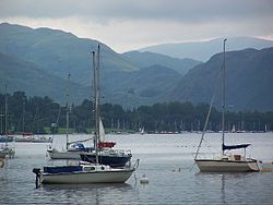
The village takes its name from a bridge over the River Eamont at the northern end of Ullswater. The bridge, erected in 1764 and replacing an earlier bridge from the 16th century, [1] collapsed on 6 December 2015 when Cumbria was hit by heavy flooding as a result of Storm Desmond. A temporary replacement bridge was opened on 20 March 2016. [2] A new stainless steel bridge was lifted into place in May 2020, [3] and opened in October 2020. [4]

There is a pier from which ferries (known as the Ullswater 'Steamers') provide connections to Glenridding and Howtown. Pooley Bridge was formerly known as Pooley or Pool How meaning the hill by the pool or stream. The name Pool How was derived from the Old English word pollr plus the Old Norse haugr meaning hill or mound. [5]

Pooley is mostly situated in the civil parish of Barton and Pooley Bridge, of which it is the main settlement. The few houses on the northern or Cumberland side of the bridge are in Dacre parish. [6] The village is popular with tourists, especially during the summer, and has several hotels, guest houses and camping sites.

Related Research Articles

Ambleside Human settlement in England

Ambleside is a town and former civil parish, now in the parish of Lakes, in Cumbria, in North West England. Historically in Westmorland, it marks the head of Windermere, England's largest natural lake. In the Lake District National Park, it is south of the highest road pass in the Lake District, Kirkstone Pass and both places are the meeting point of well-marked paths and mountain hiking trails. In 2020 it had an estimated population of 2596. In 1961 the parish had a population of 2562.

Windermere, Cumbria (town) Human settlement in England

Windermere is a town and civil parish in the South Lakeland District of Cumbria, England. In the 2001 census the parish had a population of 8,245, increasing at the 2011 census to 8,359. It lies about half a mile (1 km) east of the lake, Windermere. Although the town Windermere does not touch the lake, it has now grown together with the older lakeside town of Bowness-on-Windermere, though the two retain distinguishable town centres. Tourism is popular in the town owing to its proximity to the lake and local scenery. Boats from the piers in Bowness sail around the lake, many calling at Ambleside or at Lakeside where there is a restored railway. Windermere Hotel opened at the same time as the railway.

Penrith, Cumbria Market town in Cumbria, England

Penrith is a market town and civil parish in the county of Cumbria, England, less than 3 miles (5 km) outside the Lake District National Park. It had a population of 15,181 at the 2011 Census. Historically in Cumberland, Penrith's local authority is currently Eden District Council, which is based in the town, as were the defunct Penrith Urban and Rural District councils. From 1974 to 2015, it was an unparished area with no local council, but a civil parish was reintroduced as Penrith Town Council and first elected on 7 May 2015.

Ullswater Lake in Cumbria, England

Ullswater is the second largest lake in the English Lake District, being about 9 miles (14 km) long and 0.75 miles (1 km) wide, with a maximum depth a little over 60 metres (197 ft). It was scooped out by a glacier in the Last Ice Age.

River Eamont River in Cumbria, England

The River Eamont is a river in Cumbria, England and one of the major tributaries of the River Eden. The name of the river is from Old English (ēa-gemōt) and is a back formation from Eamont Bridge which means the junction of streams.

Aira Force

Aira Force is a waterfall in the English Lake District, in the civil parish of Matterdale and the county of Cumbria. The site of the waterfall is owned by the National Trust.

Staveley, Cumbria Human settlement in England

Staveley is a village in the South Lakeland district, in Cumbria, England. Historically part of Westmorland, it is situated 4 miles (6 km) northwest of Kendal where the River Kent is joined by its tributary the Gowan. It is also known as Staveley-in-Westmorland and Staveley-in-Kendal to distinguish it from Staveley-in-Cartmel. There are three civil parishes – Nether Staveley, Over Staveley and Hugill (part). Their total population at the 2011 Census was 1,593 but this includes those living in the hamlet of Ings in Hugill parish.

Patterdale Human settlement in England

Patterdale is a small village and civil parish in the eastern part of the English Lake District in the Eden District of Cumbria, in the traditional county of Westmorland, and the long valley in which they are found, also called the Ullswater Valley. The parish had a population of 460 in 2001, increasing to 501 at the 2011 Census.

Glenridding Human settlement in England

Glenridding is a village at the southern end of Ullswater, in the English Lake District. The village is popular with mountain walkers who can scale England's third-highest mountain, Helvellyn, and many other challenging peaks from there.

Hart Side

Hart Side is a subsidiary top on one of the east ridges of Stybarrow Dodd, which is a mountain in the English Lake District, west of Ullswater on the main Helvellyn ridge in the Eastern Fells. With a height of 2,480 feet (756 m) Hart Side rises above the col separating it from Green Side by 75 feet (23 m).

Far Eastern Fells

The Far Eastern Fells are a group of hills in the English Lake District. Reaching their highest point at High Street, they occupy a broad area to the east of Ullswater and Kirkstone Pass. Much quieter than the central areas of Lakeland they offer in general easier walking as the fells merge mainly into the surrounding moorlands.

MV <i>Lady Wakefield</i>

The MV Lady Wakefield is a twin screw passenger vessel, operating between Glenridding, Howtown and Pooley Bridge on Ullswater in the Lake District for Ullswater Navigation and Transit Co, marketed as Ullswater 'Steamers'.

Howtown Hamlet in Cumbria, England

Howtown is a hamlet in Cumbria, England, situated at a small harbour on the east shore of Ullswater in the Lake District. It lies within the civil parish of Martindale.

Sebergham Human settlement in England

Sebergham is a small village and civil parish in the English county of Cumbria. It is located on the B5305, south of Carlisle and south-east of Wigton. The civil parish population at the 2011 Census was 365.

Ullswater Steamers Business operating boats on Ullswater in the English Lake District

Ullswater 'Steamers' is a boat company which provides leisure trips on Ullswater in the north-eastern part of the English Lake District. It is based in Glenridding, Cumbria. Founded in 1855, it currently operates five diesel powered vessels between four locations on the lake. The oldest boat in its fleet was launched in 1877.

Storm Desmond Extratropical cyclone in December 2015

Storm Desmond was an extratropical cyclone and fourth named storm of the 2015–16 UK and Ireland windstorm season, notable for directing a plume of moist air, known as an atmospheric river, which brought record amounts of orographic rainfall to upland areas of northern Atlantic Europe and subsequent major floods.

2015–16 Great Britain and Ireland floods flooding in Great Britain and Ireland during the winter of late 2015 and early 2016

The 2015–2016 Great Britain and Ireland floods were a series of heavy rainfall events which led to flooding during the winter of late 2015 and early 2016. 11 named storms produced record level rainfall from November 2015 - March 2016 in both monthly and seasonal accumulation records.

Pooley Bridge (structure)

Pooley Bridge was an historic stone road bridge that crossed the River Eamont in the village of Pooley Bridge near the northern end of Ullswater. It connected two civil parishes, Barton and Pooley Bridge and Dacre, and was grade II listed in January 1991.

Ullswater Way

The Ullswater Way is a 20-mile (32 km) waymarked walking route around Ullswater in the English Lake District. It was created by a partnership which included The Lake District National Park Authority, the National Trust, Eden District Council, and Ullswater 'Steamers' and was opened on 25 April 2016 by broadcaster and film-maker Eric Robson. The idea of a path circumnavigating the lake had been considered for many years, but the 2015 Cumbria floods which devastated the area gave an incentive for the completion of the project.

Barton and Pooley Bridge Civil parish in Cumbria, England

Barton and Pooley Bridge is a civil parish in Eden District, Cumbria, England. The parish is on the edge of the Lake District National Park, and had a population of 232 according to the 2001 census, increasing slightly to 238 at the 2011 Census. The parish includes the village of Pooley Bridge, the small hamlet of Barton, and part of Ullswater, and extends south as far as Loadpot Hill. It has an area of 16.95 square kilometres (6.54 sq mi) and a 2011 population density of 14/sqkm (36/sqmi). The parish was renamed from "Barton" to "Barton and Pooley Bridge" on 1 April 2019.

References

  1. "Pooley Bridge, Cumbria". Britain Express. Retrieved 6 December 2015.
  2. "Celebration as Pooley Bridge opens". ITV News. 20 March 2016. Retrieved 16 June 2016.
  3. "Washed away bridge replacement lifted into place". BBC News. 7 May 2020. Retrieved 8 May 2020.
  4. Wainwright, Oliver (22 November 2020). "Sheep and Land Rovers rejoice: Pooley Bridge reunites the Lake District". The Observer . Retrieved 23 November 2020.
  5. Towns, Villages, Hamlets and Farms Place Names in the Lake District Archived 2008-05-04 at the Wayback Machine
    - Towns and Villages of Cumbria
  6. Lake District Lets Go Illustrated details