Rockhampton is a village and civil parish in the English county of Gloucestershire, situated in the unitary district of South Gloucestershire. It is located 2.8 miles (4.5 km) northeast of Thornbury, 18.6 miles (29.9 km) north of Bristol and is approximately 4 miles (6.4 km) east of the River Severn. It had a population of 166 people according to the 2011 census.

Lorton, a parish in Cumberland, Cumbria, England, consists of two adjacent villages: Low Lorton and High Lorton. Both nestle at the northern end of the Vale of Lorton, surrounded by fells such as Grasmoor, Hopegill Head and Whiteside. They are about 4 miles (6.5 km) from Cockermouth, which gives access to the main A66 road. Other nearby places include Loweswater and Brigham.

Hill is a village and civil parish in South Gloucestershire, England, midway between the towns of Thornbury in South Gloucestershire and Berkeley in Gloucestershire. The parish stretches from the banks of the River Severn to an outcrop of the Cotswolds escarpment. At the 2001 census, it had a population of 114. Hill is approximately 5 miles from the M5 motorway which links to Gloucester, Cheltenham and Bristol.

Blawith and Subberthwaite is a civil parish in the Westmorland and Furness Unitary Authority of Cumbria, England. It is situated in the Lake District National Park, and includes the villages of Blawith and Subberthwaite. In the 2001 census the parish had a population of 189. At the 2011 census Blawith and Subberthwaite was grouped with Torver giving a total population of 265.

Borough Fen is a civil parish in the City of Peterborough unitary authority in Cambridgeshire, England. The parish is to the north of Peterborough city centre, just below the county border with Lincolnshire. Much of the land in the 19th century was owned by Sir Culling Eardley, 3rd Baronet, a strong supporter of the local boys' school. The land has predominantly been used for agriculture and cattle farming which is still a significant employment sector today.
Described by John Marius Wilson in 1870 as "BOROUGH-FEN (Ville), an extra-parochial tract in Peterborough district, Northampton; 5 miles N by E of Peterborough. Acres, 3,130. Real property, £6,086. Pop., 202. Houses, 31."
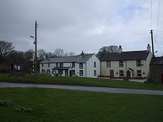
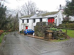
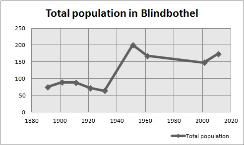
Bothel and Threapland is a civil parish in Cumbria, England, just outside the Lake District National Park. According to the 2001 census, it had a population of 438. The parish includes the villages of Bothel and Threapland. The village of Bothel is south-east of the parish of Aspatria and Threapland is south of Aspatria and Carlisle is eighteen miles (29 km) North-east of the parish. It had a population of 483 in the 2011 census figures.

Gayles is a village and civil parish in the Richmondshire district of North Yorkshire, England. Gayles is established in the district ward of Gilling West. This small village consists of 80 households, with a total population of 180 according to the 2011 UK census. The area also includes two farms by the names of Gayles Hall Farm and Slip Farm. The village is roughly 10 miles (16 km) west of Darlington.

Greysouthen is a village and civil parish between the towns of Workington and Cockermouth, in Cumbria, North West England, historically part of Cumberland, near the Lake District National Park. The village has an historic association with coal mining.

Bridekirk is a village and civil parish in the Cumberland district in the county of Cumbria, England. It is around 3.2 kilometres (2 mi) north of the Derwent river and about the same distance from the nearest large town of Cockermouth just south of the river. Bridekirk is just outside the Lake District National Park and is not far from the Maryport and Carlisle Railway.

Leathley is a village and civil parish in the Harrogate district of North Yorkshire, England, the parish includes the townships of both Castley and Leathley. It is near the border with West Yorkshire and the River Wharfe, 1 mile north-east of Otley. The B6161 runs through the village, connecting Leathley with Killinghall in the North and Pool-in-Wharfedale in the south.
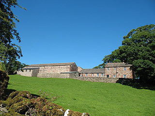
Hartley is a village and civil parish in the Westmorland and Furness district of Cumbria, England. It is about 0.5 miles (0.8 km) east of Kirkby Stephen. The area has many old lead and copper mines that are now abandoned as well as a large quantity of iron haematite, ironstone and ore. At the highest peak in Hartley stand nine obelisks referred to as "Nine Standards". Nobody knows the true purpose of the "Nine Standards" although some believe that they were used to create a sense of a forthcoming army to scare the enemy forces. However, it is more widely believed that they were placed as geographical aid to help outline the borders between the two neighbouring counties, Westmorland and Yorkshire. Hartley is also home to Hartley Castle. It was originally built as a "tower house circa 1353 and extended circa 1600" and then re- developed in the 18th century. The castle was built at the southern point of Hartley.

Pennington is a small village and civil parish in Furness, a region of Cumbria, England. Pennington lies between Ulverston, Rosside and Lindal. Pennington is located just off the nearby A590, with the nearest railway link in Ulverston.

Ulceby with Fordington is a civil parish in the East Lindsey district of Lincolnshire, England. The parish is situated 27 miles (43 km) east from the city and county town of Lincoln and 3 miles (5 km) south-west from Alford. The A1028 road runs through the parish.

Rochford consists of two hamlets, Lower and Upper Rochford. A civil parish in the Malvern Hills District near Tenbury Wells, in the county of Worcestershire, England, Rochford is 18 miles (29 km) NW of Worcester. The River Teme, which rises in Wales, flows past Lower Rochford and joins the River Severn in Worcester. The chapelry of Rochford was an exclave of Herefordshire, part of the hundred of Wolphy. It was transferred by the Counties Act 1844 to Worcestershire.

Gilcrux is a small village and civil parish in the ceremonial county of Cumbria, England, and historically part of Cumberland. It is situated just outside the Lake District National Park.

Haile is a small village and civil parish in Cumberland district, in the county of Cumbria, England. It had a population of 617 at the 2011 census.

Kirton is a village and civil parish in the East Suffolk district, in the county of Suffolk, England, situated off the A14 road, about 4.5 km (2.8 mi) from Felixstowe and around 10 km (6.2 mi) from Ipswich. The closest train station to Kirton is Trimley. According to the 2011 census, Kirton had a population of 1,146. It is located between the River Deben and the River Orwell. The village of Kirton covers a total area of 8.3 km2 (3.2 sq mi). As the county of Suffolk lacks quarries, many of the buildings are made from flint, clay and timber.

Shottisham is a village and civil parish in the East Suffolk district, in the county of Suffolk. It lies in the Wilford Hundred, about four and a half miles south-east of Woodbridge, between the parishes of Sutton, Alderton, Ramsholt and Hollesley, in the Bawdsey peninsula. About three miles from the coast at Hollesley Bay and Shingle Street, the village street overlooks a slight hollow of meads and copses at the road crossing of Shottisham Creek, a tributary brook of the river Deben.

Hayton is a village in the Cumberland unitary authority area of Cumbria, England. It is the only settlement in the civil parish of Hayton and Mealo. Historically located in Cumberland, and on a minor road between the B5300 and the A596, it is approximately 2 miles from the coast. Nearby settlements include the town of Aspatria and the villages of Oughterside and Prospect. A small tributary called Patten Beck runs across the village, through the grounds of the castle.
Poughill is a village and civil parish in the Mid Devon district, in the county of Devon, England. It lies 5 miles (8 km) north of Crediton. In 2011, the parish had a population of 216.