Crosthwaite

Last updated

Crosthwaite
Crosthwaite St Mary.jpg
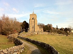
St Mary's Church, Crosthwaite
Location map United Kingdom South Lakeland.svg
Red pog.svg
Crosthwaite
Location in South Lakeland
Cumbria UK location map.svg
Red pog.svg
Crosthwaite
Location within Cumbria
OS grid reference SD437914
Civil parish
District
Shire county
Region
Country England
Sovereign state United Kingdom
Post town Kendal
Postcode district LA8
Dialling code 015395
Police Cumbria
Fire Cumbria
Ambulance North West
UK Parliament
List of places
UK
England
Cumbria
54°18′58″N2°51′56″W / 54.316022°N 2.865457°W / 54.316022; -2.865457 Coordinates: 54°18′58″N2°51′56″W / 54.316022°N 2.865457°W / 54.316022; -2.865457

Crosthwaite is a small village located in the Parish of Crosthwaite and Lyth, South Lakeland, Cumbria, England. It is in the Lake District National Park. [1]

Contents

Village hall

The Argles Memorial Hall was built in 1931 [2] on land donated from the local landowners. It underwent a major refurbishment in 2003 and is currently used by The Exchange, children's playgroups and keep fit classes.

Exchange

The Crosthwaite Exchange was set up in February 2007 [2] as a place for local people to buy and sell local produce, home baked goods, books, and meet up with other villagers. Since then, the exchange has been used by the NHS as a model for exchanges in other villages. [3]

St Mary's Parish Church

Crosthwaite is home to the St Mary's Parish Church. The first reference to a place of worship was in a 12th-century grant of land. [4]

See also

Related Research Articles

Cumbria Ceremonial county of England

Cumbria is a ceremonial and non-metropolitan county in North West England. The county and Cumbria County Council, its local government, came into existence in 1974 after the passage of the Local Government Act 1972. Cumbria's county town is Carlisle, in the north of the county. The only other major urban area is Barrow-in-Furness on the south-western tip of the county.

Ulverston Market town in Cumbria, England

Ulverston is a market town and a civil parish in the South Lakeland district of Cumbria, England. In the 2001 census the parish had a population of 11,524, increasing at the 2011 census to 11,678. Historically in Lancashire, it lies a few miles south of the Lake District National Park and just north-west of Morecambe Bay, within the Furness Peninsula. Lancaster is 51 miles (82 km) to the east, Barrow-in-Furness 8 miles (13 km) to the south-west and Kendal 33 miles (53 km) to the north-east.

Keswick, Cumbria Town and parish in the English Lake District National Park

Keswick is an English market town and a civil parish, historically in Cumberland, and since 1974 in the Borough of Allerdale in Cumbria. Lying within the Lake District National Park, Keswick is just north of Derwentwater and is 4 miles (6.4 km) from Bassenthwaite Lake. It had a population of 5,243 at the 2011 census.

Barrow-in-Furness Town in Cumbria, North-West England

Barrow-in-Furness is a town in Cumbria, North-West England. Historically part of Lancashire, it was incorporated as a municipal borough in 1867 and merged with Dalton-in-Furness Urban District in 1974 to form the Borough of Barrow-in-Furness. At the tip of the Furness peninsula, close to the Lake District, it is bordered by Morecambe Bay, the Duddon Estuary and the Irish Sea. In 2011, Barrow's population was 57,000, making it the second largest urban area in Cumbria after Carlisle. Natives of Barrow, as well as the local dialect, are known as Barrovian.

Penrith, Cumbria Market town in Cumbria, England

Penrith is a market town and civil parish in the county of Cumbria, England, less than 3 miles (5 km) outside the Lake District National Park. It had a population of 15,181 at the 2011 Census. Historically in Cumberland, Penrith's local authority is currently Eden District Council, which is based in the town, as were the defunct Penrith Urban and Rural District councils. From 1974 to 2015, it was an unparished area with no local council, but a civil parish was reintroduced as Penrith Town Council and first elected on 7 May 2015.

City of Carlisle City and non-metropolitan district in Cumbria, England

The City of Carlisle is a local government district of Cumbria, England, with the status of a city and non-metropolitan district. It is named after its largest settlement, Carlisle, but covers a far larger area which includes the towns of Brampton and Longtown, as well as outlying villages including Dalston, Scotby and Wetheral. In 2011 the district had a population of 107,524, and an area of 1,039.97 square kilometres (402 sq mi).

Burton-in-Kendal Human settlement in England

Burton-in-Kendal is a village and civil parish on the extreme southern edge of Cumbria, England. The parish contains around 660 houses and in the 2001 census had a population of 1,411, increasing at the 2011 census to 1,497. Historically within the county of Westmorland, the village straddles the A6070 road between Crooklands and Carnforth, at a point around midway between Lancaster and Kendal, and is in the shadow of the nearby limestone outcrop known as Farleton Knott.

Coniston, Cumbria Human settlement in England

Coniston is a village and civil parish in the Furness region of Cumbria, England. In the 2001 census the parish had a population of 1,058, decreasing at the 2011 census to 928. Historically part of Lancashire, it is in the southern part of the Lake District National Park, between Coniston Water, the third longest lake in the Lake District, and Coniston Old Man.

Barton, Cumbria Hamlet in the civil parish of Barton and Pooley Bridge, in the Eden district of Cumbria, England

Barton is a hamlet in the civil parish of Barton and Pooley Bridge, in the Eden district of Cumbria, England. The parish is on the edge of the Lake District National Park, and had a population of 232 according to the 2001 census, increasing slightly to 238 at the 2011 Census. The parish includes the small hamlet of Barton, the village of Pooley Bridge and part of Ullswater. The parish was renamed from "Barton" to "Barton and Pooley Bridge" on the 1st of April 2019.

Keswick School of Industrial Art School

Keswick School of Industrial Art (KSIA) was founded in 1884 by Canon Hardwicke Rawnsley and his wife Edith as an evening class in woodwork and repoussé metalwork at the Crosthwaite Parish Rooms, in Keswick, Cumbria. The enterprise, designed to alleviate unemployment, prospered, and within ten years more than a hundred men were attending classes. A new building was erected for the school at a nearby site.

Glenridding Human settlement in England

Glenridding is a village at the southern end of Ullswater, in the English Lake District. The village is popular with mountain walkers who can scale England's third-highest mountain, Helvellyn, and many other challenging peaks from there.

Askam and Ireleth Human settlement in England

Askam and Ireleth is a civil parish close to Barrow-in-Furness in the county of Cumbria, in North West England. Historically part of Lancashire, it originally consisted of two separate coastal villages with different origins and histories which, in recent times, have merged to become one continuous settlement. In the 2001 census the parish had a population of 3,632, reducing at the 2011 census to 3,462.

Cartmel Fell Human settlement in England

Cartmel Fell is a hamlet and a civil parish in the South Lakeland district of Cumbria, England. In the 2001 census the parish had a population of 309, increasing at the 2011 census to 329. The village of Cartmel and Cartmel Priory are not in this parish but in Lower Allithwaite, to the south: Cartmel Fell church is about 7 miles north of Cartmel Priory.

Portinscale Human settlement in England

Portinscale is a village in Cumbria, England, close to the western shore of Derwentwater in the Lake District National Park 1.5 miles (2.4 km) from Keswick.

Dean, Cumbria Human settlement in England

Dean is a village and civil parish in the Allerdale district, in the county of Cumbria, England. Dean has a Church of England school, a church called St Oswald's. Nearby settlements include the towns of Workington and Cockermouth.

Crosthwaite and Lyth Human settlement in England

Crosthwaite and Lyth is a civil parish in the South Lakeland district of Cumbria, England. In the 2001 census the parish had a population of 562, increasing at the 2011 census to 618.

Crosthwaite may refer to:

Cowmire Hall

Cowmire Hall is a country house near Crosthwaite in Cumbria, England. The hall, the garden wall and gate piers are recorded in the National Heritage List for England as a designated Grade II* listed building.

Crosthwaite and Lyth is a civil parish in the South Lakeland District of Cumbria, England. It contains 37 listed buildings that are recorded in the National Heritage List for England. Of these, one is listed at Grade II*, the middle of the three grades, and the others are at Grade II, the lowest grade. The parish is in the Lake District National Park. It contains the villages and smaller settlements of Crosthwaite, Crosthwaite Green and Rowe, and is otherwise rural. Most of the listed buildings are houses and associated structures, farmhouses and farm buildings. The other listed buildings include bridges, limekilns, a corn mill and ancillary buildings, a former school, a mill dam and associated structures, and a church.

Lyth may refer to:

References

  1. "Lake District National Park overview map" (PDF). Natural England. 2015. Retrieved 26 November 2018.
  2. 1 2 "Crosthwaite and Lyth Parish Plan" (PDF). February 2007. Archived from the original (PDF) on 27 July 2011.
  3. "NHS Cumbria inspired by Crosthwaite Exchange" (PDF). 2 March 2009. Archived from the original (PDF) on 27 July 2011.
  4. Pam Bownass; Penny Mutch; Hartley Trotter; John Wilson. Cameos of Crosthwaite and Lyth. ISBN   0-9544537-0-0.

Location Grid