Watermillock | |
---|---|
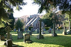
Parish Church of All Saints, Watermillock | |
OS grid reference | NY445224 |
Civil parish | |
Unitary authority | |
Ceremonial county | |
Region | |
Country | England |
Sovereign state | United Kingdom |
Post town | PENRITH |
Postcode district | CA11 |
Dialling code | 017684 |
Police | Cumbria |
Fire | Cumbria |
Ambulance | North West |
UK Parliament | |
Watermillock is a village and former civil parish, now in the parish of Matterdale, in the Westmorland and Furness district, in the ceremonial county of Cumbria, England. It is on the western shore of Ullswater, in the English Lake District. In 1931 the civil parish had a population of 448. [1] On 1 April 1934 the civil parish was merged into Matterdale. [2]
The settlement is popular with tourists, with several campsites and two hotels. [3] [4] The village and outlying farms are widely scattered between the lake and Little Mell Fell. Much of the high ground around the village was once deer forest, popular with the local gentry for hunting. All Saints Church, Watermillock was built in 1881 of slate and red sandstone, replacing an earlier church at the site of what is now known as the Old Church Hotel. All the windows are memorials to various people, including Cecil Spring Rice and Stephen Spring Rice, who grew up in the village.[ citation needed ]
The village is accessed by the A592 road. [5] The Outward Bound Trust own the village manor next to the lake. The waterfall of Aira Force is situated to the west of the village.[ citation needed ]
Ambleside is a town and former civil parish, now in the parish of Lakes, in Westmorland and Furness, Cumbria, England, The town was historically in Westmorland. Located in the Lake District National Park, the town sits at the head of Windermere, England's largest natural lake. In 2020 it had an estimated population of 2596.
Tallentire is a village and former civil parish, now in the parish of Bridekirk, in the Cumberland district of Cumbria, England. It is about 2.5 miles (4.0 km) north of Cockermouth. The village is located just outside the Lake District National Park. In 1931 the parish had a population of 184.
Little Salkeld is a small village and former civil parish, now in the parish of Hunsonby, in the Eden district of Cumbria, England, a few miles to the north east of Penrith. In 1931 the civil parish had a population of 91.
Dalton is a hamlet and former civil parish, now in the parish of Burton-in-Kendal, in the Westmorland and Furness district, Cumbria, England. Until 1894 it was in Lancashire, but was transferred to Westmorland "in accordance with the unanimous desire of the inhabitants". In 1961 the parish had a population of 99. Dalton was formerly a township in Burton-in-Kendal parish, from 1866 Dalton was a civil parish in its own right until it was abolished on 1 April 1986 and merged with Burton to form "Burton-in-Kendal".
Troutbeck is a village and former civil parish, now in the parish of Lakes, in Westmorland and Furness unitary authority in the ceremonial county of Cumbria, England. It is 3 miles (5 km) north of Windermere town, and west of the A592 road, in the valley of Trout Beck. It is a conservation area and includes the National Trust property of Townend. In 1961 the parish had a population of 592.
Brackenthwaite is a settlement and former civil parish, now in the parish of Buttermere, in the unitary authority area of Cumberland, in the ceremonial county of Cumbria, England. It is situated some 6 miles (9.7 km) south of Cockermouth. It should not be confused with the identically named settlement of Brackenthwaite that is situated some 3 miles (4.8 km) south-east of the town of Wigton in the same county. In 1931 the parish had a population of 89.
Gamblesby is a village near Melmerby, and former civil parish, now in the parish of Glassonby, in the Westmorland and Furness district, in the ceremonial county of Cumbria, England. It appears first in written records in 1177 as Gamelesbi, and in 1212 as Gamelesby. Originally a township of the ancient parish of Addingham, Gamblesby was a civil parish in its own right from 1866 until 1934. In 1931 the parish had a population of 197.
Farleton is a village and former civil parish, now in the parish of Beetham, in the South Lakeland local government district, Cumbria, England. In 1931 the parish had a population of 67.
Little Musgrave is a small village and former civil parish, now in the parish of Musgrave, in the Eden district of Cumbria, England. In 1891 the parish had a population of 52.
Great Broughton is a village and former civil parish, now in the parish of Broughton, in the Cumberland district, in the ceremonial county of Cumbria, England. It caters strongly for visitors. The estimated resident population was 1,823 in 2017.
Eaglesfield is a village in the parish of Dean in Cumberland in Cumbria, England. It is near the A5086 road, 2.5 miles (4 km) southwest of Cockermouth and is located just outside the Lake District National Park. In 1931 the parish had a population of 233.
Witherslack is a small village and former civil parish, now in the parish of Witherslack, Meathop and Ulpha, in the Westmorland and Furness district, in the south of Cumbria, England. It lies on the north eastern side of Morecambe Bay, England. The eastern side of the village borders Whitbarrow Scar with Yewbarrow, which is a small limestone hill, located in the centre of the village.
Sunderland is a hamlet and former civil parish, within the Lake District National Park, now in the parish of Blindcrake in the Allerdale district of the county of Cumbria, England, historically part of Cumberland. In 1931 the parish had a population of 60.
Oulton is a hamlet and former civil parish, now in the parish of Woodside, near the small town of Wigton, in the Allerdale district of the county of Cumbria, England. In 1931 the civil parish had a population of 271. Oulton was formerly a township in Wigton parish, from 1866 Oulton was a civil parish in its own right until it was abolished on 1 April 1934 and merged into Woodside.
Matterdale is a civil parish in the Lake District of Cumbria, England. It lies on the northern shore of Ullswater. The parish includes the settlements of Dockray, Matterdale End, Ulcat row, Watermillock and Wreay. It had a population of 526 in 2001, reducing to 483 at the 2011 Census.
Mosedale is a hamlet and former civil parish, now in the parish of Mungrisdale in the Eden district, in the county of Cumbria, in the north west of the English Lake District. It is on the River Caldew, north east of Bowscale Fell and south east of Carrock Fell, about one mile north of Mungrisdale. In 1931 the parish had a population of 49. In the 2011 United Kingdom census the parish of Mungrisdale, comprising eight hamlets including Mosedale, had a population of 297.
All Saints Church is a Grade II listed Church of England parish church in the village of Watermillock, Cumbria. It serves the scattered settlement of Watermillock, as well as outlying farms and hamlets on the northern shore of Ullswater.
St John's, Castlerigg and Wythburn is a civil parish in Allerdale district, Cumbria, England. In the 2011 census it was recorded as having a population of 422. There is a parish council; its archives 1894–1995 are held at the Cumbria Archive Service in Carlisle. in 2004 a parish plan was drawn up and approved by the parish council.
Matterdale is a civil parish in the Eden District, Cumbria, England. It contains 33 listed buildings that are recorded in the National Heritage List for England. Of these, three are listed at Grade II*, the middle of the three grades, and the others are at Grade II, the lowest grade. The parish is in the Lake District National Park. It contains the settlements of Watermillock, Matterdale End, Wreay, Dockray, and Hutton, and apart from that it is mainly rural comprising countryside, moorland and fells.
Stainburn is a settlement and former civil parish about 7 miles from Whitehaven, now in the parish of Workington, in the county of Cumbria, England. In 2018 the built-up area had an estimated population of 1705. Stainburn was also a ward, in 2011 the ward had a population of 1694. In 1961 the parish had a population of 246. Stainburn was on the A66 road until 20 December 2002 when it was bypassed.