
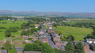
Kirkby Lonsdale is a town and civil parish in the Westmorland and Furness district of Cumbria, England, on the River Lune. Historically in Westmorland, it lies 13 miles (21 km) south-east of Kendal on the A65. The parish recorded a population of 1,771 in the 2001 census, increasing to 1,843 at the 2011 Census.

South Lakeland was a local government district in Cumbria, England, from 1974 to 2023. Its council was based in Kendal. The district covered the southern part of the Lake District region, as well as northwestern parts of the Yorkshire Dales. At the 2011 Census, the population of the district was 103,658, an increase from 102,301 at the 2001 Census.

Milnthorpe is a village, civil parish, and former market town in Westmorland and Furness, Cumbria, England. It is 7 miles (11 km) south of Kendal. Historically in the county of Westmorland and on the A6, the village contains several old hostelries and hosts a market every Friday. The parish, which includes the village of Ackenthwaite, had a population of 2,199 according to the 2011 Census.

Kirkby Stephen is a market town and civil parish in Cumbria, England. It lies on the A685 and is surrounded by sparsely populated hill country, about 25 miles (40 km) from the nearest larger towns, Kendal and Penrith. The River Eden rises 6 miles (10 km) away in the peat bogs below Hugh Seat and passes the eastern edge of the town. At the 2001 census the parish had a population of 1,832. In 2011, it had a population of 1,522.
Sedbergh is a town and civil parish in the ceremonial county of Cumbria. It falls within the historic boundaries of the West Riding of Yorkshire. Since April 2023, it has been administered by Westmorland and Furness local authority. The 2001 census gave the parish a population of 2,705, increasing at the 2011 census to 2,765. It lies about 10 miles (16 km) east of Kendal, 28 miles (45 km) north of Lancaster and about 10 miles (16 km) north of Kirkby Lonsdale, within the Yorkshire Dales National Park. It stands at the foot of Howgill Fells, on the north bank of the River Rawthey, which joins the River Lune 2 miles (3 km) below the town.

Tebay is a village and civil parish in Cumbria, England, within the historic borders of Westmorland. It lies in the upper Lune Valley, at the head of the Lune Gorge. The parish had a population of 728 in the 2001 census, increasing to 776 at the Census 2011.

Ravenstonedale is a village and large civil parish in Cumbria, on the watershed between the River Lune and River Eden. The village lies 4 miles (6 km) south west of Kirkby Stephen. The parish includes the village of Newbiggin-on-Lune and several smaller settlements including Bowderdale, Brownber, Greenside, Stennerskeugh, Wath and Weasdale. Large areas of moorland lie within the parish, extending 5 miles (8 km) south west of the village to the northern side of the Howgill Fells. The parish had a population of 570 in 2001, increasing to 594 at the 2011 Census.

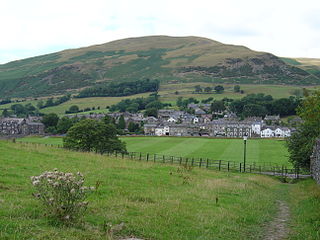
Barbon is a village and civil parish in Cumbria, England. According to the 2001 census it had a population of 263, which decreased to 236 according to the 2011 Census. The church is dedicated to St Bartholomew. The village is about 3 miles (4.8 km) north of Kirkby Lonsdale and 2 miles (3.2 km) north of Casterton. Barbon Beck flows through, and takes its name from the village before flowing into the River Lune. The A683 road passes to the west of the village between Kirkby Lonsdale and Sedbergh. The village has been within the Yorkshire Dales National Park since 1 August 2016.

Brough, sometimes known as Brough under Stainmore, is a village and civil parish in the historic county of Westmorland and the ceremonial county of Cumbria, England, within the Westmorland and Furness unitary authority area, on the western fringe of the Pennines near Stainmore. The village is on the A66 trans-Pennine road, and the Swindale Beck, and is about 8 miles (13 km) south east of Appleby-in-Westmorland. Brough is situated 5 miles (8.0 km) north east of Kirkby Stephen and 28 miles (45 km) north east of Kendal on the A685.
Kirkby Thore is a small village and civil parish in Cumbria, England, in the historic county of Westmorland. It is close to the Lake District national park and the Cumbrian Pennines. It includes the areas of Bridge End, in the southwest by the A66, and Cross End in the northeast of the village. In the 2001 census, the parish had a population of 731, increasing to 758 in the 2011 Census. The market town of Appleby-in-Westmorland is about five miles away, and the larger town of Penrith is about eight miles away.

Cowan Bridge is a village in the English county of Lancashire.

Hutton Roof is a village and civil parish in the Westmorland and Furness district of Cumbria, England, close to Kirkby Lonsdale and Hutton Roof Crags. Historically in Westmorland, the parish includes the hamlet of Newbiggin. In the 2001 census the parish had a population of 193, increasing at the 2011 census to 218.

Mansergh is a village and civil parish in the Westmorland and Furness district of the English county of Cumbria. It includes the village of Mansergh and the hamlet of Old Town, and is located 3.3 miles (5.3 km) north of Kirkby Lonsdale, 9.8 miles (15.8 km) south east of Kendal and 53.2 miles (85.6 km) south of Carlisle. In the 2001 census the parish had a population of 141, decreasing at the 2011 census to 124.

Holy Trinity Church is in the village of Casterton, Cumbria, England. It is an active Anglican parish church in the deanery of Kendal, the archdeaconry of Westmorland and Furness, and the diocese of Carlisle. Its benefice is united with those of five local parishes, the benefice being entitled Kirkby Lonsdale Team Ministry. The church is recorded in the National Heritage List for England as a designated Grade II listed building.

St Bartholomew's Church is in the village of Barbon, Cumbria, England. It is an active Anglican parish church in the deanery of Kendal, the archdeaconry of Westmorland and Furness, and the diocese of Carlisle. Its benefice is united with those of St Mary the Virgin, Kirkby Lonsdale, Holy Trinity, Casterton, St John the Divine, Hutton Roof, All Saints, Lupton, St Peter, Mansergh, and the Holy Ghost, Middleton, to form the Kirkby Lonsdale Team Ministry. The church is recorded in the National Heritage List for England as a designated Grade II* listed building.

Staveley-in-Cartmel is a village and civil parish in Westmorland and Furness Unitary Authority, Cumbria, England. It lies east of Newby Bridge, near the south end of Windermere, 9 miles (14 km) northeast of Ulverston. It is sometimes known as Staveley-in-Furness. Both names distinguish it from another Staveley in Cumbria. In the 2001 census the parish had a population of 428, decreasing at the 2011 census to 405.

St Mary's Church is in the town of Kirkby Lonsdale, Cumbria, England. It is an active Anglican parish church in the deanery of Kendal, the archdeaconry of Westmorland and Furness, and the diocese of Carlisle. Its benefice is united with those of six local churches to form the Kirkby Lonsdale Team Ministry. The church contains Norman architecture and is recorded in the National Heritage List for England as a designated Grade I listed building.
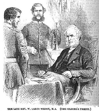
William Carus Wilson was an English churchman and the founder and editor of the long-lived monthly The Children's Friend. He was the inspiration for Mr Brocklehurst, the autocratic head of Lowood School, depicted by Charlotte Brontë in her 1847 novel Jane Eyre.

