Bewcastle

Last updated

Bewcastle
Civil parish
Bewcastle cross and church.jpg
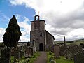
Bewcastle church and cross
Location map United Kingdom City of Carlisle.svg
Red pog.svg
Bewcastle
Location in the former City of Carlisle district
Cumbria UK location map.svg
Red pog.svg
Bewcastle
Location within Cumbria
Population391 (2011 census)
OS grid reference NY565745
Civil parish
  • Bewcastle
Unitary authority
Ceremonial county
Region
Country England
Sovereign state United Kingdom
Post town Carlisle
Postcode district CA6
Post townNewcastleton
Postcode district TD9
Dialling code 016977
Police Cumbria
Fire Cumbria
Ambulance North West
UK Parliament
Website http://www.bewcastle.com/
List of places
UK
England
Cumbria
55°03′47″N2°40′57″W / 55.06306°N 2.68261°W / 55.06306; -2.68261 Coordinates: 55°03′47″N2°40′57″W / 55.06306°N 2.68261°W / 55.06306; -2.68261

Bewcastle is a large civil parish in the Cumberland unitary authority area of Cumbria, England. It is in the historic county of Cumberland.

Contents

According to the 2001 census the parish had a population of 411, reducing to 391 at the 2011 Census. [1] The parish is large and includes the settlements of Roadhead and Sleetbeck. To the north the parish extends to the border with Scotland. To the east the parish bounds Northumberland.

Etymology

The origin of the name Bewcastle can be traced accurately from its spelling in ancient documents. These show that it was originally "bothy/booth caster", which translates as "the Roman fort where there were bothies or shielings". 'Cæster' is "an Anglian side-form of OE 'ceaster', referring to the defences of the Roman camp...a medieval fortress was built within these defences..." The original form of the first element "was clearly 'Buth-' from ON búð, 'booth'." [2] (OE=Old English; ON=Old Norse).

Antiquarians, who did not have our access to well-catalogued and studied ancient documents, leapt at the chance to link the place name with a semi-mythological figure named Bueth, due to his romantic links with the prestigious Barony of Gilsland. The well-respected book The Place-names of Cumberland [3] states that it is "impossible" for Bewcastle to be named after Bueth.

Governance

Bewcastle is in the parliamentary constituency of Penrith and the Border. Neil Hudson was elected its Conservative Member of Parliament at the 2019 General Election, replacing Rory Stewart.

Before Brexit, it was in the North West England European Parliamentary Constituency.

Church and cross

St Cuthbert's churchyard contains the famous 7th-Century Bewcastle Cross. The sundial on its surface is the oldest in Britain,[ citation needed ] divided into the four 'tides' which governed the working day in medieval times. Its importance has been described by Nikolaus Pevsner thus: "The crosses of Bewcastle and Ruthwell ... are the greatest achievement of their date in the whole of Europe." [4] A reconstruction of the whole cross is located in the churchyard of St Mary's neo-Romanesque Church at Wreay near Carlisle, but this differs in style and detail from the original. Stephen Matthews [5] calls the Wreay cross a "reinvention".

Roman Fort

The parish is also known for its unusual hexagonal Bewcastle Roman Fort, which has been identified as Fanum Cocidi; its grassy ramparts can still be seen surrounding the churchyard. The fort was originally built from turf and timber and garrisoned by the First Nervian Cohort of Germans. It was built as an outlying defence of Hadrian's Wall to the south, to which it was linked by a road direct from the Roman fort of Banna (Birdoswald) on the wall, and a signal station on Gillalees Beacon between the two. The fort was later rebuilt in stone. Much of the stone was subsequently used to build a Norman castle within the northern perimeter of the fort. The ruins of Bewcastle Castle have recently been consolidated by English Heritage, and are accessible to the public without charge. [6]

People

Two brothers born in Bewcastle, Joseph Armstrong (1816–1877) and George Armstrong (1822–1901), became noted steam locomotive engineers; their careers were spent mainly on the Great Western Railway. [7]

See also

Related Research Articles

<span class="mw-page-title-main">Carlisle</span> Cathedral city and county town of Cumbria, England

Carlisle is a city and unparished area in Cumberland, in the ceremonial county of Cumbria, England. It is the administrative centre of the unitary authority area of Cumberland, which is named after and covers a similar area to the historic county of Cumberland.

<span class="mw-page-title-main">Bewcastle Cross</span>

The Bewcastle Cross is an Anglo-Saxon cross which is still in its original position within the churchyard of St Cuthbert's church at Bewcastle, in the English county of Cumbria. The cross, which probably dates from the 7th or early 8th century, features reliefs and inscriptions in the runic alphabet. The head of the cross is missing but the remains are 14.5 feet high, and almost square in section 22 × 21¼ inches at the base. The crosses of Bewcastle and Ruthwell have been described by the scholar Nikolaus Pevsner as "the greatest achievement of their date in the whole of Europe".

<span class="mw-page-title-main">Burgh by Sands</span> Human settlement in England

Burgh by Sands is a village and civil parish in the City of Carlisle district of Cumbria, England, situated near the Solway Firth. The parish includes the village of Burgh by Sands along with Longburgh, Dykesfield, Boustead Hill, Moorhouse and Thurstonfield. It is notable as the site of the first recorded North African (Moorish) military unit in Roman Britain, garrisoning the frontier fort of Aballava on Hadrian's Wall in the 3rd century AD. It is also where Edward I of England died in 1307.

<span class="mw-page-title-main">Bewcastle Castle</span> Castle in Cumbria, England

Bewcastle Castle is a ruined castle in the parish of Bewcastle in the English county of Cumbria, a few miles from the Scottish border.

<span class="mw-page-title-main">Wreay</span> Village in Cumbria, England

Wreay is a small English village that lies on the River Petteril in today's Cumbria. The M6 motorway, A6 trunk road and West Coast Main Line railway all skirt the village.

<span class="mw-page-title-main">Bewcastle Roman Fort</span>

Bewcastle Roman Fort was built to the north of Hadrian's Wall as an outpost fort possibly intended for scouting and intelligence. The remains of the fort are situated at the village of Bewcastle, Cumbria, 7 miles (11 km) to the north of the Roman fort at Birdoswald, on Hadrian's Wall.

<span class="mw-page-title-main">Mawbray</span> A village on the Cumbrian coast in England

Mawbray is a village in the civil parish of Holme St Cuthbert in Cumbria, England. Historically part of Cumberland. It is located on the Solway Plain, 5.2 miles (8.4 km) south west of Silloth, 7.9 miles (12.7 km) north of Maryport, and 25 miles (40 km) west of Carlisle. The B5300, known locally as the "coast road" runs to the west of the village.

<span class="mw-page-title-main">St Bridget's Church, Brigham</span> Church in Cumbria, England

St Bridget's Church is in the village of Brigham, Cumbria, England. It is an active Anglican parish church in the deanery of Solway, the archdeaconry of West Cumberland, and the diocese of Carlisle. The church is recorded in the National Heritage List for England as a designated Grade I listed building.

<span class="mw-page-title-main">St Oswald's Church, Dean</span> Church in Cumbria, England

St Oswald's Church is in the village of Dean, Cumbria, England. It is an active Anglican parish church in the deanery of Derwent, the archdeaconry of West Cumberland and the diocese of Carlisle. The church is recorded in the National Heritage List for England as a designated Grade I listed building.

<span class="mw-page-title-main">Brampton Old Church</span> Church in Cumbria, England

Brampton Old Church stands about 1 mile (2 km) to the west of the town of Brampton, Cumbria, England. It was originally the parish church of Brampton but is now redundant. The church is recorded in the National Heritage List for England as a designated Grade II* listed building.

<span class="mw-page-title-main">All Saints Church, Bolton</span> Church in Cumbria, England

All Saints Church is in the village of Bolton, Cumbria, England. It is an active Anglican parish church in the deanery of Appleby, the archdeaconry of Carlisle, and the diocese of Carlisle. Its benefice is united with those of five local churches to form The Leith-Lyvennet Group of Parishes. The church is recorded in the National Heritage List for England as a designated Grade I listed building.

<span class="mw-page-title-main">St Mary's Church, Gosforth</span> Church in Cumbria, England

St Mary's Church in the village of Gosforth, Cumbria, England, is an active Anglican parish church in the deanery of Calder, the archdeaconry of West Cumberland, and the diocese of Carlisle. Its benefice is united with those of St Olaf, Wasdale Head, and St Michael, Nether Wasdale. The church is recorded in the National Heritage List for England as a designated Grade I listed building. It is associated with "a unique Viking-age assemblage" of carved stones.

<span class="mw-page-title-main">St Mary's Church, Wreay</span> Church in Wreay, United Kingdom

St Mary's Church, Wreay is the Church of England parish church of Wreay in Cumbria. It was designed by Sara Losh in about 1835 and built between 1840 and 1842. It is notable as the earliest known example in Britain of a revival of Lombard architecture. It is a Grade II* listed building.

Sara or Sarah Losh was an English architect and designer. Her biographer describes her as an antiquarian, architect and visionary. She was a landowner of Wreay, Cumberland, where her prime work, St Mary's Church, can be found. It anticipates the Arts and Crafts Movement and belongs to a group with buildings and monuments which Losh constructed.

<span class="mw-page-title-main">St Laurence's Church, Morland</span> Church in Cumbria, England

St Laurence's Church is in the village of Morland, Cumbria, England. It is an active Anglican parish church in the deanery of Appleby, the archdeaconry of Carlisle, and the diocese of Carlisle. Its benefice is united with those of St Mary, Thrimby, St Barnabas, Great Strickland, and St Cuthbert, Cliburn. The church is recorded in the National Heritage List for England as a designated Grade I listed building. It has the only Anglo-Saxon tower in Cumbria.

<span class="mw-page-title-main">St Andrew's Church, Penrith</span> Church in Cumbria, England

St Andrew's Church is in the centre of the town of Penrith, Cumbria, England. It is an active Anglican parish church in the deanery of Penrith, the archdeaconry of Carlisle, and the diocese of Carlisle. The parishes of Penrith ; St John, Newton Reigny and St John the Evangelist, Plumpton Wall are united in a single benefice. The church is recorded in the National Heritage List for England as a designated Grade I listed building. At one time St Andrew's had a chapel of ease or mission church in Brougham Street in the Penrith suburb of Castletown called St Saviours and another, All Hallows at the hamlet of Bowscar just to the north of the town.

<span class="mw-page-title-main">History of medieval Cumbria</span>

The history of medieval Cumbria has several points of interest. The region's status as a borderland coping with 400 years of warfare is one. The attitude of the English central government, at once uninterested and deeply interested, is another. As a border region, of geopolitical importance, Cumbria changed hands between the Angles, Norse, Strathclyde Brythons, Picts, Normans, Scots and English; and the emergence of the modern county is also worthy of study.

St Cuthbert Without is a civil parish in the Carlisle district of Cumbria, England. It contains 43 listed buildings that are recorded in the National Heritage List for England. Of these, two are listed at Grade II*, the middle of the three grades, and the others are at Grade II, the lowest grade. The parish includes the southern suburbs of Carlisle including Garlands, and the villages of Blackwell, Brisco, Carleton, and Wreay, together with the surrounding countryside. Most of the listed buildings are country houses, smaller houses and associated structures, farmhouses, and farm buildings. The other listed buildings include a church and associated structures, a former mortuary chapel, a former hospital chapel, and a well head.

<span class="mw-page-title-main">St Paul, Irton</span> Church in Cumbria, England

St Paul, Irton is an active parish church in the civil parish of Irton with Santon, Cumbria, England. It is in the Calder Deanery of the Anglican diocese of Carlisle and is part of the benefice of Black Combe, Drigg, Eskdale, Irton, Muncaster and Waberthwaite. It stands in a commanding position on the low ridge between Wasdale and Eskdale, and the noted 9th century Anglo-Saxon cross testifies to a long history of it being a Christian site. The church is a Grade II* Listed Building.

References

  1. "Parish population 2011" . Retrieved 24 June 2015.
  2. Armstrong, A. M.; Mawer, A.; Stenton, F. M.; Dickens, B. (1950). The place-names of Cumberland. English Place-Name Society, vol.xx. Vol. Part 1. Cambridge: Cambridge University Press. pp. 60–61.
  3. Armstrong, 1950, p..60-61
  4. Pevsner, Nikolaus (1967) The buildings of England - Cumberland and Westmorland. Penguin Books.
  5. Matthews, S. 2007. Sarah Losh and Wreay Church; Bookcase, Carlisle
  6. 'Bewcastle' in The Cumberland News supplement 6 June 2014.
  7. Marshall 1978 , pp. 13–14

Bibliography