Swineshead, Bedfordshire

Last updated

Swineshead
Swineshead highstreet.jpg
Bedfordshire UK location map.svg
Red pog.svg
Swineshead
Location within Bedfordshire
Population122 (2011 Census) [1]
OS grid reference TL057658
Unitary authority
Ceremonial county
Region
Country England
Sovereign state United Kingdom
Post town BEDFORD
Postcode district MK44
Dialling code 01234
Police Bedfordshire
Fire Bedfordshire and Luton
Ambulance East of England
UK Parliament
List of places
UK
England
Bedfordshire
52°16′50″N0°27′05″W / 52.28055°N 0.4513°W / 52.28055; -0.4513 Coordinates: 52°16′50″N0°27′05″W / 52.28055°N 0.4513°W / 52.28055; -0.4513

Swineshead is a village and civil parish in the Borough of Bedford in the county of Bedfordshire, England.

Contents

History

The parish of Swineshead is recorded as Suineshefet (1086), Swynesheved (13th century), Swineshead (16th century). It was an exclave of the county of Huntingdonshire, and surrounded by Bedfordshire, until 30 September 1896, when it was transferred to Bedfordshire. [2] [3] [4] [5] [6] The parish was an exclave because it was within the great manor of Kimbolton, once the property of Harold, the last Saxon king of England, and part of this manor was held to be in Huntingdonshire though separated from the rest of the county by about half a mile at the nearest point. Thus although King Harold's lands were granted to different persons by William the Conqueror, Swineshead and Stonely both passed to Fitz-Piers and both remained in the county of Huntingdonshire. At the time of the Domesday survey, land in Kimbolton and in Swineshead was held by William de Warenne, and his influence may have been used to keep his property in the same county.

Swineshead was enclosed by Act of Parliament in 1803.

The parish was part of Eaton Socon Rural District from 1894 to 1934, then became part of Bedford Rural District until 1974.

Geography

The soil in the parish is loam and gravelly and the sub-soil mainly blue galt. The chief crops are wheat, barley beans, and peas. The surface is undulating and is between 139 and 236 feet (42 and 72 m) above sea-level. The village itself stands at about 155 feet (47 m). The parish was once well wooded, Swineshead and Spanoak Woods in the north of the parish still remain but now are not as large as they once were. They are owned by the Woodland Trust and Swineshead Wood is a Site of Special Scientific Interest.

Religious sites

The Church of St Nicholas consists of a chancel, nave, north aisle with vestry, south aisle, west tower and south porch. The walls are coursed rubble with some pebble rubble, and with stone dressings. The roofs are covered with stone slates, tiles and lead.

The church is not mentioned in the Domesday survey of 1086, but there was a rector here before 1271. The whole church seems to have been rebuilt during the 14th century, beginning with the chancel about 1330; about the same time, the south aisle and porch were built. The north aisle with the base of a tower at its west end followed about 10 years later, but the proposed tower was almost immediately abandoned in favour of one at the west end of the nave.

Towards the end of the 15th century, a clerestory was added to the nave, a vestry was added at the east end of the north aisle, with a chamber above it, and a narrow slipway communicating with the chancel. At the same time the chancel arch was widened, rood-stairs built on the south side, and a rood-screen and loft erected.

The nave roof was repaired in 1706 and in 1841. A general restoration seems to have occurred from 1847 to 1853. The tower and spire were again repaired in 1907.

Landmarks

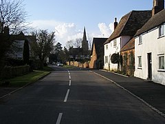
The village is in the middle of the parish, and includes many old houses. The "Three Horseshoes" Inn dates from the early 17th century. The cottages are of brick and timber with tiled and thatched roofs. The former rectory, now used as a farmhouse, is an ancient plastered building of brick and timber opposite the church. When it was undergoing restoration in 1846, a copy of the Solemn League and Covenant (signed by the then Rector of Swineshead) was discovered in the roof where it was perhaps hidden by the cautious rector of the time. There are the traces of two moats in the village.

Demography

The parish of Swineshead was in the St Neots Union for Poor Law administration. The parish occupies 1,353.5 acres (5.477 km2) of land.

Related Research Articles

<span class="mw-page-title-main">South Mimms</span> Human settlement in England

South Mimms is a village and civil parish in the Hertsmere district of Hertfordshire in the East of England. It is a small settlement located near to the junction of the M25 motorway with the A1(M) motorway.

<span class="mw-page-title-main">Winterborne Zelston</span> Human settlement in England

Winterborne Zelston is a village and civil parish in north Dorset, England. It is situated in a winterbourne valley on the A31 road eight miles south of Blandford Forum and 10 mi (16 km) northwest of Poole. The parish had a population of 141 in 2001. In 2013 the estimated population of the civil parish was 90.

<span class="mw-page-title-main">St Mary's Church, Clophill</span> Ruined church in Clophill, England

The present St Mary's Church is located in the centre of the small village of Clophill, between Bedford and Luton in the South Midlands of England. The new church, built in 1848, replaced the old church by order of the Church Commissioners in 1850. The old church building, formally The Church of St Mary The Virgin and known colloquially as Old St Mary's or The Old Parish Church, is at the edge of the village, and is estimated to be around 650 years old. It sits at the crest of the Greensand Ridge, offering views over the surrounding countryside. Its graveyard is a haven for wild flowers and wildlife. After the church moved to the village centre, incorporating various items from the old church building, the old building was converted for use as a mortuary chapel, but in the 1950s it fell into ruin.

<span class="mw-page-title-main">Littleton-upon-Severn</span> Human settlement in England

Littleton-upon-Severn is a village and former civil parish, now in the parish of Aust, in the South Gloucestershire district, in the ceremonial county of Gloucestershire, England, near the mouth of the River Severn and is located to the west of Thornbury. Historically it belonged to the Hundred of Langley and Swinehead. In 1931 the parish had a population of 179. On 1 April 1935 the parish was abolished and merged with Aust.

<span class="mw-page-title-main">Upwood</span> Human settlement in England

Upwood is a village and former civil parish, now in the parish of Upwood and the Raveleys, in the non-metropolitan district and historic county of Huntingdonshire, England, although in the administrative county of Cambridgeshire. Upwood lies approximately 7 miles (11 km) north of Huntingdon, near Bury. In 1931 the parish had a population of 322.

<span class="mw-page-title-main">Warboys</span> Human settlement in England

Warboys is a large village and civil parish in the Huntingdonshire district of Cambridgeshire, England, 7 miles (11 km) north-east of Huntingdon.

<span class="mw-page-title-main">Farcet</span> Human settlement in England

Farcet is a village and civil parish in Cambridgeshire, England. Farcet lies approximately 2 miles (3 km) south of Peterborough city centre, between Yaxley and the Peterborough suburb of Old Fletton. Farcet is situated within Huntingdonshire which is a non-metropolitan district of Cambridgeshire as well as being a historic county of England.

<span class="mw-page-title-main">Farndish</span> Human settlement in England

Farndish is a village and former civil parish, now in the parish of Podington, in the Bedford district, in northwest Bedfordshire, England, located about 500 metres (yards) east of the county border with Northamptonshire. The village is near the Northamptonshire villages of Irchester and Wollaston and the Bedfordshire village of Wymington. In 1881 the parish had a population of 72.

<span class="mw-page-title-main">Maulden</span> Human settlement in England

Maulden is a village and civil parish located in the county of Bedfordshire. The village is located 1.5 miles east of Ampthill and about 8 miles (13 km) south of Bedford. It has about 1,250 homes and 3130 residents.

<span class="mw-page-title-main">St Peter's Church, Ardingly</span> Church in West Sussex , England

St Peter's Church is the Church of England parish church of the parish of Ardingly in Mid Sussex, one of seven local government districts in the English county of West Sussex. The present building dates from the 14th century and was restored during the Victorian era, but Christian worship on the site has a much longer history. The stone-built, Decorated Gothic-style church, west of the village centre, has been designated a Grade I Listed building.

<span class="mw-page-title-main">St Andrew's Church, Woodwalton</span> Redundant church in Cambridgeshire, England

St Andrew's Church is a redundant Anglican church standing in an isolated position in fields about 2 kilometres (1.2 mi) to the north of the village of Woodwalton in Huntingdonshire, Cambridgeshire, England. It is about 200 metres (219 yd) to the east of the East Coast Main Line and is visible from the passing trains. The church is recorded in the National Heritage List for England as a designated Grade II* listed building, and is under the care of the Friends of Friendless Churches. As of 2010 it is not regularly open to visitors because its foundations are moving and it is unsafe.

<span class="mw-page-title-main">Leighton Bromswold</span> Human settlement in England

Leighton Bromswold is a small village and civil parish in Cambridgeshire, England. Leighton lies approximately 10 miles (16 km) west of Huntingdon. Leighton is situated within Huntingdonshire which is a non-metropolitan district of Cambridgeshire as well as being a historic county of England. The civil parish of which it is part is called Leighton and in 2001 had a population of 224, falling to 210 at the 2011 Census. The parish covers an area of 3,128 acres (1,266 ha).

<span class="mw-page-title-main">St Denys' Church, Little Barford</span> Church in Bedfordshire, England

St Denys' Church is a redundant Anglican church in the village of Little Barford, Bedfordshire, England. It is recorded in the National Heritage List for England as a designated Grade II* listed building, and is under the care of the Churches Conservation Trust.

<span class="mw-page-title-main">St Mary's Church, Lower Gravenhurst</span> Church in Bedfordshire, England

St Mary's Church is a redundant Anglican church in the village of Lower Gravenhurst, Bedfordshire, England. It is recorded in the National Heritage List for England as a designated Grade I listed building, and is under the care of the Churches Conservation Trust. Lower Gravenhurst is some 10 miles (16 km) southeast of Bedford, to the east of the A6 road. The church is surrounded by fields and stands on a small hill and open daily.

<span class="mw-page-title-main">All Saints Church, Conington</span> Church in Cambridgeshire, England

All Saints Church is a redundant Anglican church in the village of Conington in the Huntingdonshire district of Cambridgeshire, England. It is recorded in the National Heritage List for England as a designated Grade I listed building, and is under the care of the Churches Conservation Trust. The church stands to the east of the village, between the A1 road and the East Coast Main Line.

<span class="mw-page-title-main">Old St Peter and St Paul's Church, Albury</span> A former Anglican church in Surrey, England

Old St Peter and St Paul's Church is a former Anglican church near the village of Albury, Surrey, England in the care of The Churches Conservation Trust. It is recorded in the National Heritage List for England as a designated Grade I listed building. The church stands in Albury Park, to the northwest of Albury Hall, and between the villages of Albury and Shere.

<span class="mw-page-title-main">St Bartholomew's Church, Welby</span> Church in United Kingdom

St Bartholomew's Church is a Grade I listed Anglican church dedicated to St Bartholomew the Apostle, in the English village of Welby, Lincolnshire. It is 4 miles (6 km) north-east of Grantham, and 1 mile (1.6 km) east of High Dyke, on part of the old Ermine Street Roman road. The church is in the ecclesiastical parish and Group of Ancaster and Wilsford, in the Deanery of Loveden, and the Diocese of Lincoln.

<span class="mw-page-title-main">Church of St Mary the Virgin, Baldock</span> Church in Hertfordshire, England

The Church of St Mary the Virgin is a parish church of the Church of England in Baldock in Hertfordshire. Dedicated to the Virgin Mary, the original church on the site dated to about 1150 and was built by the Knights Templar before being largely rebuilt in about 1330 by the Knights Hospitaller. It is a Grade I listed building.

<span class="mw-page-title-main">St Andrew's Church, Old, Northamptonshire</span> Church

St Andrew's Church is an Anglican church and the parish church of Old, Northamptonshire. It is a Grade I listed building and stands at Church Lane, on the south side of the village.

<span class="mw-page-title-main">Church of St Thomas à Becket, Ramsey</span> Church in Cambridgeshire, United Kingdom

The Church of St Thomas à Becket, Ramsey is the Church of England parish church of Ramsey, Cambridgeshire. The parish is part of a benefice that includes also the parish of Upwood with Great and Little Raveley.

References

  1. "Civil Parish population 2011". Neighbourhood Statistics. Office for National Statistics. Retrieved 12 November 2016.
  2. Parishes of Swineshead and Tilbrook, Bedfordshire Times and Independent (Bedford), 22 February 1896, page 4
  3. A Transfer of Parishes, Bedfordshire Times and Independent (Bedford), 14 March 1896, page 6
  4. Beds Quarter Sessions: Alterations in the County Boundary, Bedfordshire Times and Independent (Bedford), 4 July 1896, page 6
  5. Annual Report of the Local Government Board 1896-1897. London: Her Majesty's Stationery Office. 1897. p. 269. Retrieved 19 August 2021. The Local Government Board's Provisional Orders Confirmation (No. 13) Act, 1896
  6. "Swineshead". Bedfordshire Archives and Records Service. Bedford Borough Council. Retrieved 19 August 2021.