Yelden

Last updated

Yelden
Yeldon Church 2 - geograph.org.uk - 251525.jpg
Yelden Church
Bedfordshire UK location map.svg
Red pog.svg
Yelden
Location within Bedfordshire
OS grid reference TL011746
Civil parish
Unitary authority
Ceremonial county
Region
Country England
Sovereign state United Kingdom
Post town BEDFORD
Postcode district MK44
Dialling code 01933
Police Bedfordshire
Fire Bedfordshire and Luton
Ambulance East of England
UK Parliament
List of places
UK
England
Bedfordshire
52°17′00″N0°31′00″W / 52.2833°N 0.5166°W / 52.2833; -0.5166 Coordinates: 52°17′00″N0°31′00″W / 52.2833°N 0.5166°W / 52.2833; -0.5166

Yelden or Yielden is a village and former civil parish, now in the parish of Melchbourne and Yielden, in the Bedford district, in the ceremonial county of Bedfordshire, England, near the borders with Northamptonshire and Cambridgeshire. It lies on the River Til which feeds into the Great Ouse valley and is about 70 m (230 ft) above sea level. It is approximately 14 miles (23 km) north of Bedford, 3.75 miles (6.04 km) south-east of Higham Ferrers and 6.75 miles (10.86 km) west of Kimbolton and is in the Hundred of Stodden. The countryside around the village rises to about 90 m (300 ft) above sea level, is generally open and rolling in nature and is predominantly used for agricultural purposes. The centre piece of the village is the Castle Mound or Yielden Castle the site of a Norman motte-and-bailey castle. This is now a complex of grassed over earthworks dominated by a central mound. Other notable features include the church of St Mary, a Wesleyan Chapel built in 1884, the Chequers Public House (Closed since December 2016) and the Yelden Village Hall. It has a present population of roughly between 150 and 200 adults and between 50 and 100 children living in about 90 residences.

Contents

Yelden has its own book under the title Yelden Past and Present produced by the Yelden Parish Study Group that was first printed in 1972. It has since been updated and reprinted in 2001 and is the definitive source of historical information about the village. Much of the information in this article has been made with reference to this publication.

Neighbouring villages include Melchbourne, Newton Bromswold, Upper Dean and Shelton.

History

Archaeological excavations carried out by Bedfordshire County Council along with other historical works have shown evidence of a near continuous occupation in the village dating back to the late Neolithic and early Bronze Age (c.2000 -800 BC). Latterly the village appeared in the Domesday Book of 1086 as 'Giveldene' where an account of its history was recorded. In 1931 the parish had a population of 150. [1] On 1 April 1934 the parish was abolished and merged with Melchbourne to form "Melchbourne and Yelden". [2]

Motte and Bailey Castle

This is a significant archaeological site and one of the most interesting of its type in the county. It was the site of a Norman motte and bailey castle that from Domesday to the 13th century was the stronghold of the Trailly family. It is an imposing feature with a central conical mound rising to about 40 feet above the bottom of its north moat. It is in 2 levels with 2 extensive baileys and is not surrounded by a moat. There have been suggestions that prior to Norman times it was occupied by the Iceni, an ancient tribe of Britains and that they battled with the Romans at the site but opinions differ as to the accuracy of this assertion. By 1360 it had fallen in disuse and ruin.

Church of St Mary

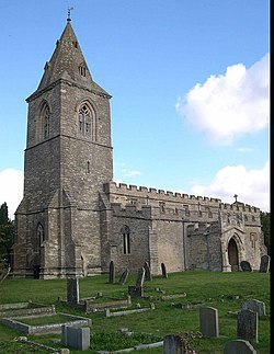
It is a good example of a village church mainly in the Decorated style. Originally the Trailly family received it from the monks at Thorney Abbey early in the 12th Century and was confirmed to them by a charter of Pope Alexander III in 1162. Although Norman in origin its shows no indication of this in its construction. It consists of a Nave and Chancel dating back to the early 13th Century and had been considerably re-modelled since then, the most notable feature being the tower and broach spire.

War (1939 – 1945)

Home Guard troops 'fighting' Valentine tanks of 6th Armoured Division during large-scale manoeuvres, 27 July 1941. Home Guard troops 'fighting' Valentine tanks of 6th Armoured Division during large-scale manoeuvres at Yelden in Bedfordshire, 27 July 1941. H12081.jpg
Home Guard troops 'fighting' Valentine tanks of 6th Armoured Division during large-scale manoeuvres, 27 July 1941.

World War II was a significant time in the history of the village because of its close proximity to Chelveston Aerodrome, which was originally built with three runways in 1941. An Airborne Forces Experimental Establishment detachment began flying from the aerodrome in 1942 with Horsa gliders towed by Short Stirling aircraft. Later in 1942, following the entry of the United States into the war, it eventually became the home of the United States Army Air Forces 305th Bombardment Group, which had four squadrons of Boeing B-17 Flying Fortresses pioneering the daylight formation and bombing procedures of the time. There were almost 2,000 personnel based at the aerodrome flying a total of 337 missions between November 1942 and April 1945. During these missions, a total of 22,362 tons of bombs were dropped on enemy targets and 332 enemy aircraft were claimed shot down at the expense of 154 Allied aircraft and 810 men.

During the aerodrome's construction, a series of buildings were erected in the village near the church as quarters for the Women's Auxiliary Air Force (WAAF) but instead became the sergeant's mess for the Americans. In more recent times these buildings, known locally as "the camps," fell into rack and ruin and so were demolished to make way for a new housing development. Today Philips Medows, Stanbrook Way and Forge Gardens stand on these sites.

Boeing B-17F-115-BO Flying Fortress Serial 42-30647 of the US Army Air Forces 366th Bombardment Squadron on a mission to Stuttgart, Germany, on 6 September 1943. On 23 September 1943, this aircraft crashed at Chevelston returning from a mission, killing all on board B-17g-305th-42-30647-chev.jpg
Boeing B-17F-115-BO Flying Fortress Serial 42-30647 of the US Army Air Forces 366th Bombardment Squadron on a mission to Stuttgart, Germany, on 6 September 1943. On 23 September 1943, this aircraft crashed at Chevelston returning from a mission, killing all on board

On 24 March 1944 [3] a Boeing B-17G Flying Fortress bomber belonging to the US Army Air Force's 422nd Bomb Squadron, 305th Bomb Group (Heavy), crashed on takeoff from RAF Chelveston, killing the entire crew of 10 and 11 persons on the ground. Today Forge Gardens stands on the crash site. [4] In May 2009 a service was held in the village church and a tablet recording the names of those who died in the crash was dedicated. Two children, Keith (aged 14) and Monica (aged 4), were killed during the crash when the aircraft hit the house they were sleeping in. The remainder of those who died consisted of servicemen who were sleeping in a barrack block which the aircraft hit and the crew of the bomber. It is said that at certain times of the year the distant drone of a B-17 can be heard in the early dawn hours, and there are also various sightings of ghostly airmen seen around the church yard and near to the crash site.

Notable figures

In June 1943, as Yielden had a depleted population, an American Air-force Pilot named Dick Rodgers assisted in the administration and running of the town's noted Strawberry Fayre. During his short stay there, Rodgers became a very popular figure within the community. He encouraged his fellow air-force pilots to volunteer and raise funds for the local church during their time at the Yielden airbase. He later died, whilst completing a supply drop during the Battle of the Bulge. Although his body was never recovered, there is a commemorative plaque on a bench outside the Western gate of the Church.

Joe Ekins (15 July 1923 – 1 February 2012), Tank Gunner, credited by some for killing German tank Commander Michael Wittmann was born in Yielden.

Name spelling

In common with most other place, the village name has evolved over the centuries. The earliest recorded version was 'Giveldene' in 1086 and since then there have been over 20 changes. At one stage (circa 1390) it was recorded as being 'Yelden' before becoming known as Yeveldene in 1461. Other names include Chivelden, Gyueldene, Yueldene, Yealdon, Evelden, Yeveldene, Yielding and Yeilden. Finally it was recorded as being 'Yelden' again in 1830 with the latest variant 'Yielden' having arrived in more recent times.

The "Yelden" spelling used on a signpost in Rushden UK Rushden.jpg
The "Yelden" spelling used on a signpost in Rushden

Depending on which direction you approach from you will find that the name of the village is spelt differently on various sign posts:

There has been much argument over the correct spelling the village name over recent years and it still remains a matter of confusion for those trying to find their way to the village. A questionnaire on the subject was circulated to villagers in 1998. 44 considered the village to be called 'Yelden' – 30 considered it to be called 'Yielden'. Different organisations take different positions on the spelling: the Royal Mail uses the spelling "Yielden" in official postal addresses, [5] whilst the parish council calls itself "Melchbourne and Yelden" parish council. [6] The Office for National Statistics records the official name of the parish to be "Melchbourne and Yielden", [7] whilst the Ordnance Survey labels the village itself "Yelden", but records the parish name as "Melchbourne and Yielden". [8]

Modern day

Social scene

Yelden is famed for its Strawberry Fayre which is held on the last Sunday in June each year. This generally attracts thousands of visitors to the village to sample oysters and champagne, strawberry teas, live jazz, classic cars, bikes and tractors and traditional summer fete activities to raise funds for the Church.

Village pub

The Chequers Inn closed in 2016. Whilst there have been attempts to reopen it tied with some development of land behind the pub, at time of writing (June 2021) the business remains closed.

Related Research Articles

<span class="mw-page-title-main">Walmer</span> Human settlement in England

Walmer is a town in the district of Dover, Kent, in England. Located on the coast, the parish of Walmer is six miles (9.7 km) south-east of Sandwich, Kent. Largely residential, its coastline and castle attract many visitors. It has a population of 6,693 (2001), increasing to 8,178 at the 2011 Census.

<span class="mw-page-title-main">Wing, Buckinghamshire</span> Village in Buckinghamshire, England

Wing, known in antiquated times as Wyng, is a village and civil parish in east Buckinghamshire, England. The village is on the main A418 road between Aylesbury and Leighton Buzzard. It is about 8 miles (13 km) north-east of Aylesbury, 3 miles (5 km) west of Leighton Buzzard, and 12 miles (19 km) south of Milton Keynes.

<span class="mw-page-title-main">Castle Bromwich</span> Human settlement in England

Castle Bromwich is a village and civil parish in the Metropolitan Borough of Solihull in the West Midlands, England. It borders the rest of the borough to the south east, Sutton Coldfield to the east and north east, Shard End to the south west, Castle Vale, Erdington and Minworth to the north and Hodge Hill to the west.

<span class="mw-page-title-main">Woodley, Berkshire</span> Town and civil parish in Berkshire, England

Woodley is a town and civil parish in the Borough of Wokingham, Berkshire, England, four miles (6.4 km) east of Reading and joined to the neighbouring town of Earley, two miles (3.2 km) to the west, and five miles (8 km) from Wokingham. Nearby are the villages of Sonning, Twyford, Winnersh, Hurst and Charvil.

<span class="mw-page-title-main">Pertenhall</span> Human settlement in England

Pertenhall is a small village and civil parish located in Bedfordshire, close to the borders of Cambridgeshire and Northamptonshire. Its parish council is a Quality Parish Council. It has recently published its Parish Plan which is available on the website

<span class="mw-page-title-main">Newton Bromswold</span> Human settlement in England

Newton Bromswold is a village and civil parish about 1.9 miles (3.1 km) east of Rushden in North Northamptonshire, England, adjacent to the border with Bedfordshire. At the 2001 census the parish's population was 62 people in 27 households. The population remained less than 100 at the 2011 Census and is included in the town of Rushden. It is near the villages of Wymington, Chelveston, Knotting, Knotting Green, Yelden and Melchbourne. There is a pub and a small church. The village takes its name from the forest which once stood where the village is today, called Bruneswald Forest.

<span class="mw-page-title-main">Ashingdon</span> Village and civil parish in Essex, England

Ashingdon is a village and civil parish in Essex, England. It is located about 2.5 miles (4 km) north of Rochford and is 13 miles (21 km) southeast from the county town of Chelmsford. The village lies within Rochford District and the parliamentary constituency of Rayleigh.

<span class="mw-page-title-main">RAF Chelveston</span> British Air Force station (1940–1962)

Royal Air Force Chelveston, or more simply RAF Chelveston, is a former Royal Air Force station located on the south side of the B645, 5 miles (8.0 km) east of Wellingborough, near the village of Chelveston in Northamptonshire, England. During the Second World War the airfield was occupied by both the Royal Air Force and the United States Army Air Forces. It was given the USAAF designation Station 105.

<span class="mw-page-title-main">Middleton, Norfolk</span> Human settlement in England

Middleton is a village and civil parish in the English county of Norfolk. It covers an area of 5.02 sq mi (13.0 km2) and had a population of 1,516 in 621 households at the 2001 census, reducing to 1,450 at the 2011 Census.

<span class="mw-page-title-main">Melchbourne and Yielden</span> Civil parish in Bedford, England

Melchbourne and Yielden is a civil parish in the Borough of Bedford in the county of Bedfordshire, England.

<span class="mw-page-title-main">Laughton en le Morthen</span> Village and civil parish in South Yorkshire, England

Laughton en le Morthen is a village and civil parish in the Metropolitan Borough of Rotherham lying to the south of Rotherham, South Yorkshire, England, and its main attraction is the All Saints Church with its tower and spire of 185 feet. The village had a population of 1,241 at the 2011 Census. The parish also includes the hamlets of Carr, Slade Hooton and Brookhouse.

Riseley is a village and civil parish located in North Bedfordshire, England. The village name has had alternative spellings in the past such as Rislau, Riseleg, Riselai and Risely, however all these spellings are considered archaic. It has a population of 1,284 according to the 2001 census, increasing to 1,286 at the 2011 Census, and is near the villages of Bletsoe, Sharnbrook, Swineshead, Pertenhall, Keysoe, Thurleigh and Melchbourne. The nearest town to Riseley is Rushden in the neighbouring county of Northamptonshire, approximately 8 miles away to the north west. The county town of Bedford is approximately 9 miles to the South of Riseley. The village has one watercourse, which is a tributary of the River Ouse, flowing through it known locally as the 'Brook' around which in medieval times the village was built.

<span class="mw-page-title-main">Pulford</span> Village in Cheshire, England

Pulford is a village and former civil parish, now in the parish of Poulton and Pulford, in the unitary authority of Cheshire West and Chester and the ceremonial county of Cheshire, England. It is on the B5445 road, to the south west of Chester and on the border with Wales. The civil parish, which included the hamlet of Cuckoo's Nest, was abolished in 2015 to form Poulton and Pulford.

<span class="mw-page-title-main">Yielden Castle</span>

Yielden Castle was a twelfth-century castle located in Yelden in the county of Bedfordshire, England.

<span class="mw-page-title-main">Knotting, Bedfordshire</span> Human settlement in England

Knotting is a village and former civil parish, now in the parish of Knotting and Souldrop, in the Bedford district, in the ceremonial county of Bedfordshire, located near the border with Northamptonshire. Nearby places are, Sharnbrook, Podington, Odell, Melchbourne, Yelden, Newton Bromswold, Souldrop and Rushden over the border in Northamptonshire. In 1931 the parish had a population of 114. On 1 April 1934 the parish was abolished to form "Knotting and Souldrop".

<span class="mw-page-title-main">Melchbourne</span> Human settlement in England

Melchbourne is a village and former civil parish, now in the parish of Melchbourne and Yielden, in the Bedford district, in the ceremonial county of Bedfordshire, England. In 1931 the parish had a population of 160. On 1 April 1934 the parish was abolished to form "Melchbourne and Yelden".

<span class="mw-page-title-main">RAF Harlaxton</span> Former Royal Air Force base in Lincolnshire, England

Royal Air Force Harlaxton or more simply RAF Harlaxton is a former Royal Air Force station near the village of Harlaxton, 3 mi (4.8 km) south west of Grantham, Lincolnshire, England. The airfield was located in a triangle of flat fields midway between Harlaxton Manor and the nearby village of Stroxton.

<span class="mw-page-title-main">Sywell Aviation Museum</span> Aviation museum in Sywell Aerodrome, Northamptonshire

Sywell Aviation Museum is based at Sywell Aerodrome in Northamptonshire, England. It is sited in the aircraft viewing car park at the aerodrome. It documents the history of flying in Northamptonshire from the early days to the present day with particular emphasis on the Second World War. The museum is run by the Sywell Aviation Museum Trust and is run by volunteers; it is closed during the winter months and reopens each Easter Saturday.

<span class="mw-page-title-main">Marske Aerodrome</span> Former military aerodrome in Marske, North Yorkshire, England

Marske Aerodrome was a First World War-era airfield used by the Royal Flying Corps, and later by the Royal Air Force, between 1917 and 1920. The aerodrome was just to the west of the village of Marske-by-the-Sea in Yorkshire, England. Marske aerodrome hosted air gunnery schools and trained pilots in tactics and methods of aerial combat so that they could be deployed to the front. Marske is known for being the aerodrome where W. E. Johns, author of the Biggles books, undertook his training, as well as being noted for some of the flying instructors who were famous among the aircrew cadre.

<span class="mw-page-title-main">Beverley Aerodrome</span> A former military First World War flying base in Yorkshire, England

Beverley Aerodrome, was a First World War era Royal Flying Corps training depot, in Bishop Burton, East Riding of Yorkshire, England. The site, like many others in Yorkshire, was developed from a racecourse on the western edge of Beverley, along the road between Beverley and York. Initially set up as a location for squadrons employed in Home Defence (HD), particularly preventing Zeppelin attacks on Hull and the east coast, the site later became a training depot for squadrons and flights who would then deploy to the front line. Beverley was also used as a standing up and transfer location for six Canadian Reserve Squadrons in 1917, all of which were posted to Canada. Beverley Aerodrome was used between 1916 and 1920, with the RAF later using the site in the 1930s in a non-flying role.

References

  1. "Population statistics Yelden AP/CP through time". A Vision of Britain through Time . Retrieved 31 January 2023.
  2. "Relationships and changes Yelden AP/CP through time". A Vision of Britain through Time. Retrieved 31 January 2023.
  3. Pages 136 – 138. Donald, William. 'John Burn One Zero Five: The Story of Chelveston Airfield and the 305th Bomb Group in Pictures. 2005. ( ISBN   1-90451-426-X)
  4. Crash Memorial – Church of St Mary, Yelden
  5. "Postcode Finder". Royal Mail. Retrieved 9 March 2022.
  6. "Melchbourne and Yelden Parish Council" . Retrieved 9 March 2022.
  7. "Open Geography Portal". Office for National Statistics. Retrieved 9 March 2022.
  8. Ordnance Survey 1:25,000 Map, 2021