
The Borough of Bedford is a unitary authority area with borough status in the ceremonial county of Bedfordshire, England. Its council is based in Bedford, its namesake and principal settlement, which is the county town of Bedfordshire. The borough contains one large urban area, the 71st largest in the United Kingdom that comprises Bedford and the adjacent town of Kempston, surrounded by a rural area with many villages. 75% of the borough's population live in the Bedford Urban Area and the five large villages which surround it, which makes up slightly less than 6% of the total land area of the Borough.
Clapham is a village and civil parish in the Borough of Bedford in Bedfordshire, England. It had a population of 3,643 as at the 2001 census, increasing to 4,560 at the 2011 Census.

Pertenhall is a small village and civil parish located in Bedfordshire, close to the borders of Cambridgeshire and Northamptonshire. Its parish council is a Quality Parish Council. It has recently published its Parish Plan which is available on the website

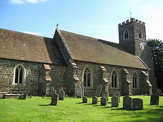
Millbrook is a small village and civil parish near Bedford, England. It has a population of 130, increasing to 147 at the 2011 Census. Millbrook railway station, on the Marston Vale Line, is about two miles (3 km) from the village. The parish church, dedicated to St Michael and All Angels, is Grade II* listed.
Biddenham is a village and civil parish in the Borough of Bedford in Bedfordshire, England, located around 2 miles (3.2 km) west of Bedford town centre near the A428 road. It forms part of the wider Bedford urban area.

Bletsoe is a village and civil parish in Bedfordshire, England. It is on the A6, and about eight miles north of Bedford. The village has a small park, the former site of Bletsoe Castle and a church. Nearby places are Sharnbrook, Milton Ernest, Riseley, Thurleigh, Odell, Souldrop, and Swineshead. The nearest town to Bletsoe is Bedford.
Bolnhurst is a small village and former civil parish, now in the parish of Bolnhurst and Keysoe, in the Borough of Bedford, Bedfordshire, England. The village is about 6 miles (9.7 km) north-northeast of Bedford town centre and about 6 miles (10 km) west of St Neots. In 1931 the parish had a population of 162.
Brogborough is a village and civil parish in the Central Bedfordshire district of Bedfordshire, England, by junction 13 of the M1 motorway. According to the 2001, census it had a population of 343, reducing to 302 at the 2011 Census. The village is about 2.5 miles (4 km) east of Milton Keynes in Buckinghamshire.

Moggerhanger is a village in the English county of Bedfordshire. It is west of Sandy on the road to Bedford. Its population in 2001 was 636, but had reduced to 620 at the 2011 Census. In the twentieth century the village name was spelled variously as: Moggerhanger, Mogerhanger, Muggerhanger and Morehanger. Local pronunciation of the name is as Morhanger.
Pulloxhill is a small village and civil parish in Bedfordshire, England 342 ft above sea level with a population of 850 at the 2001 Census, increasing to 985 at the 2011 Census.
Colmworth is a village and civil parish in the Borough of Bedford in the county of Bedfordshire, England about 6.5 miles (10 km) north-east of Bedford.
Riseley is a village and civil parish located in North Bedfordshire, England. The village name has had alternative spellings in the past such as Rislau, Riseleg, Riselai and Risely, however all these spellings are considered archaic. It has a population of 1,284 according to the 2001 census, increasing to 1,286 at the 2011 Census, and is near the villages of Bletsoe, Sharnbrook, Swineshead, Pertenhall, Keysoe, Thurleigh and Melchbourne. The nearest town to Riseley is Rushden in the neighbouring county of Northamptonshire, approximately 8 miles away to the north west. The county town of Bedford is approximately 9 miles to the South of Riseley. The village has one watercourse, which is a tributary of the River Ouse, flowing through it known locally as the 'Brook' around which in medieval times the village was built.

Husborne Crawley is a small village and civil parish in Bedfordshire, England, located close to Junction 13 of the M1 motorway. The village touches the borders of the Woburn Abbey estate on one side, and the village of Aspley Guise on the other. The meaning of the Husborne element of the towns name is "warrior stream" and the Crawley element means "crow clearing". It appears as Hussheburn Crawele, in 1421.
Little Houghton is a village and civil parish in Northamptonshire, England, located about 2 miles (3.2 km) east of Northampton. At the time of the 2001 census, the parish's population was 367 people, increasing to 412 at the 2011 census.
Great Houghton is a village near Northampton in West Northamptonshire. The population of the civil parish at the 2011 census was 642. It lies on the edge of the large market town, on the Bedford Road (A428). The village has two pubs and a large village hall and playing fields. The village was also the home of Great Houghton School - a private day school which closed in 2014.
Wilden is a village and civil parish located in the Borough of Bedford in Bedfordshire, England. The population of 399 in the 2011 Census was estimated at 392 in 2019.
Keysoe is a village and former civil parish, now in the parish of Bolnhurst and Keysoe, in the Bedford district, in the ceremonial county of Bedfordshire, England. In 1931 the parish had a population of 432. On 1 April 1934 the parish was abolished to form "Bolnhurst and Keysoe".

Keysoe Row is a hamlet located in the Borough of Bedford in Bedfordshire, England.

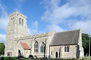
Thurleigh is a village and civil parish in the Borough of Bedford, north Bedfordshire, England, situated around 5 miles (8.0 km) north of Bedford town centre.

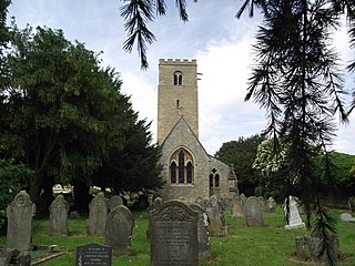
Little Staughton is a small village and civil parish located in the north of Bedfordshire. The parish church, All Saints, is set apart from the present village – the previous village having been abandoned following an outbreak of the Bubonic plague.
