Fair Isle, sometimes Fairisle, is the southernmost Shetland island, situated roughly 38 kilometres from the Shetland Mainland and about 43 kilometres from North Ronaldsay.
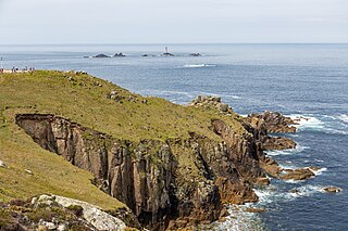
Land's End is a headland and tourist and holiday complex in western Cornwall, England, United Kingdom, on the Penwith peninsula about eight miles (13 km) west-south-west of Penzance at the western end of the A30 road. To the east of it is the English Channel, and to the west the Celtic Sea.

Suffolk is a ceremonial county in the East of England and East Anglia. It is bordered by Norfolk to the north, the North Sea to the east, Essex to the south, and Cambridgeshire to the west. Ipswich is the largest settlement and the county town.

East Anglia is an area in the East of England. It comprises the counties of Norfolk and Suffolk and Cambridgeshire, with Essex also included in some definitions. The name derives from the Anglo-Saxon kingdom of the East Angles, a people whose name originated in Anglia, in what is now Northern Germany.

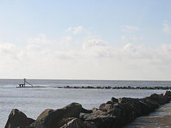
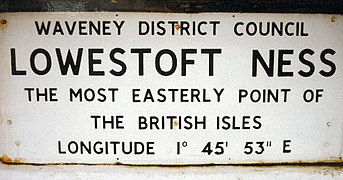
Lowestoft is a coastal town and civil parish in the East Suffolk district of Suffolk, England. As the most easterly UK settlement, it is 38 miles (61 km) north-east of Ipswich and 22 miles (35 km) south-east of Norwich, and the main town in its district. The estimated population in the built-up area exceeds 70,000. Its development grew with the fishing industry and as a seaside resort with wide sandy beaches. As fishing declined, oil and gas exploitation in the North Sea in the 1960s took over. While these too have declined, Lowestoft is becoming a regional centre of the renewable energy industry.
This is a list of the extreme points of the United Kingdom: the points that are farther north, south, east or west than any other location. Traditionally the extent of the island of Great Britain has stretched "from Land's End to John o' Groats".
Orford Ness is a cuspate foreland shingle spit on the Suffolk coast in Great Britain, linked to the mainland at Aldeburgh and stretching along the coast to Orford and down to North Weir Point, opposite Shingle Street. It is divided from the mainland by the River Alde, and was formed by longshore drift along the coast. The material of the spit comes from places further north, such as Dunwich. Near the middle point of its length, at the foreland point or 'Ness', once stood Orfordness Lighthouse, demolished in summer 2020 owing to the encroaching sea. In the name of the lighthouse, 'Orfordness' is written as one word.
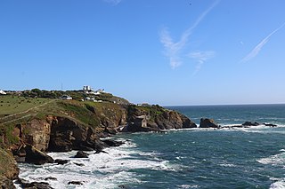
Lizard Point in Cornwall is at the southern tip of the Lizard Peninsula. It is situated half-a-mile (800 m) south of Lizard village in the civil parish of Landewednack and about 11 miles (18 km) southeast of Helston.

Carlton Colville is a seaside town and civil parish in the English county of Suffolk. It is 3 miles (5 km) south-west of the centre of the town of Lowestoft in the East Suffolk district. The area lies along the A146 Lowestoft to Beccles road.

Corton is a village and civil parish in the north of the English county of Suffolk. It is 3 miles (4.8 km) north of the centre of Lowestoft in the East Suffolk district. The village is on the North Sea coast with the county border with Norfolk to the north.

This is a list of the extreme points of the British Isles, the points that are farther north, south, east, west, higher or lower than any other location.

Lound is a village and civil parish in the north of the English county of Suffolk. It is 4.5 miles (7.2 km) north of Lowestoft, 5 miles (8.0 km) south of Great Yarmouth in the East Suffolk district. It is 2 miles (3.2 km) from the North Sea coast at Hopton-on-Sea and is on the border with the county of Norfolk.

Loch Ness is a large freshwater loch in the Scottish Highlands extending for approximately 37 kilometres southwest of Inverness. It takes its name from the River Ness, which flows from the northern end. Loch Ness is best known for claimed sightings of the cryptozoological Loch Ness Monster, also known affectionately as "Nessie". It is one of a series of interconnected, murky bodies of water in Scotland; its water visibility is exceptionally low due to the high peat content of the surrounding soil. The southern end connects to Loch Oich by the River Oich and a section of the Caledonian Canal. The northern end connects to Loch Dochfour via the River Ness, which then ultimately leads to the North Sea via the Moray Firth.

Pakefield is a suburb of the town of Lowestoft, in the East Suffolk district, in the north of the English county of Suffolk. It is located around 2 miles (3.2 km) south of the centre of the town. It 2011 the ward had a population of 6,563.

Suffolk Fire and Rescue Service (SFRS) is the statutory fire and rescue service covering the county of Suffolk in East Anglia, England. It was formed in 1948 as the Suffolk & Ipswich Fire Service, before changing after the 1974 Local Government Review to 'Suffolk Fire Service'. Following the 2004 Fire & Rescue Services Act, the service name was changed to Suffolk Fire & Rescue Service to better reflect its role. Suffolk has a population of 760,556 and covers 1,466 square miles (3,800 km2). The county town is Ipswich with other major towns including Lowestoft, Bury St-Edmunds, Felixstowe and Newmarket.

The Port of Lowestoft is a harbour and commercial port in Lowestoft in the English county of Suffolk owned by Associated British Ports. It is the most easterly harbour in the United Kingdom and has direct sea access to the North Sea. The harbour is made up of two sections divided by a bascule bridge. The inner harbour is formed by Lake Lothing whilst the outer harbour is constructed from breakwaters. Lowestoft handles around 30,000 tonnes of cargo per year.

North Cove is a village and civil parish in the north of the English county of Suffolk. It is part of the East Suffolk district, located around 3 miles (4.8 km) east of Beccles and 5 miles (8.0 km) west of Lowestoft. It merges with the village of Barnby and the villages share some resources, although the two parishes retain separate parish councils.
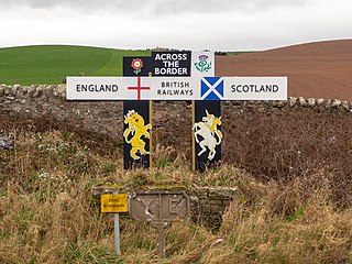
Marshall Meadows Bay is the northernmost point of England. It is located on the Northumberland coast, 2+1⁄2 miles north of Berwick-upon-Tweed, and just to the south of the Anglo-Scottish border. Across the border in Scotland is the county of Berwickshire in the Borders region. The hamlet of Marshall Meadows lies to the west of the bay, and is the most northerly inhabited place in England. The Marshall Meadows Manor House Hotel is here, along with a farm and a caravan site. There is a disused tunnel from the caravan site to the bay below, and there is a small cave 300 m (1,000 ft) north of this tunnel, plus another small cave just around the corner of Marshall Meadows Point. Nearby is the A1 trunk road and the East Coast Main Line railway.
East Suffolk is a local government district in Suffolk, England. The largest town is Lowestoft, which contains Ness Point, the easternmost point of the United Kingdom. The second largest town is Felixstowe, which has the country's largest container port. On the district's south-western edge it includes parts of the Ipswich built-up area. The rest of the district is largely rural, containing many towns and villages, including several seaside resorts. Its council is based in the village of Melton. The district was formed in 2019 as a merger of the two previous districts of Suffolk Coastal and Waveney. In 2021 it had a population of 246,058. It is the most populous district in the country not to be a unitary authority.