
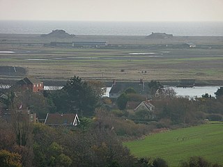
Aldeburgh is a North Sea coastal English town in the county of Suffolk, north of the River Alde. Its estimated population was 2,276 in 2019. It was home to the composer Benjamin Britten and has been the centre of the international Aldeburgh Festival of arts at nearby Snape Maltings, founded by Britten in 1948. It remains an arts and literary centre, with an annual poetry festival and several food festivals and other events. As a Tudor port, Aldeburgh gained borough status in 1529 under Henry VIII. Its historic buildings include a 16th-century moot hall and a Napoleonic-era Martello Tower. Second homes make up about a third of its housing. Visitors are drawn to its Blue Flag shingle beach and fisherman huts, where fresh fish are sold daily, by Aldeburgh Yacht Club, and by its cultural offerings. Two family-run fish and chip shops are listed among the best in the country.

The Suffolk Coast and Heaths AONB is an Area of Outstanding Natural Beauty in Suffolk, England.

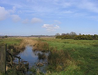
RSPB Minsmere is a nature reserve owned and managed by the Royal Society for the Protection of Birds (RSPB) at Minsmere, Suffolk. The 1,000-hectare (2,500-acre) site has been managed by the RSPB since 1947 and covers areas of reed bed, lowland heath, acid grassland, wet grassland, woodland and shingle vegetation. It lies within the Suffolk Coast and Heaths Area of Outstanding Natural Beauty and the Suffolk Heritage Coast area. It is conserved as a Site of Special Scientific Interest, Special Area of Conservation, Special Protection Area and Ramsar site.

Suffolk Wildlife Trust (SWT) describes itself as the county's "nature charity – the only organisation dedicated wholly to safeguarding Suffolk's wildlife and countryside." It is a registered charity, and its headquarters is at Brooke House in Ashbocking, near Ipswich. It was founded in 1961, and is one of 46 wildlife trusts covering the Great Britain and Northern Ireland. As of March 2017, it has 13,200 members, and it manages 3,120 hectares of land in 60 nature reserves, most of which are open to the public. It had an income of £3.9 million in the year to 31 March 2017.
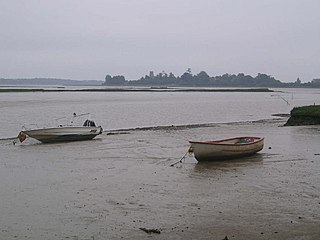
Orford Ness is a cuspate foreland shingle spit on the Suffolk coast in Great Britain, linked to the mainland at Aldeburgh and stretching along the coast to Orford and down to North Weir Point, opposite Shingle Street. It is divided from the mainland by the River Alde, and was formed by longshore drift along the coast. The material of the spit comes from places further north, such as Dunwich. Near the middle point of its length, at the foreland point or 'Ness', once stood Orfordness Lighthouse, demolished in summer 2020 due to the encroaching sea. In the name of the lighthouse, 'Orfordness' is written as one word.
Minsmere is a place in the English county of Suffolk. It is located on the North Sea coast around 3.5 miles (5.6 km) north of Leiston and 1.5 miles (2.4 km) south-east of Westleton within the Suffolk Coast and Heaths AONB. It is the site of the Minsmere RSPB reserve and the original site of Leiston Abbey.

Orford is a village with historic town status in Suffolk, England, within the Suffolk Coast and Heaths AONB. It is located 9 miles (14 km) east of Woodbridge.

The River Alde and River Ore form a river system in Suffolk, England passing by Snape and Aldeburgh. The River Alde and River Ore meet northwest of Blaxhall. From there downriver the combined river is known as the River Alde past Snape and Aldeburgh, and then again as the River Ore as it approaches Orford and flows by a shingle spit before emptying into the North Sea.

Boyton is a village and civil parish in the East Suffolk district of Suffolk, England, about eight miles east of Woodbridge, and close to Orford Ness. Boyton is a small village in South East England and is part of the heritage coast. In the Domesday Book of 1086 Boyton was recorded under the name "Bohtuna". The village has a number of facilities within the surrounding area, for instance Hollesley primary school, a village primary school for children aged 4–11 years. Boyton village hall is becoming a focus for new village activities, and HM Prison Hollesley Bay is also located not far from the village centre. In the 1870s Boyton was described by John Marius Wilson as:

The River Deben is a river in Suffolk rising to the west of Debenham, though a second, higher source runs south from the parish of Bedingfield. The river passes through Woodbridge, turning into a tidal estuary before entering the North Sea at Felixstowe Ferry. The mouth of the estuary is crossed by a ferry connecting Felixstowe and Bawdsey.

Havergate Island is the only island in the county of Suffolk, England. It is found at the confluence of the River Ore and the Butley River near the village of Orford. It is a marshy nature reserve run by the Royal Society for the Protection of Birds (RSPB) and is known for its population of avocets and terns. It is part of the ecologically important Alde-Ore Estuary and has protected conservation status as part of a national nature reserve, SSSI, SAC, SPA, Ramsar Site and is also a part of the Suffolk Coast and Heaths AONB.
Regional Cycle Route 41 in Suffolk runs from Snape to Bramfield through the Suffolk Coast and Heaths, an Area of Outstanding Natural Beauty.
The ferries in Suffolk are a series of local ferry services in the county of Suffolk in Eastern England. Most cross rivers within the county, although some connect Suffolk with Essex to the south.
Plomesgate is a hundred of Suffolk, consisting of 41,579 acres (168.26 km2).

Alde–Ore Estuary is a 2,534 hectare biological and geological Site of Special Scientific Interest which stretches along the Suffolk coast between Aldeburgh and Bawdsey, and also includes parts of the Alde, Ore and Butley Rivers. It is in the Suffolk Coast and Heaths Area of Outstanding Natural Beauty, and is a Grade I Nature Conservation Review site, a Special Area of Conservation, a Ramsar internationally important wetland site, and a Special Protection Area under the European Union Directive on the Conservation of Wild Birds. It includes two Geological Conservation Review sites, "Orfordness and Shingle Street" and "The Cliff, Gedgrave", and two nature reserves managed by the Suffolk Wildlife Trust, Alde Mudflats and Simpson's Saltings. The coastal part of the site is Orfordness-Havergate, a National Nature Reserve, and Orford Ness is managed by the National Trust, while Havergate Island is managed by the Royal Society for the Protection of Birds.

Capel St Andrew is a village and a civil parish in the East Suffolk district, in the county of Suffolk, England. It is near the larger settlement of Orford.
Alde Mudflats is a 22 hectare nature reserve west of Iken in Suffolk. It is owned by the Crown Estate and managed by the Suffolk Wildlife Trust. It is in the Suffolk Coast and Heaths Area of Outstanding Natural Beauty, and part of the Alde-Ore Estuary Site of Special Scientific Interest, Ramsar internationally important wetland site, Special Area of Conservation, Special Protection Area under the European Union Directive on the Conservation of Wild Birds, and Grade I Nature Conservation Review site,

Simpson's Saltings is a 25 hectare nature reserve on the Suffolk coast east of Hollesley. It is managed by the Suffolk Wildlife Trust. It is in the Suffolk Coast and Heaths Area of Outstanding Natural Beauty, and part of the Alde-Ore Estuary Site of Special Scientific Interest, Ramsar internationally important wetland site, Special Area of Conservation, Special Protection Area under the European Union Directive on the Conservation of Wild Birds, and Grade I Nature Conservation Review site,

Minsmere River is a river in the English county of Suffolk which flows into the North Sea at Minsmere. The river is formed from the River Yox at Yoxford before flowing through Middleton, Eastbridge and Minsmere. It flows to the south of Minsmere RSPB reserve helping to form many of the wetland habitats at the reserve.

