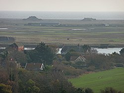
Orford Ness | |
---|---|
Near Orford, Suffolk | |
Coordinates | 52°04′53″N01°33′31″E / 52.08139°N 1.55861°E |
Type | National Nature Reserve, Site of Special Scientific Interest, internationally important site for nature conservation, former military test site |
Site information | |
Operator | Ministry of Defence, Atomic Weapons Research Establishment, National Trust for Places of Historic Interest or Natural Beauty |
Status | Inactive |
Site history | |
In use | 1913 – early 1983 |
Orford Ness is a cuspate foreland shingle spit on the Suffolk coast in Great Britain, linked to the mainland at Aldeburgh and stretching along the coast to Orford and down to North Weir Point, opposite Shingle Street. It is divided from the mainland by the River Alde, and was formed by longshore drift along the coast. The material of the spit comes from places further north, such as Dunwich. Near the middle point of its length, at the foreland point or 'Ness', once stood Orfordness Lighthouse, [1] demolished in summer 2020 owing to the encroaching sea. [2] In the name of the lighthouse (and the radio transmitting station – see below), 'Orfordness' is written as one word.
Orford Ness is an internationally important site for nature conservation. It contains a significant portion of the European reserve of vegetated shingle habitat, [3] which is internationally scarce, highly fragile, and very easily damaged. Together with Havergate Island the site is a designated National Nature Reserve [4] and forms part of: the Alde-Ore Estuary Site of Special Scientific Interest (SSSI); [5] the Alde, Ore & Butley Estuaries [6] and the Orfordness-Shingle Street [7] Special Area of Conservation (SAC); the Alde-Ore Estuary Special Protection Area (SPA); [8] the Alde-Ore Estuary Ramsar Site site; [9] the Suffolk Coasts and Heaths Area of Outstanding Natural Beauty (AONB); [10] and the Suffolk Heritage Coast. [11] It is also listed as of national importance in the Geological Conservation Review (GC), [12] as a grade 1 site in the Nature Conservation Review. [13] (NCR) and qualifies for the DEFRA Environmentally Sensitive Area (ESA) scheme. [14]
The peninsula was formerly administered by the Ministry of Defence, which conducted secret military tests during both world wars and the Cold War. The site was selected as the location for the Orfordness Beacon, one of the earliest experiments in long-range radio navigation. The Beacon was set up in 1929 and used in the pre-war era. In the 1930s Orford Ness was the site of the first purpose-built experiments on the defence system that would later be known as radar. Having proved the technology on Orford Ness, Robert Watson-Watt and his team moved to nearby Bawdsey Manor and developed the Chain Home radar system in time for its vital role in the Battle of Britain. [15]
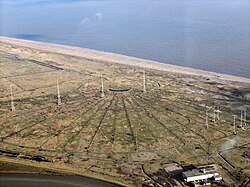
The Atomic Weapons Research Establishment had a base on the site, used for environmental testing, i.e. testing conducted to determine the functional performance of a component or system under conditions that simulate the real environment in which the component or system is expected to operate. Many of the buildings from this time remain clearly visible from the quay at Orford, including the distinctive 'pagodas'. [16]
In the late 1960s an experimental Anglo-American military over-the-horizon radar known as Cobra Mist was built on the peninsula. It closed in 1973, and in the late 1970s and early 1980s the site and building were re-used for the Orfordness transmitting station. This powerful medium-wave radio station – originally owned and run by the Foreign Office, then the BBC and, after privatisation in the 1990s, a series of private companies – was best known for transmitting the BBC World Service in English around the clock to continental Europe on 648 kHz from September 1982 until March 2011. The following year, the site became disused until Radio Caroline began broadcasting from it in December 2017. [18] [19]
Orford Ness is now owned by the National Trust and is open to the public under the name Orford Ness National Nature Reserve, though access is strictly controlled to protect the fragile habitats and due to a residual danger to the public from the site's former use by the military. Access is available only by the National Trust ferry from Orford Quay on designated open days. [20] Urban explorers have also visited the site. [21]
Rachel Woodward writes:
It is a place of strange contrasts. For the National Trust, its 'elemental nature' contrasts with the 'inherent dangers' of this place, a 'hostile and potentially dangerous site'. Military structures – the Bomb Ballistics Building, the Black Beacon, the 'pagodas' used for explosive design – have been converted into viewing spots. This is not a celebratory site, however; there is ambivalence and doubt here, with regard to what is being physically and ideologically conserved. [22] [lower-alpha 1]
Owing to its military history, its stark appearance and the fact that it was closed to the public for many decades, several apocryphal stories have circulated about Orford Ness. The best-known is the suggestion that Nazi troops attempted to invade England and actually disembarked at the tip of the peninsula near Shingle Street, before being repelled with a wall of fire. Official sources denied that any such attempted invasion took place, an assertion confirmed by classified documents released in 1993. More recently, the flashes of the lighthouse were implicated in the Rendlesham Forest UFO sightings of late December 1980. In 2013, Trinity House announced that the lighthouse was to be decommissioned as an aid to navigation and marked on UKHO charts as disused. [23] It was demolished in summer 2020. [2]
In September 2023, the National Trust employed contractor Bam (working with Historic England and University College London's Bartlett School for Sustainable Construction) to survey the site - in particular, the AWRE Labs 4 and 5, or pagodas - using drones and a dog-like robot named Spot, manufactured by US firm Boston Dynamics. Concrete decay meant the buildings could not be safely surveyed by human surveyors. National Trust archaeologist Angus Wainwright said the team wanted "to see if it's possible to do a really detailed building survey with no human operator in the building." [24]
Orford Ness is Europe's largest vegetated shingle spit. [25] [lower-alpha 2] It is approximately 10 miles (16 km) long, [26] and the site covers a total area of approximately 2,230 acres (900 ha). [27] Forty percent of this (890 acres) is shingle, 25 percent (556 acres) tidal rivers, mud flats, sand flats, and lagoons, eighteen percent (400 acres) grassland, and fifteen percent (330 acres) salt marsh. [27]
The spit formed almost entirely of flint deposited by waves through the process of long-shore drift. The main influence on its formation has been storm waves throwing shingle over the top of the beach crest, where it is protected from ordinary wave action. [25] Over time, this process leads to the formation of stable ridges of fine particles, and swails of coarser shingle. [25]
The size and shape of the spit fluctuate over time (see map). Estimated growth rates range from 64 m per year in 1962 to 1967, to 183 m per year in 1804 to 1812. Between 1812 and 1821, the total length fluctuated by 1.8 miles (2.9 km). [28] As a result of the dynamically changing nature of the spit, the true age of its formation is unknown. [29] However, before about 1200, Orford is thought to have been a port facing the open sea. [30]
Aldeburgh is a coastal town in the county of Suffolk, England, north of the River Alde. Its estimated population was 2,276 in 2019. It was home to the composer Benjamin Britten and remains the centre of the international Aldeburgh Festival of arts at nearby Snape Maltings, which was founded by Britten in 1948. It also hosts an annual poetry festival and several food festivals and other events.
The Suffolk Coast and Heaths AONB is an Area of Outstanding Natural Beauty in Suffolk and Essex, England.
Spurn is a narrow sand tidal island located off the tip of the coast of the East Riding of Yorkshire, England that reaches into the North Sea and forms the north bank of the mouth of the Humber Estuary. It was a spit with a semi-permanent connection to the mainland, but a storm in 2013 made the road down to the end of Spurn impassable to vehicles at high tide.
Suffolk Wildlife Trust (SWT) describes itself as the county's "nature charity – the only organisation dedicated wholly to safeguarding Suffolk's wildlife and countryside." It is a registered charity, and its headquarters is at Brooke House in Ashbocking, near Ipswich. It was founded in 1961, and is one of 46 wildlife trusts covering the Great Britain and Northern Ireland. As of March 2017, it has 13,200 members, and it manages 3,120 hectares of land in 60 nature reserves, most of which are open to the public. It had an income of £3.9 million in the year to 31 March 2017.
Orford is a village in Suffolk, England, within the Suffolk Coast and Heaths Area of Outstanding Natural Beauty. It is 9 miles (14 km) east of Woodbridge.
The River Alde and River Ore form a river system in Suffolk, England passing by Snape and Aldeburgh. The River Alde and River Ore meet northwest of Blaxhall. From there downriver the combined river is known as the River Alde past Snape and Aldeburgh, and then again as the River Ore as it approaches Orford and flows by a shingle spit before emptying into the North Sea.
Havergate Island is the only island in the county of Suffolk, England. It is found at the confluence of the River Ore and the Butley River near the village of Orford. It is a marshy nature reserve run by the Royal Society for the Protection of Birds (RSPB) and is known for its population of pied avocets and terns. It is part of the ecologically important Alde-Ore Estuary and has protected conservation status as part of a national nature reserve, SSSI, SAC, SPA, Ramsar Site and is also a part of the Suffolk Coast and Heaths AONB.
Colne Estuary is a 2915 hectare biological and geological Site of Special Scientific Interest near Brightlingsea in Essex. It is also a Nature Conservation Review site, a National Nature Reserve, a Ramsar wetland site of international importance, a Special Protection Area, a Special Area of Conservation, and a Geological Conservation Review site. Three areas in the site are managed by the Essex Wildlife Trust, Colne Point, Fingringhoe Wick and Howlands Marsh.
The Butley River or Butley Creek is a tributary of the River Ore in the English county of Suffolk. The river has its source in the Rendlesham Forest area to the east of Eyke.
Alde–Ore Estuary is a 2,534 hectare biological and geological Site of Special Scientific Interest which stretches along the Suffolk coast between Aldeburgh and Bawdsey, and also includes parts of the Alde, Ore and Butley Rivers. It is in the Suffolk Coast and Heaths Area of Outstanding Natural Beauty, and is a Grade I Nature Conservation Review site, a Special Area of Conservation, a Ramsar internationally important wetland site, and a Special Protection Area under the European Union Directive on the Conservation of Wild Birds. It includes two Geological Conservation Review sites, "Orfordness and Shingle Street" and "The Cliff, Gedgrave", and two nature reserves managed by the Suffolk Wildlife Trust, Alde Mudflats and Simpson's Saltings. The coastal part of the site is Orfordness-Havergate, a National Nature Reserve, and Orford Ness is managed by the National Trust, while Havergate Island is managed by the Royal Society for the Protection of Birds.
Alde Mudflats is a 22 hectare nature reserve west of Iken in Suffolk. It is owned by the Crown Estate and managed by the Suffolk Wildlife Trust. It is in the Suffolk Coast and Heaths Area of Outstanding Natural Beauty, and part of the Alde-Ore Estuary Site of Special Scientific Interest, Ramsar internationally important wetland site, Special Area of Conservation, Special Protection Area under the European Union Directive on the Conservation of Wild Birds, and Grade I Nature Conservation Review site,
Dingle Marshes is a 93-hectare (230-acre) wildlife reserve on the North Sea coast of the English county of Suffolk. The reserve is located between Dunwich and Walberswick, approximately 4 miles (6.4 km) south-west of Southwold. The marshes make up part of the Suffolk Coast National Nature Reserve along with reserves at Walberswick and Hen Reedbeds. They are owned jointly by the RSPB and Suffolk Wildlife Trust and are managed by these two organisations and Natural England. The site is in the Dunwich Heaths and Marshes Nature Conservation Review site, Grade I, the Minsmere-Walberswick Ramsar internationally important wetland site, the Minsmere to Walberswick Heaths and Marshes Special Area of Conservation, and the Minsmere-Walberswick Special Protection Area under the European Union Directive on the Conservation of Wild Birds.
Simpson's Saltings is a 25 hectare nature reserve on the Suffolk coast east of Hollesley. It is managed by the Suffolk Wildlife Trust. It is in the Suffolk Coast and Heaths Area of Outstanding Natural Beauty, and part of the Alde-Ore Estuary Site of Special Scientific Interest, Ramsar internationally important wetland site, Special Area of Conservation, Special Protection Area under the European Union Directive on the Conservation of Wild Birds, and Grade I Nature Conservation Review site,
Hazlewood Marshes is a 64 hectare nature reserve west of Aldeburgh in Suffolk. It is managed by the Suffolk Wildlife Trust. It is in the Alde-Ore Estuary biological Site of Special Scientific Interest.
Minsmere–Walberswick Heaths and Marshes are a Special Area of Conservation and Site of Special Scientific Interest in the English county of Suffolk. The site is located on the North Sea coast between Southwold and Sizewell, extending over an area of coastline around 7 miles (11 km) in length. The site is also designated as a Special Protection Area, part of the Minsmere–Walberswick European Marine Site and contains areas designated as Ramsar sites and Natura 2000 sites. It lies within the Suffolk Coast and Heaths Area of Outstanding Natural Beauty and is made up of a "complex mosaic" of marshes, reed beds, shingle banks and lowland heath habitats.
Stour Estuary is a 2,523 hectare biological and geological Site of Special Scientific Interest which stretches from Manningtree to Harwich in Essex and Suffolk. It is also an internationally important wetland Ramsar site, a Special Protection Area and a Nature Conservation Review site. It is part of the Suffolk Coast and Heaths Area of Outstanding Natural Beauty, and there are Geological Conservation Review sites in Wrabness, Stutton, and Harwich Part of the site is managed by the Royal Society for the Protection of Birds, and a small area is Wrabness Nature Reserve, a Local Nature Reserve managed by the Essex Wildlife Trust.
Pakefield to Easton Bavents is a 735.4-hectare (1,817-acre) biological and geological Site of Special Scientific Interest which stretches along the Suffolk coast between Lowestoft and Southwold. It includes three Geological Conservation Review sites, and part of the Benacre National Nature Reserve. An area of 326.7 hectares is the Benacre to Easton Bavents Lagoons Special Area of Conservation, and 470.6 hectares is the Benacre to Easton Bavents Special Protection Area under the European Union Directive on the Conservation of Wild Birds. The site is also partly in the Suffolk Coast and Heaths Area of Outstanding Natural Beauty.
Hurst Castle and Lymington River Estuary is a 1,077.3-hectare (2,662-acre) biological and geological Site of Special Scientific Interest near Lymington in Hampshire. It is a Nature Conservation Review site and two areas are Geological Conservation Review sites. Three areas are local nature reserves, Boldre Foreshore, Sturt Pond and Lymington and Keyhaven Marshes; the latter site is managed by the Hampshire and Isle of Wight Wildlife Trust. Part of it is North Solent National Nature Reserve. It is part of Solent and Southampton Water Ramsar site and Special Protection Area. Parts of it are in Solent Maritime and Solent and Isle of Wight Lagoons Special Areas of Conservation.
Lee-on-The Solent to Itchen Estuary is a 585.9-hectare (1,448-acre) biological and geological Site of Special Scientific Interest which stretches along the coast between Southampton and Gosport in Hampshire. It is a Geological Conservation Review site. It is part of Solent and Southampton Water Ramsar site and Special Protection Area, and of Solent Maritime Special Area of Conservation. Three areas are Local Nature Reserves, Chessel Bay, Hook with Warsash and Mercury Marshes. One area is Hamble Common Camp, a Scheduled Monument.