Cobra Mist

Last updated

The former Cobra Mist building in October 2004 Harumphy.cobramist.jpg
The former Cobra Mist building in October 2004
Invisible Square.svg
Mapscaleline.svg
2km
1.2miles
Red pog.svg
N
O
R
T
H
S
E
A
Red pog.svg
Jetty
Red pog.svg
Red pog.svg
'Pagodas'
Orford Ness
National Nature
Reserve
Invisible Square.svg
Red pog.svg
Orfordness Beacon
Invisible Square.svg
Red pog.svg
transmitting
station
Invisible Square.svg
Red pog.svg
Havergate
Island (RSPB)
Invisible Square.svg
Red pog.svg
Cobra Mist
Invisible Square.svg
R i v e r   A l d e
Invisible Square.svg
R i v e r   O r e
Invisible Square.svg
Red pog.svg
Lighthouse
Invisible Square.svg
Red pog.svg
Castle
Invisible Square.svg
Cobra Mist
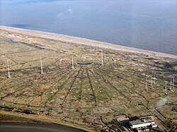
Orford Ness, Suffolk, showing locations of main sites. [1]

Cobra Mist was the codename for an Anglo-American experimental over-the-horizon radar station at Orford Ness, England [lower-alpha 1] . It was known technically as AN/FPS-95 and sometimes referred to as System 441a; a reference to the project as a whole.

Contents

Cobra Mist was part of a small number of "Cobra" long-range surveillance radars operated by the US. Cobra Mist was originally intended to be mounted in Turkey and to offer coverage of most of European Soviet airspace. When Turkey objected to the installation, it was moved to the UK and sited to offer a view of most of Eastern Europe. Built through the late 1960s and into 1970, when the system was first turned on it proved to be plagued by noise problems that could not be identified, and the project was shut down in 1973.

The site and buildings were then occupied by a radio transmitting station used mainly for the UK Foreign Office and the BBC World Service until 2011. In August 2015, the site and all the facilities previously held by the UK Foreign Office and the BBC (and prior to them the Ministry of Defence) were acquired by Cobra Mist Limited, a privately owned company. The main building and 12 towers remain. Five are 340 feet high.

Classification of radar systems

Under the Joint Electronics Type Designation System (JETDS), all U.S. military radar and tracking systems are assigned a unique identifying alphanumeric designation. The letters “AN” (for Army-Navy) are placed ahead of a three-letter code. [2]

Thus, the AN/FPS-95 represents the 95th design of an Army-Navy “Fixed, Radar, Search” electronic device. [2] [3]

History

Background

Cobra Mist was based on the Naval Research Laboratory's experimental Magnetic-Drum Radar Equipment ('MADRE'), which was able to reliably detect aircraft at ranges up to 2,000 nautical miles (3,700 km) from its base on the Chesapeake Bay. With prior setup, MADRE was even able to detect rocket launches at Cape Canaveral and atomic tests in Nevada. [4] [lower-alpha 2]

With this successful demonstration, the US Air Force started plans to deploy a similar system in Turkey; providing coverage of much of the western part of the Soviet Union. Tenders for the system outline were placed in 1964 and bids followed the next year for the actual system itself. However, Turkey refused to provide a base for the system and a search started for a new location. [5]

After some time the British offered a site in Suffolk. From this location the radar would be able to see almost all of Eastern Europe as well as the western parts of the Soviet Union. In particular, it would be able to track missile launches from the Northern Fleet Missile Test Center at Plesetsk. Although not as useful as the original site in Turkey, the UK site was nevertheless acceptable and the USAF accepted the new location. [4]

Construction

In 1966, a new series of bids was sent out for a system to be installed at this site, which was won late in the year by RCA. Construction of the site started in mid-1967 with the buildings and support systems which had to be carefully shielded to avoid contamination from signals being reflected locally. Many of the buildings had to be built on short stilts because the site was below the maximum water height recorded some years earlier. [6]

The site was completed on 10 July 1971 and testing began a week later. Tests of the broadcast system were extensive, including both local measurements as well as tests from distant aircraft. These were completed by September and attention moved to the reception systems. Minor storm damage in October slowed this phase somewhat, but RCA turned the system over to the USAF in February 1972. The original plan to go operational in July was delayed until January 1973, in spite of a truncated testing period that combined the "Design Verification System Test" and "Initial Operational Test and Evaluation" periods. [6]

Problems and closure

Through the early part of 1972 testing found a considerable amount of unexpected noise, which appeared as frequency shifting of the signal. This made targets appear in all of the filters (high-speed, low-speed, etc.) even when it seemed there was nothing of the sort in that area. For instance, the system would often report missiles being launched no matter where the radar was looking. A lengthy series of investigations into the source of the noise followed and, in desperation, the USAF eventually turned over the testing to a panel headed by SRI International. The new team continued testing from January to May 1973, but no convincing explanation was ever found. Internal problems with the equipment were eliminated as a potential source. One particularly interesting finding was that the distortion only occurred over land. Deliberate electronic countermeasures were not ruled out. [6]

Although the noise was never identified, the panel concluded that the system could still be made operational by further improvements in the receivers; although the resulting system would only be marginally useful. Instead the USAF simply gave up and on 30 June 1973 the system was shut down, never having been used operationally. It is estimated to have cost between $100 and $150 million (equivalent to $1030 million in 2023). [6]

As part of the ABM Treaty, large long-range radars were limited to operation in the home countries of the operators. Whether this had an effect on Cobra Mist is unknown. [7]

Description

Radiating lines at the site Orfordness transmitting station.jpg
Radiating lines at the site

The AN/FPS-95 antenna consisted of 18 individual strings radiating outward from a single point near the eastern shore of Orford Ness. Each string was 2,040 feet (620 m) long, supported on masts from 42 feet (13 m) to 195 feet (59 m) high, with multiple active elements hung from the strings. The strings were arranged 8 degrees 40 minutes apart, covering an arc from 19.5 to 110.5 degrees clockwise from true north. Beneath the antenna was a large wire mesh screen acting as a reflector. The mesh extended past the hub to the east. [8]

Operating the AN/FPS-95 radar took considerable pre-observation setup. To select a particular region of the sky, six adjacent antennas strings were connected to the electronics using a switch matrix hidden underground at the antenna hub. Using beam steering, the operators would select a 90 degree wide fan-shaped area to investigate. The minimum range was about 500 nmi (930 km) due to the maximum elevation of the beams, while the maximum range was about 2,000 nmi (3,700 km) using one-hop off the ionosphere's F-layer. Ranges between this could be selected by changing the broadcast frequency from 6 to 40 MHz and gated by varying the pulse repetition frequency. Longer ranges were possible under certain conditions by allowing for multi-hop propagation. At high frequencies the active portion would be close to the antenna hub and it would move out toward the larger dipole elements as the frequency was lowered. [7]

The antenna was not particularly effective, with a gain of about 25 db, so to receive a useful signal from such ranges an enormous broadcast signal was needed. The system could develop a peak power of up to 10 MW, which can be compared to the most powerful commercial radio stations at around 500 kW. Reception of the signal was a complex affair, as very little signal would be returned after a round-trip of several thousand kilometers, requiring a receiver sensitivity of 80 to 90 dB to extract a signal out of the background clutter. The system relied on ultra-linear amplifiers that could amplify the signal across the entire frequency range without introducing distortion. [9]

Key to the operation of any backscatter radar is the ability to filter out the huge return from the ground and sea, and capture only the objects of interest. This is accomplished using the Doppler effect and gating out the vast majority of the signal. In the case of Cobra Mist, the signal was first gated for range by eliminating any signals lying outside a particular time window; thereby selecting targets within a particular area. It was then fed into a series of frequency filters tuned to the expected frequency shifts from various sorts of common targets: lower speed for ships, high speed for aircraft, and constant acceleration for missiles. [7]

See also

Notes

  1. grid reference TM450511
  2. The ionized air of the mushroom cloud from a nuclear explosion makes an excellent radar reflector.

Related Research Articles

<span class="mw-page-title-main">Radar</span> Object detection system using radio waves

Radar is a system that uses radio waves to determine the distance (ranging), direction, and radial velocity of objects relative to the site. It is a radiodetermination method used to detect and track aircraft, ships, spacecraft, guided missiles, motor vehicles, map weather formations, and terrain.

<span class="mw-page-title-main">PAVE PAWS</span> Early warning radar

PAVE PAWS is a complex Cold War early warning radar and computer system developed in 1980 to "detect and characterize a sea-launched ballistic missile attack against the United States". The first solid-state phased array deployed used a pair of Raytheon AN/FPS-115 phased array radar sets at each site to cover an azimuth angle of 240 degrees. Two sites were deployed in 1980 at the periphery of the contiguous United States, then two more in 1987–95 as part of the United States Space Surveillance Network. One system was sold to Taiwan and is still in service.

Semi-active radar homing (SARH) is a common type of missile guidance system, perhaps the most common type for longer-range air-to-air and surface-to-air missile systems. The name refers to the fact that the missile itself is only a passive detector of a radar signal—provided by an external ("offboard") source—as it reflects off the target. Semi-active missile systems use bistatic continuous-wave radar.

<span class="mw-page-title-main">Ballistic Missile Early Warning System</span> US Cold War Early Warning Radar for ballistic missile defense

The RCA 474L Ballistic Missile Early Warning System was a United States Air Force Cold War early warning radar, computer, and communications system, for ballistic missile detection. The network of twelve radars, which was constructed beginning in 1958 and became operational in 1961, was built to detect a mass ballistic missile attack launched on northern approaches [for] 15 to 25 minutes' warning time also provided Project Space Track satellite data.

<span class="mw-page-title-main">Active electronically scanned array</span> Type of phased array radar

An active electronically scanned array (AESA) is a type of phased array antenna, which is a computer-controlled antenna array in which the beam of radio waves can be electronically steered to point in different directions without moving the antenna. In the AESA, each antenna element is connected to a small solid-state transmit/receive module (TRM) under the control of a computer, which performs the functions of a transmitter and/or receiver for the antenna. This contrasts with a passive electronically scanned array (PESA), in which all the antenna elements are connected to a single transmitter and/or receiver through phase shifters under the control of the computer. AESA's main use is in radar, and these are known as active phased array radar (APAR).

<span class="mw-page-title-main">Pulse-Doppler radar</span> Type of radar system

A pulse-Doppler radar is a radar system that determines the range to a target using pulse-timing techniques, and uses the Doppler effect of the returned signal to determine the target object's velocity. It combines the features of pulse radars and continuous-wave radars, which were formerly separate due to the complexity of the electronics.

<span class="mw-page-title-main">United States Space Surveillance Network</span> SSA system

The United States Space Surveillance Network (SSN) detects, tracks, catalogs and identifies artificial objects orbiting Earth, e.g. active/inactive satellites, spent rocket bodies, or fragmentation debris. The system is the responsibility of United States Space Command and operated by the United States Space Force.

<span class="mw-page-title-main">Orfordness transmitting station</span> Major radio broadcasting facility at Orford Ness

The Orfordness transmitting station was a major radio broadcasting facility at Orford Ness on the Suffolk coast in the United Kingdom able to broadcast to much of Europe. It closed in May 2012 after more than 30 years of service. In 2017 Radio Caroline started broadcasting from the site, though not with the same intended coverage of an audience in Europe as the original station.

<span class="mw-page-title-main">Over-the-horizon radar</span> Long distance radar technology

Over-the-horizon radar (OTH), sometimes called beyond the horizon radar (BTH), is a type of radar system with the ability to detect targets at very long ranges, typically hundreds to thousands of kilometres, beyond the radar horizon, which is the distance limit for ordinary radar. Several OTH radar systems were deployed starting in the 1950s and 1960s as part of early-warning radar systems, but airborne early warning systems have generally replaced these. OTH radars have recently been making a comeback, as the need for accurate long-range tracking has become less important since the ending of the Cold War, and less-expensive ground-based radars are once again being considered for roles such as maritime reconnaissance and drug enforcement.

<span class="mw-page-title-main">Cobra Dane</span> US radar installation for monitoring Soviet missile tests

The AN/FPS-108 COBRA DANE is a PESA phased array radar installation operated by Raytheon for the United States Space Force at Eareckson Air Station on the island of Shemya, Aleutian Islands, Alaska. The system was built in 1976 and brought online in 1977 for the primary mission of gathering intelligence about Russia's ICBM program in support of verification of the SALT II arms limitation treaty. Its single face 29 m (95 ft) diameter phased array radar antenna 52.7373°N 174.0914°E faces the Kamchatka Peninsula and Russia's Kura Test Range. COBRA DANE operates in the 1215–1400 MHz band.

<span class="mw-page-title-main">AN/FPS-117</span> L-band AESA 3D air search radar

The AN/FPS-117 is an L-band active electronically scanned array (AESA) 3-dimensional air search radar first produced by GE Aerospace in 1980 and now part of Lockheed Martin. The system offers instrumented detection at ranges on the order of 200 to 250 nautical miles and has a wide variety of interference and clutter rejection systems.

<span class="mw-page-title-main">RCA AN/FPS-16 Instrumentation Radar</span> Ground radar

The AN/FPS-16 is a highly accurate ground-based monopulse single object tracking radar (SOTR), used extensively by the NASA crewed space program, the U.S. Air Force and the U.S. Army. The accuracy of Radar Set AN/FPS-16 is such that the position data obtained from point-source targets has azimuth and elevation angular errors of less than 0.1 milliradian and range errors of less than 5 yards (5 m) with a signal-to-noise ratio of 20 decibels or greater.

<span class="mw-page-title-main">AN/FPS-17</span>

The AN/FPS-17 was a ground-based fixed-beam radar system that was installed at three locations worldwide, including Pirinçlik Air Base in south-eastern Turkey, Laredo, Texas and Shemya Island, Alaska.

The AN/FPQ-6 is a fixed, land-based C-band radar system used for long-range, small-target tracking. The AN/FPQ-6 Instrumentation Radar located at the NASA Kennedy Space Center was the principal C-Band tracking radar system for Apollo program.

<span class="mw-page-title-main">General Electric AN/FPS-6 Radar</span> Cold War-era American height finding radar

The AN/FPS-6 Radar was a long-range height finding radar used by the United States Air Force's Air Defense Command. The AN/FPS-6 radar was introduced into service in the late 1950s and served as the principal height-finder radar for the United States for several decades thereafter. It was also used by the Royal Air Force alongside their AMES Type 80s. Built by General Electric, the S-band radar operated on a frequency of 2700 to 2900 MHz. Between 1953 and 1960, about 450 units of the AN/FPS-6 and the mobile AN/MPS-14 version were produced. The AN/FPS-90 and AN/FPS-116 radars were identical to the AN/FPS-6 except for receiver modifications.

<span class="mw-page-title-main">Bendix AN/FPS-20</span>

The AN/FPS-20 was a widely used L band early warning and ground-controlled interception radar system employed by the United States Air Force Air Defense Command, the NORAD Pinetree Line in Canada, the USAF CONAD in the continental United States, and a variety of other users. The design started life as the Bendix AN/FPS-3 in 1950, was upgraded to the FPS-20, then spawned over a dozen different variants as additional upgrades were applied. The FPS-20 formed the backbone of the US air defense network through the early Cold War with over 200 units deployed. Most FPS-20 sites were replaced by modern equipment in the late 1960s, although a number were turned over to the FAA, modified for air traffic control use, and became ARSR-60s.

<span class="mw-page-title-main">AN/FPS-24 radar</span>

The AN/FPS-24 Radar was a long range early warning radar used by the United States Air Force Air Defense Command. It used a two-frequency signal in order to avoid fluctuation loss, which causes signals on single-frequency radars to fade in and out as the target moves. Reducing this effect results in a much steadier signal.

<span class="mw-page-title-main">Solid State Phased Array Radar System</span>

The Solid State Phased Array Radar System is a United States Space Force radar, computer, and communications system for missile warning and space surveillance. There are SSPARS systems at five sites: Beale Air Force Base, CA, Cape Cod Space Force Station, MA, Clear Space Force Station, AK, RAF Fylingdales, UK, and Pituffik Space Base, Greenland. The system completed replacement of the RCA 474L Ballistic Missile Early Warning System when the last SSPAR was operational at then-Clear Air Force Station in 2001.

<span class="mw-page-title-main">AN/FPQ-16 PARCS</span> United States Space Force phased-array radar system located in North Dakota

The AN/FPQ-16 Perimeter Acquisition Radar Attack Characterization System is a powerful United States Space Force phased-array radar system located in North Dakota. It is the second most powerful phased array radar system in the US Space Force's fleet of missile warning and space surveillance systems, behind the more modern PAVE PAWS phased array radar.

<span class="mw-page-title-main">Eglin AFB Site C-6</span> Transmitter/receiver building in Walton County, United States

Eglin AFB Site C-6 is a United States Space Force radar station which houses the AN/FPS-85 phased array radar, associated computer processing system(s), and radar control equipment. Commencing operations in 1969, the AN/FPS-85 was the first large phased array radar. The entire radar/computer system is located at a receiver/transmitter building and is supported by the site's power plant, fire station, 2 water wells, and other infrastructure for the system. As part of the US Space Force's Space Surveillance Network its mission is to detect and track spacecraft and other manmade objects in Earth orbit for the Combined Space Operations Center satellite catalogue. With a peak radiated power of 32 megawatts the Space Force claims it is the most powerful radar in the world, and can track a basketball-sized object up to 22,000 nautical miles (41,000 km) from Earth.

References

  1. "Orfordness Visitor Map". National Trust. 2018. Retrieved 19 March 2023.
  2. 1 2 Avionics Department (2013). "Missile and Electronic Equipment Designations". Electronic Warfare and Radar Systems Engineering Handbook (PDF) (4 ed.). Point Mugu, California: Naval Air Warfare Center Weapons Division. p. 2-8.1.
  3. Winkler, David F. (1997). "Radar Systems Classification Methods". Searching the Skies: The Legacy of the United States Cold War Defense Radar Program (PDF). Langley AFB, Virginia: United States Air Force Headquarters Air Combat Command. p. 73. LCCN   97020912.PD-icon.svg This article incorporates text from this source, which is in the public domain .
  4. 1 2 "An eye on the enemy over the horizon". New Scientist. 7 November 1974. p. 421. Retrieved 27 April 2018.
  5. "Information on Over-the-Horizon Radar. Part 12. Missile Detection at Altitude for a Medium Distance". 1 February 1967. Retrieved 27 April 2018.
  6. 1 2 3 4 "FOIA Documents on the Cobra Mist (AN/FPS-95) Over-the-horizon radar". The Computer UFO Network. 5 May 1993. Retrieved 27 April 2018.
  7. 1 2 3 Flint, 2005
  8. Cobra Mist
  9. Enigma

Bibliography

52°06′14″N1°34′34″E / 52.10393°N 1.57614°E / 52.10393; 1.57614