River Orwell

Last updated
River Orwell
River Orwell From Suffolk Yacht Harbour.jpg
Location
CountryEngland
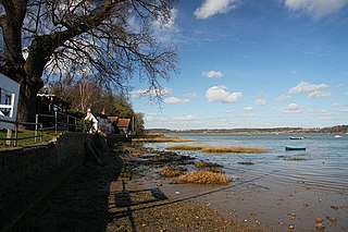
Bank of the River Orwell Bank of the River Orwell - geograph.org.uk - 1587541.jpg
Bank of the River Orwell

The River Orwell flows through the county of Suffolk in England from Ipswich to Felixstowe. Above Ipswich, the river is known as the River Gipping, but its name changes to the Orwell at Stoke Bridge, where the river becomes tidal. [1] It broadens into an estuary at Ipswich, where the Ipswich dock has operated since the 7th century, and then flows into the North Sea at Felixstowe, the UK's largest container port, after joining the River Stour at Shotley forming Harwich harbour.

Contents

The large Orwell Bridge carries the A14 trunk road over the estuary to the south of Ipswich.

Name

In the name Orwell, Or- comes from an ancient river-name—probably pre-Celtic; but -well probably indicates an Anglo-Saxon naming. [2] In A tour through England and Wales, written in 1722, Daniel Defoe calls the river "Orwel" (though he does this inconsistently). [3] He also mentions that "a traveller will hardly understand me, especially a seaman, when I speak of the River Stour and the River Orwell at Harwich, for they know them by no other names than those of Maningtre-Water, and Ipswich-Water". The writer Eric Blair chose the pen name under which he would later become famous, "George Orwell," because of his love for the river. [4] [5] A few miles north of the Orwell is another Suffolk river, the Ore, and Orfordness, the village port of Orford with its historic castle.

Estuary

The estuary flows through different sections as it makes its way down from Ipswich to the sea: [6]

Freston Reach

Redgate Hard is located here. This hard is probably post medieval. [7]

April 2008 showing remains of Redgate Hard Freston Reach, River Orwell - geograph.org.uk - 765846.jpg
April 2008 showing remains of Redgate Hard
Freston Reach, January 2008 View across Freston Reach - geograph.org.uk - 661826.jpg
Freston Reach, January 2008

Downham Reach

A whale was beached on Downham Reach around 1816.

Beached whale as recorded by George Frost The Whale at Downham Reach George Frost (c1816).jpg
Beached whale as recorded by George Frost

Potters Reach

Potters Reach, August 2009 Potter's Reach of the Orwell estuary - geograph.org.uk - 1432814.jpg
Potters Reach, August 2009

Lower Reach

At this point the Stour flows into the Orwell by Shotley Point. [6]

Sailing

The Orwell provides a popular venue for sailing. Interest originally centred on the hamlet of Pin Mill (featured in two children's novels by Arthur Ransome: We Didn't Mean To Go To Sea and Secret Water ), which is home to the Pin Mill Sailing Club and its Hard. Ransome had kept his yacht Selina King at the Pin Mill anchorage in 1937–39.

Since the 1970s marinas have opened at Levington (Suffolk Yacht Harbour, pictured), Woolverstone, Fox's (just outside Ipswich), and two marinas in the old Ipswich Wet Dock. Woolverstone is home to the Royal Harwich Yacht Club that was for many years host to the Swordfish 15-foot racing dinghy built by Fairey Marine, in addition to its 12-foot Firefly, a derivative of the National 12-foot dinghy, both designed by the sailor Uffa Fox. It now hosts a broad range of sailing events, such as the annual 'Junior Race Week'.

Ipswich Barrier

Ipswich has in the past been affected by flooding, both fluvial flooding from water passing down the river Gipping, and tidal flooding from tidal surges passing up the estuary of the Orwell, with the river becoming much narrower near to the entrance to Ipswich Docks. In order to reduce this risk, the Environment Agency implemented a programme of works expected to cost a total of £58 million to improve the flood defences on both banks of the tidal river and of the Port of Ipswich. The work included the construction of the Ipswich tidal barrier, and because the work affected the right of navigation on the New Cut, the section of the Orwell immediately above the barrier site, it required an order to be issued under the Transport and Works Act 1992. The Ipswich Barrier Order was issued by the Secretary of State for the Environment, Food and Rural Affairs in August 2012. [8]

The barrier consists of a rising sector gate, 66 feet (20 m) wide and 30 feet (9 m) high, located just to the west of the entrance to the wet dock. In November 2014, a contract for £28 million was awarded to VBA, a joint venture between VolkerStevin, Boskalis Westminster and Atkins, for construction of the barrier and associated flood defences on the banks of the river. The barrier is designed to prevent tidal surges passing further up stream, and to enable downstream fluvial flows to be controlled. It provides better flood protection to some 1,500 homes and 400 business properties. The river at the barrier site was 180 feet (55 m) wide, but in order to allow the construction of the barrier and the commissioning of the gate, a large cofferdam, 98 feet (30 m) square, extending 20.6 metres (68 ft) downwards into the chalk bed of the river, was formed against the east bank. This left a much narrower channel to allow the river flows to reach the estuary and boats to continue to access the river above the barrier site. [8]

The sector gate was designed by the German firm IRS, and was manufactured in Holland by Hollandia. Once assembled, it was floated across the North Sea, and lifted into the concrete support structure by a 600 tonne crane. The position of the gate is moved by two hydraulic cylinders, and it can be positioned to prevent a tidal surge passing up stream, or to regulate the downstream flow of the river. The concrete structure was tied in to the eastern bank early in the project, but ties to the western bank had to wait until the gate had been commissioned. At that point, both the flow of the river and boats could pass through the new structure, and the side channel could be blocked off. [8] The new barrier was officially opened in early February 2019 by Therese Coffey, Floods Minister at the Department for Environment, Food and Rural Affairs, by which time the cost of the project had risen to £67.4 million. While most of the funding came from the Environment Agency, some was also provided by Ipswich Borough Council, the New Anglia Local Enterprise Partnership, the Regional Flood and Coastal Committee, and UK Power Networks. [9]

The Yangtse Incident

The 1957 film Yangtse Incident: The Story of HMS Amethyst was filmed on the river. The naval shore establishment at HMS Ganges also featured in the film being used as a site for Chinese gun batteries. [10]

Bibliography

Related Research Articles

<span class="mw-page-title-main">River Stour, Suffolk</span> River in East Anglia, England

The River Stour is a major river in East Anglia, England. It is 47 miles (76 km) long and forms most of the county boundary between Suffolk to the north, and Essex to the south. It rises in eastern Cambridgeshire, passes to the east of Haverhill, through Cavendish, Sudbury, Bures, Nayland, Stratford St Mary and Dedham. It becomes tidal just before Manningtree in Essex and joins the North Sea at Harwich.

<span class="mw-page-title-main">River Gipping</span> River in Suffolk, England

The River Gipping is the source river for the River Orwell in the county of Suffolk in East Anglia, England, which is named from the village of Gipping, and which gave its name to the former Gipping Rural District. It rises near Mendlesham Green and flows in a south-westerly direction to reach Stowmarket. From there it flows towards the south or south east, passing through Needham Market then Baylham. The river continues to flow south between Great Blakenham and Claydon, and through Bramford and Sproughton until it flows into Ipswich, where it becomes the Orwell at Stoke Bridge. The river has supplied power to a number of watermills, several of which are still standing. None are operational, although the mill at Baylham retains most of its machinery, and is the only complete mill on the river.
<span class="mw-page-title-main">Felixstowe</span> Port town in Suffolk, England

Felixstowe is a port town and civil parish in the East Suffolk district, in the county of Suffolk, England. The estimated population in 2017 was 24,521. The Port of Felixstowe is the largest container port in the United Kingdom. Felixstowe is approximately 72 miles (116 km) northeast of London.

<span class="mw-page-title-main">The Haven, Boston</span> River in Lincolnshire, England

The Haven is the tidal river of the port of Boston, Lincolnshire in England. It provides access for shipping between Boston Deeps in The Wash and the town, particularly, the dock. It also serves as the outfall into the sea, of the River Witham and of several major land drains of the northern Fens of eastern England, which are known collectively as the Witham Navigable Drains..

<span class="mw-page-title-main">Suffolk and Ipswich Football League</span> Association football league in England

The Suffolk and Ipswich Football League is a football competition based in Suffolk, England. The league has a total of eight divisions; the Senior Division and Divisions 1–3 for first teams, three divisions for reserve teams, and Division 4, which is for open to both first teams and reserves and is subordinate to both Division 3 and League C. The Senior Division is at step 7 of the National League System. The league was founded in 1896 as the Ipswich & District League changing its name in 1978.

<span class="mw-page-title-main">Alton Water</span> Reservoir near Ipswich, Suffolk, England

Alton Water is a manmade reservoir located on the Shotley peninsula. It is the largest in Suffolk, with a perimeter of over 8 miles (13 km).

<span class="mw-page-title-main">River Deben</span> River in Suffolk, England

The River Deben is a river in Suffolk rising to the west of Debenham, though a second, higher source runs south from the parish of Bedingfield. The river passes through Woodbridge, turning into a tidal estuary before entering the North Sea at Felixstowe Ferry. The mouth of the estuary is crossed by a ferry connecting Felixstowe and Bawdsey.
<span class="mw-page-title-main">Shotley</span> Human settlement in England

Shotley is a village and civil parish 8 miles (13 km) south-east of Ipswich in the English county of Suffolk. It is in the Babergh district and gives its name to the Shotley peninsula between the Rivers Stour and Orwell. The parish includes the village of Shotley and the settlements of Shotley Gate and Church End. In 2011 civil parish had a population of 2,342. In reference to the 2021 census, the population of Shotley was 550.

<i>Yangtse Incident: The Story of H.M.S. Amethyst</i> 1957 British film by Michael Anderson

Yangtse Incident: The Story of H.M.S. Amethyst (1957) is a British war film that tells the story of the British sloop HMS Amethyst caught up in the Chinese Civil War and involved in the 1949 Yangtze Incident. Directed by Michael Anderson, it stars Richard Todd, William Hartnell, and Akim Tamiroff.

<span class="mw-page-title-main">Haven ports</span> Group of five ports in Essex and Suffolk, England

The Haven ports are a group of ports on the east coast of England. Traditionally, only the three deep-water ports of Ipswich, Harwich and Felixstowe, on the confluence of the River Orwell and River Stour, were included. The name has since changed to mean the following five ports:

The ferries in Suffolk are a series of local ferry services in the county of Suffolk in Eastern England. Most cross rivers within the county, and one connects Suffolk with Essex to the south.

<span class="mw-page-title-main">Port of Ipswich</span> Major port in Suffolk, England

The Port of Ipswich can be dated to c.625. The name Ipswich was originally Gippeswyc, referring to the River Gyppes with a suffix derived from the Scandinavian term vik, which had evolved from meaning bay or inlet to mean landing-place, following the proliferation of merchants requiring places to unload their goods and conduct trade. Since 1997 the port has been run by Associated British Ports.
<span class="mw-page-title-main">Shotley Gate</span> Human settlement in England

Shotley Gate is a settlement in the civil parish of Shotley, in the Babergh district, in the county of Suffolk, England. It is located at the tip of Shotley Peninsula and is the largest settlement in the parish of Shotley, in 2020 it had an estimated population of 1461. Shotley Gate has a pub called the Bristol Arms the settlement of Shotley Gate developed either side of Bristol Hill.

<span class="mw-page-title-main">Woolverstone</span> Human settlement in England

Woolverstone is a small village and civil parish in Suffolk, England located on the Shotley peninsula. It is situated about 6.4 km (4.0 mi) south of Ipswich, near the southern shore of the River Orwell. In 2005 it had a population of 240, increasing to 265 at the 2011 census.

<span class="mw-page-title-main">Ipswich Waterfront</span>

The Ipswich Waterfront is a cultural and historically significant area surrounding the marina in the town of Ipswich, Suffolk, England. The modern dock was constructed in 1842 and the area was a functioning dock up until the 1970s. At the time of completion, the dock was known as 'the biggest and most important enclosed dock in the kingdom'. Although the dock as it stands was constructed in 1842, the area was used for trade as far back as the 7th century. The decline of industry in the town resulted in the area being transformed into a trendy area of Ipswich, the waterfront is now characterised by its marina, known as Neptune Marina, as well as its mix of classical and postmodern architecture which includes multiple high-rise apartment buildings, restaurants, bars and cafés. The waterfront is also home to the main campus of the region's university, the University of Suffolk.

The Shotley Peninsula is a rural area east of the A137 Ipswich-Colchester road located between the rivers Stour and Orwell in Suffolk, England. The peninsula is named after the settlements of Shotley and Shotley Gate which are situated near its south-eastern tip. Other villages on the peninsula include Chelmondiston, Erwarton (Arwarton), Freston, Harkstead, Holbrook, Stutton, Tattingstone, Wherstead and Woolverstone.

<span class="mw-page-title-main">Pin Mill</span> Human settlement in England

Pin Mill is a hamlet on the south bank of the tidal River Orwell, on the outskirts of the village of Chelmondiston, on the Shotley peninsula in southern Suffolk. It lies within the Suffolk Coast and Heaths Area of Outstanding Natural Beauty and is a designated Conservation Area. It is now generally known for the historic Butt and Oyster public house, and for sailing.

<i>Orwell Lady</i>

The Orwell Lady is a purpose built river cruiser currently operating 13 miles of the river Orwell and sails from Ipswich, England. The Orwell lady is 57 ft (17.13m) long and 14 ft (4.26m) in the beam, weighs 42 tonnes, and carries 118 passengers plus crew. The Orwell Lady sails from Ipswich dock and sails to the end of the Orwell at the Port of Felixstowe allowing for views of Shotley harbour and the historic town of Harwich. The boat has a fully functioning bar and panoramic views which has helped secure the boat as a popular tourist attraction in Ipswich. In recent years the boat has become one of the most popular river cruises in East Anglia.
<span class="mw-page-title-main">Orwell Estuary</span>

Orwell Estuary is a 1,335.7 hectare biological Site of Special Scientific Interest which stretches along the River Orwell and its banks between Felixstowe and Ipswich in Suffolk. It is part of the Stour and Orwell Estuaries Ramsar site internationally important wetland site and Special Protection Area under the European Union Directive on the Conservation of Wild Birds. It is also in the Suffolk Coast and Heaths Area of Outstanding Natural Beauty.

References

  1. White, William (1844). History, gazetteer, and directory of Suffolk, and the towns near its borders. R. Leader. pp. 62–63.
  2. A D Mills: A dictionary of British place-names. Oxford: Oxford University Press, 2003. ISBN   0-19-852758-6
  3. Daniel Defoe, A tour through England and Wales, J.M. Dent and Sons Ltd, London (1959) Available online here
  4. "George Orwell Biography". Archived from the original on June 21, 2006. Retrieved 2006-07-09.
  5. Lederer, Richard (1999). The Miracle of Language . Simon and Schuster. p.  134. ISBN   0-671-02811-1.
  6. 1 2 WashingtonEdmund George Irving (1966). Admiralty Chart No 2693 Approaches to Harwich. London: Admiralty.
  7. "WHR 053 - Redgate Hard -". Suffolk Heritage Explorer. Suffolk County Council. Retrieved 19 February 2023.
  8. 1 2 3 VBA 2017.
  9. "£67.4 million Ipswich tidal flood barrier officially opened". Government Press Release. 8 February 2019. Archived from the original on 23 July 2019.
  10. "The Yangtse Incident:the story of HMS Amethyst". British Lion Films. British Lion Holdings Ltd. Archived from the original on 7 August 2016. Retrieved 27 April 2016.

51°58′N1°18′E / 51.967°N 1.300°E / 51.967; 1.300