Framlingham Mere

Last updated
Framlingham Mere
Framlingham Mere 11.jpg
Type Nature reserve
Location Framlingham, Suffolk
Area 13.8 hectares
Managed by Suffolk Wildlife Trust

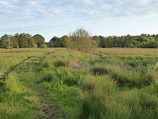
Framlingham Mere is a 13.8 hectare nature reserve in Framlingham in Suffolk. It is managed by the Suffolk Wildlife Trust. [1]

Framlingham town in Suffolk Coastal, Suffolk, England

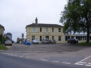
Framlingham is a market town and civil parish in Suffolk, England. Of Anglo-Saxon origin, it is mentioned in the Domesday Book. It had a population of 3,342 at the 2011 Census. Nearby villages include Earl Soham, Kettleburgh, Parham, Saxtead and Sweffling.

Suffolk County of England

Suffolk is an East Anglian county of historic origin in England. It has borders with Norfolk to the north, Cambridgeshire to the west and Essex to the south. The North Sea lies to the east. The county town is Ipswich; other important towns include Lowestoft, Bury St Edmunds, Newmarket and Felixstowe, one of the largest container ports in Europe.

Suffolk Wildlife Trust

Suffolk Wildlife Trust (SWT) describes itself as the county's "nature charity – the only organisation dedicated wholly to safeguarding Suffolk's wildlife and countryside." It is a registered charity, and its headquarters is at Brooke House in Ashbocking, near Ipswich. It was founded in 1961, and is one of 47 wildlife trusts covering the Great Britain and Northern Ireland. As of March 2017, it has 13,200 members, and it manages 3,120 hectares of land in 60 nature reserves, most of which are open to the public. It had an income of £3.9 million in the year to 31 March 2017.

This site has a lake and wet meadows adjoining Framlingham Castle. There are many migrating birds, and flora include marsh marigolds, ragged-robin and lady's smock. [1]

Framlingham Castle Grade I listed historic house museum in Framlingham, United Kingdom

Framlingham Castle is a castle in the market town of Framlingham in Suffolk in England. An early motte and bailey or ringwork Norman castle was built on the Framlingham site by 1148, but this was destroyed by Henry II of England in the aftermath of the revolt of 1173–4. Its replacement, constructed by Roger Bigod, the Earl of Norfolk, was unusual for the time in having no central keep, but instead using a curtain wall with thirteen mural towers to defend the centre of the castle. Despite this, the castle was successfully taken by King John in 1216 after a short siege. By the end of the 13th century, Framlingham had become a luxurious home, surrounded by extensive parkland used for hunting.

There is access from New Road and by a footpath past the castle from Badingham Road.

Related Research Articles

Framlingham College

Framlingham College is an independent, coeducational boarding and day school in the town of Framlingham, near Woodbridge, Suffolk, England. Together with its preparatory school and nursery at Brandeston Hall, it serves pupils from 2 to 18 years of age.

Framlingham railway station

Framlingham railway station was located in Framlingham, Suffolk, UK and was the terminus station on the Framlingham Branch.

Newbourne Springs Suffolk Wildlife Trust nature reserve

Newbourne Springs is a 15.7 hectare biological Site of Special Scientific Interest in Newbourne in Suffolk. It is owned by Anglian Water and managed by the Suffolk Wildlife Trust.

Thorington village in the United Kingdom

Thorington is a village and a civil parish in the hundred of Blything, in the Suffolk Coastal District of the English county of Suffolk. It is located around 3 miles (4.8 km) south-east of the town of Halesworth, immediately south of the village of Wenhaston. The A12 main road runs through the parish to the east of the village.

Saxtead Green is a village on the A1120 road and the B1119 road, near the village of Saxtead and the town of Framlingham, in the Suffolk Coastal District, in the English county of Suffolk.

Framlingham Town F.C.

Framlingham Town Football Club is a football club based in Framlingham, Suffolk, England. Affiliated to the Suffolk County Football Association, they are currently members of the Eastern Counties League Premier Division and play at Badingham Road.

Groton Wood Suffolk Wildlife Trust nature reserve

Groton Wood is a 20.2 hectare biological Site of Special Scientific Interest north-east of Groton in Suffolk. It is owned and managed by the Suffolk Wildlife Trust.

Captains Wood Suffolk Wildlife Trust nature reserve

Captain's Wood is a 62 hectare nature reserve in Sudbourne in Suffolk. It is owned and managed by the Suffolk Wildlife Trust.

Cornard Mere Suffolk Wildlife Trust nature reserve

Cornard Mere is an 8.5 hectare biological Site of Special Scientific Interest in Little Cornard in Suffolk. It is managed by the Suffolk Wildlife Trust.

Darsham Marshes Suffolk Wildlife Trust nature reserve

Darsham Marshes is a 20 hectare nature reserve south of Darsham in Suffolk, England. It is owned and managed by the Suffolk Wildlife Trust.

Sizewell Belts Suffolk Wildlife Trust nature reserve

Sizewell Marshes is a 105.4 hectare biological Site of Special Scientific Interest adjacent to Sizewell in Suffolk. It is in the Suffolk Coast and Heaths Area of Outstanding Natural Beauty, and is part of a 144 hectare nature reserve managed by the Suffolk Wildlife Trust as Sizewell Belts.

Martins Meadows Suffolk Wildlife Trust nature reserve

Monewden Meadows is a 3.7 hectare biological Site of Special Scientific Interest south-west of Monewden in Suffolk. It is a Nature Conservation Review site, Grade I, and it is managed by the Suffolk Wildlife Trust under the name Martins' Meadows.

Sutton and Hollesley Heaths Suffolk Wildlife Trust nature reserve

Sutton and Hollesley Heaths is a 483.3 hectare biological Site of Special Scientific Interest south-east of Woodbridge in Suffolk. Most of the site is managed by the Suffolk Wildlife Trust as Sutton and Hollesley Commons. It is part of the Sandlings Special Protection Area under the European Union Directive on the Conservation of Wild Birds, and the Suffolk Coast and Heaths Area of Outstanding Natural Beauty.

Mellis Common Suffolk Wildlife Trust nature reserve

Mellis Common is a 59 hectare nature reserve in Mellis in Suffolk. It is managed by the Suffolk Wildlife Trust.

Sir Robert Hitchams Almshouses

Sir Robert Hitcham's Almshouses are grade II* listed almshouses in New Road, Framlingham, Suffolk, England.

Church Farm Marshes Suffolk Wildlife Trust nature reserve

Church Farm Marshes is a 56 hectare nature reserve in Thorington in Suffolk. It is managed by the Suffolk Wildlife Trust.

Lound Lakes Suffolk Wildlife Trust nature reserve

Lound Lakes is a 113 hectare nature reserve between Browston Green and Hopton in Suffolk. It is owned by Essex and Suffolk Water and managed by the Suffolk Wildlife Trust.

Mickle Mere Suffolk Wildlife Trust nature reserve

Mickle Mere is a 17 hectare nature reserve south of Ixworth in Suffolk. It is managed by the Suffolk Wildlife Trust.

References

  1. 1 2 "Framlingham Mere". Suffolk Wildlife Trust. Retrieved 24 July 2017.

Coordinates: 52°13′23″N1°20′28″E / 52.223°N 1.341°E / 52.223; 1.341

Geographic coordinate system Coordinate system

A geographic coordinate system is a coordinate system that enables every location on Earth to be specified by a set of numbers, letters or symbols. The coordinates are often chosen such that one of the numbers represents a vertical position and two or three of the numbers represent a horizontal position; alternatively, a geographic position may be expressed in a combined three-dimensional Cartesian vector. A common choice of coordinates is latitude, longitude and elevation. To specify a location on a plane requires a map projection.