River Stiffkey

Last updated

River Stiffkey
RiverStiffkeyFordNearGreatWalsingham(DavidWilliams)Sep2004.jpg
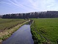
Crossing Ford near Great Walsingham
Norfolk UK relief location map.jpg
Red pog.svg
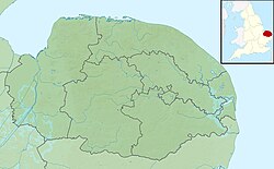
River Stiffkey within North Norfolk
Location
Country England
State Norfolk
Region East of England
District North Norfolk
Physical characteristics
Source 
  location Swanton Novers
  coordinates 52°51′20″N0°59′46″E / 52.8555°N 0.9962°E / 52.8555; 0.9962
  elevation90 m (300 ft)
Mouth Freshes creek
  location
behind the spit, Blakeney Point
  coordinates
52°57′27″N0°57′40″E / 52.9574°N 0.9610°E / 52.9574; 0.9610
  elevation
0 m (0 ft)
Length18 mi (29 km)
Basin features
WatermillsLittle Walsingham

The River Stiffkey is a chalk stream running through an area of north Norfolk, England from its source near Swanton Novers to flow out into the North Sea on the north Norfolk coast near the village of Stiffkey. The river has been dredged historically, presumably for agricultural purposes, and has a self-sustaining population of brown trout. [1]

Contents

Course

The river's source is a small wooded lake just north of the village of Swanton Novers, after which the river passes close to Fulmodeston, then north to pass through the village of Great Snoring, which is noted in the Domesday book as having a watermill. From Great Snoring [2] it runs south past Thorpland Hall, [2] then north-west through East Barsham, [2] North Barsham and Houghton St Giles to Little Walsingham, the largest settlement on its course.

The Priory in Little Walsingham was built with stone from Northamptonshire which had been towed up the River Stiffkey in flat-bottomed barges. The priory had a watermill on the river but this was demolished early in the 20th century. [3]

From here it flows north past Great Walsingham, then through Wighton and Warham before passing through the village of Stiffkey and out to its estuary on Stiffkey Salt Marshes. [2] The area from Great Walsingham to Stiffkey is prone to flooding and was the subject of a severe flood warning in October 2004. [4]

History

The river is probably named after the village of Stiffkey, whose name means "Island with tree-stumps". [5]

Related Research Articles

<span class="mw-page-title-main">River Wensum</span> River in Norfolk, England

The River Wensum is a chalk river in Norfolk, England and a tributary of the River Yare, despite being the larger of the two rivers. The river is a biological Site of Special Scientific Interest and Special Area of Conservation.

<span class="mw-page-title-main">River Nene</span> River in eastern England

The River Nene is a river in the east of England that rises from three sources in Northamptonshire. The river is about 105 miles (169 km) long, about 3.7 miles (6.0 km) of which forms the border between Cambridgeshire and Norfolk. It is the tenth-longest river in the United Kingdom, and is navigable for 88 miles (142 km), from Northampton to The Wash.

<span class="mw-page-title-main">Walsingham</span> Civil parish in Norfolk, England

Walsingham is a civil parish in North Norfolk, England, famous for its religious shrines in honour of Mary, mother of Jesus. It also contains the ruins of two medieval monastic houses. Walsingham is 27 miles (43 km) northwest of Norwich.

<span class="mw-page-title-main">North Norfolk</span> District in Norfolk, England

North Norfolk is a local government district in Norfolk, England. Its council is based in Cromer, and the largest town is North Walsham. The district also includes the towns of Fakenham, Holt, Sheringham, Stalham and Wells-next-the-Sea, along with numerous villages and surrounding rural areas.

<span class="mw-page-title-main">Stiffkey</span> Human settlement in England

Stiffkey is a village and civil parish on the north coast of the English county of Norfolk. It is situated on the A149 coast road, some 6 km (3.7 mi) east of Wells-next-the-Sea, 6 km (3.7 mi) west of Blakeney, and 40 km (25 mi) north-west of the city of Norwich. The civil parish has an area of 14.55 km2 (5.62 sq mi) and in the 2001 census had a population of 223 in 105 households, the population falling to 209 at the 2011 Census.

<span class="mw-page-title-main">River Burn, Norfolk</span> River in northwest Norfolk, England

The River Burn is a river in the northwest of the County of Norfolk, in the East of England. From its source to its mouth on the North Coast of Norfolk it is 12.3 kilometres (7.6 mi). The river has a fall of 36 metres to the sea.

<span class="mw-page-title-main">Wells and Walsingham Light Railway</span> Heritage railway in North Norfolk, England

The Wells and Walsingham Light Railway is a 10+14 in gauge heritage railway in Norfolk, England running between the coastal town of Wells-next-the-Sea and the inland village of Walsingham. The railway occupies a four-mile (6.4 km) section of the trackbed of the former Wymondham to Wells branch which was closed to passengers in stages from 1964 to 1969 as part of the Beeching cuts. Other parts of this line, further south, have also been preserved by the Mid-Norfolk Railway.

Barsham is a civil parish in the English county of Norfolk, and includes the villages of East Barsham, North Barsham, West Barsham and Houghton St Giles. The villages are all situated within 2 miles of each other, about 3 miles north of the town of Fakenham and 28 miles north-west of the city of Norwich. The headwaters of the River Stiffkey flow through both East and North Barsham and Houghton St Giles.

<span class="mw-page-title-main">Wighton</span> Human settlement in England

Wighton is a village and civil parish in the English county of Norfolk. The village is situated some 6 km (3.7 mi) south of the town of Wells-next-the-Sea, 12 km (7.5 mi) north of the town of Fakenham, and 45 km (28 mi) north-west of the city of Norwich. The medieval pilgrimage centre of Walsingham lies 3 km (1.9 mi) to the south.

<span class="mw-page-title-main">Great Snoring</span> Village in Norfolk, England

Great Snoring is a rural village in North Norfolk by the River Stiffkey, in the east of England. It is situated approximately 25 miles (40 km) north-west from the city and county town of Norwich, and 2 miles (3 km) north from the larger village of Little Snoring.

<span class="mw-page-title-main">Warham, Norfolk</span> Human settlement in England

Warham is a village and civil parish in the English county of Norfolk. It is situated about 5 km (3.1 mi) inland from the north Norfolk coast, 5 km (3.1 mi) south-east of the town of Wells-next-the-Sea and 50 km (31 mi) north-west of the city of Norwich.

<span class="mw-page-title-main">Weybourne, Norfolk</span> Village in Norfolk, England

Weybourne is a village on the coast of North Norfolk, England. The village is surrounded by arable fields, woodland and heathland; it straddles the A149 coast road, 3 miles (5 km) west of Sheringham, within the Norfolk Coast AONB. The area is popular for its local countryside and coastline, particularly for walking, wildlife and bird-watching.

<span class="mw-page-title-main">A149 road</span> Road in Norfolk, linking Kings Lynn and Great Yarmouth

The A149 is commonly known as "The Coast Road" to local residents and tourists, as this road runs along the North Norfolk coast from King's Lynn to Great Yarmouth, via coastal villages.

<span class="mw-page-title-main">River Babingley</span> River in northwest Norfolk, England

The Babingley is a minor river in the northwest of the county Norfolk in England. It runs 12.2 miles (19.6 km) from its source at the village of Flitcham to the River Great Ouse at Wootton Marshes where it terminates.

<span class="mw-page-title-main">River Ingol</span> River in Norfolk, England

The River Ingol is a small river in the west of the English county of Norfolk.

<span class="mw-page-title-main">Spring Beck</span> Minor watercourse in Norfolk, England

Spring Beck is a minor watercourse flowing near and through the village of Weybourne in the north of the county of Norfolk.

<span class="mw-page-title-main">Swanton Novers</span> Human settlement in England

Swanton Novers is a village and a civil parish in the English county of Norfolk. The village is 15.1 miles (24.3 km) west-south-west of Cromer, 23.1 miles (37.2 km) north-north-west of Norwich and 123 kilometres (76 mi) north-north-east of London. The village lies 6 miles (9.7 km) south-west of the town of Holt. The nearest railway station is at Sheringham for the Bittern Line which runs between Sheringham, Cromer and Norwich. The nearest airport is Norwich International Airport.

<span class="mw-page-title-main">B1110 road</span> Road in England

The B1110 runs for about 19 miles (31 km) between Holt and Dereham, and is entirely within the county of Norfolk. The road is a link between the A148 and the A47 at the town of Dereham.

<span class="mw-page-title-main">Aldeby Priory</span>

Aldeby Priory was a 12th-century Benedictine monastic house in Aldeby, Norfolk, England.

References

  1. Vaughan Lewis, Windrush AEC on behalf of Tom Coke, Holkham Estate and Nick Zoll (2002). "Habitat Advisory Visit, Rivers Stiffkey and Burn, Norfolk" (PDF). originally available as www.wildtrout.org/WWT/library/papers/AU18.pdf. Retrieved 14 April 2006.{{cite web}}: CS1 maint: multiple names: authors list (link)[ dead link ]
  2. 1 2 3 4 "Rivers of East Anglia, By James Turner: Publisher: Cassell & Company Limited, 1954, Chapter III The Stiffkey.:AASIN B0007JD6TQ
  3. Jonathan Neville (2003). "Norfolk Mills - Little Walsingham watermill". Norfolk Mills. Retrieved 14 April 2006.
  4. National Flood Warning Centre (2006). "River Stiffkey from, and including Great Walsingham to Stiffkey". Environment Agency. Archived from the original on 27 May 2005. Retrieved 1 April 2006.
  5. A. D. Mills. A Dictionary of British Place Names. Oxford University Press.