The River Wensum is a chalk river in Norfolk, England and a tributary of the River Yare, despite being the larger of the two rivers. The river is a biological Site of Special Scientific Interest and Special Area of Conservation.

Tarbell Brook is a 10.1-mile-long (16.3 km) stream located in southwestern New Hampshire and northern Massachusetts in the United States. It is a tributary of the Millers River, itself a tributary of the Connecticut River, which flows to Long Island Sound.
Uppermill or Upper Mill may refer to:

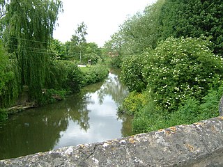
The River Glaven in the eastern English county of Norfolk is 10.5 miles (16.9 km) long and flows through picturesque North Norfolk countryside to the North Sea. Rising from a tiny headwater in Bodham the river starts 2½ miles before Selbrigg Pond where three small streams combine. The scenic value of the Glaven valley is important to the tourist industry in North Norfolk. The river is one of over 200 chalk rivers in the world and one of 160 in the UK.

The Babingley is a minor river in the northwest of the county Norfolk in England. It runs 12.2 miles (19.6 km) from its source at the village of Flitcham to the River Great Ouse at Wootton Marshes where it terminates.

Gaywood River is a tributary of the River Great Ouse in the west of the county of Norfolk. Its source is 11 metres above sea level, northwest of the village of Gayton in Derby Fen, Map Reference TF 705 209. It runs for 6.7 miles (10.8 km) to its outflow into the River Great Ouse in the town of King's Lynn.
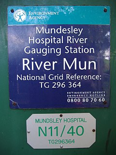
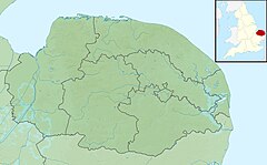
The River Mun or Mundesley Beck is a river in the north of the county of Norfolk, England. The source of the river can be found in the Parish of Northrepps. The river finally runs into the North Sea in the village of Mundesley.

Beeston Beck is a minor watercourse in the north of the county of Norfolk, England.
Lenwade is a village in the civil parish of Great Witchingham, Norfolk, situated in the Wensum Valley adjacent to the A1067 road 14 miles (23 km) south-east of Fakenham and some 11 miles (18 km) north-west of Norwich. The River Ainse joins the Wensum at Lenwade. The population of the village is included in the civil parish of Great Witchingham.

Scarrow Beck is a minor watercourse which rises in the north of the English county of Norfolk. It is a tributary of the River Bure. It's spring is in the North Norfolk village of Aylmerton west of the main street. It eventually merges, after 7.7 miles (12.4 km) with the River Bure at Ingworth just north of the Blickling Hall estate. There are two watermills on the beck, both of which are no longer in working order. A third windmill at Gresham stands on Gur Beck, a small tributary of Scarrow Beck.
The River Beult is a tributary of the River Medway in South East England.

Gur Beck is a minor watercourse which rises in the north of the English county of Norfolk. It is a tributary of the Scarrow Beck. Its spring is a little east of the North Norfolk village of West Beckham. It eventually merges after 4.2 miles (6.8 km) with the Scarrow Beck at Sustead. There is one watermill on the beck. This can be found in the village of Gresham, but is no longer in working order.

Hagon Beck is a minor watercourse which rises in the north of the English county of Norfolk. It falls into Great Lake in Gunton Park, which in turn feeds Suffield Beck. Suffield Beck is a tributary of Blackwater Beck which in turn joins the River Bure. Its spring is a little north of the North Norfolk village of Roughton. There were two watermills on the beck. The first was located at Gunton, and the second is a sawmill in Suffield Park.

Hempstead Watermill is a disused watermill 1.7 miles south east of the town of Holt in the English county of Norfolk. The mill stands on the River Glaven and the lane between Holt and the village of Hempstead. The mill was built in 1830 by Richard John Gurney and was originally called Holt Watermill.

Glandford watermill is situated on the River Glaven a little north of the village of Glandford within the English county of Norfolk. Glandford is in the civil parish of Wiveton within the district of North Norfolk.
New Mill or Newmill may refer to:

Union Mills or Roy's Mills are a Grade II listed combined tower mill and watermill at Burnham Overy, Norfolk, England which has been converted to residential accommodation.

Narborough Watermill is located on the river Nar, within the village of Narborough in the English county of Norfolk. The watermill is thought to have been built around 1780 and is a Grade II listed building

Calthorpe is a small village within the civil parish of Erpingham in the English county of Norfolk, England. The village is located 0.5 miles (0.80 km) west of the village of Erpingham, 3.4 miles (5.5 km) north of the nearest town of Aylsham and is 15.8 miles (25.4 km) north of the nearest city of Norwich. The nearest railway station is at Gunton for the Bittern Line which runs between Sheringham, Cromer and Norwich and is 7.8 miles (12.6 km) from the village. The nearest airport is Norwich International 14.2 miles (22.9 km) south of the village.

The Mermaid (river) is a minor tributary of the River Bure in Norfolk, England, and is approximately 6 kilometres (3.7 mi) in length.