
A tide mill is a water mill driven by tidal rise and fall. A dam with a sluice is created across a suitable tidal inlet, or a section of river estuary is made into a reservoir. As the tide comes in, it enters the mill pond through a one-way gate, and this gate closes automatically when the tide begins to fall. When the tide is low enough, the stored water can be released to turn a water wheel.
Letheringsett with Glandford is a civil parish in the English county of Norfolk. It includes the village of Letheringsett, along with the hamlet of Glandford. The village straddles the A148 King’s Lynn to Cromer road. Letheringsett is 1.2 miles west of Holt, 32.2 west north east of King’s Lynn and 126 miles north north east of London. The nearest railway station is at Sheringham for the Bittern Line which runs between Sheringham, Cromer and Norwich. The nearest airport is Norwich International Airport.

Heacham River is a small river in the King's Lynn and West Norfolk district of the English County of Norfolk. Its source is near the village of Bircham Newton grid reference TF762 339, 25 metres above sea level. The river is 16.4 kilometres (10.2 mi) long from the source to the outfall on Heacham beach, which discharges into The Wash at low tide.
Buxton Mill, is located on the River Bure about 0.5 miles (0.80 km) east of the village of Buxton, Norfolk, and is in the hamlet of Lamas, Norfolk. A watermill was recorded here in the Domesday Book. The present mill is thought to date from 1754 and was built by William Pepper, a merchant living in Buxton.
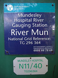
The River Mun or Mundesley Beck is a river in the north of the county of Norfolk, England. The source of the river can be found in the Parish of Northrepps. The river finally runs into the North Sea in the village of Mundesley.

The River Ingol is a small river in the west of the English county of Norfolk.

Beeston Beck is a minor watercourse in the north of the county of Norfolk, England.
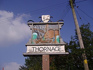
Thornage is a village and a civil parish in the English county of Norfolk. The village is 2.7 miles south-west of Holt, 23.2 miles north-west of Norwich and 11.3 miles east of Fakenham, and straddles the B1110 road between Holt and Guist. The nearest railway station is at Sheringham for the Bittern Line which runs between Sheringham, Cromer and Norwich. The nearest airport is at Norwich International Airport.

Hagon Beck is a minor watercourse which rises in the north of the English county of Norfolk. It falls into Great Lake in Gunton Park, which in turn feeds Suffield Beck. Suffield Beck is a tributary of Blackwater Beck which in turn joins the River Bure. Its spring is a little north of the North Norfolk village of Roughton. There were two watermills on the beck. The first was located at Gunton, and the second is a sawmill in Suffield Park.

Hempstead Watermill is a disused watermill 1.7 miles south east of the town of Holt in the English county of Norfolk. The mill stands on the River Glaven and the lane between Holt and the village of Hempstead. The mill was built in 1830 by Richard John Gurney and was originally called Holt Watermill.

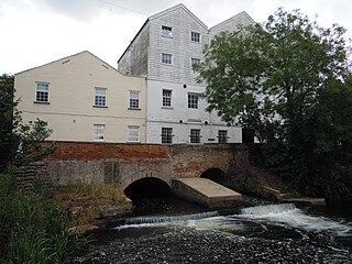
Letheringsett watermill is situated on the River Glaven in the village of Letheringsett within the English county of Norfolk. Letheringsett is in the district of North Norfolk and is 1.4 miles (2.3 km) west of the town of Holt. The watermill is a Grade II* listed building and is the last fully operational watermill in Norfolk that produces flour.

The remains of Letheringsett Brewery Watermill are located in the centre of the village of Letheringsett in the county of Norfolk. The watermill of 1784 was housed within the maltings and brewery complex founded and run by John Brereton of Letheringsett Hall from before 1721. Much of this complex still stands on the south side of the A148 Cromer to King’s Lynn road, which bisects the village on an east-west axis, and on the west bank of the River Glaven, which bisects the village south-north.

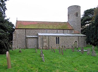
Hunworth is a village within the civil parish of Stody(where the population is from 2011 included) in the English county of Norfolk. The village is 11.5 miles (18.5 km) east-north-east of the town of Fakenham, 12.6 miles (20.3 km) west-south-west of Cromer and 125 miles (201 km) north-north-east of London. The nearest town is Holt which lies 3.4 miles (5.5 km) north of the village. The nearest railway station is at Sheringham for the Bittern Line which runs between Sheringham, Cromer and Norwich. The nearest airport is Norwich International Airport. The village is situated on the road between Holt and Briston. The parish of Stody, within which Hunworth is located, had, in the 2001 census, a population of 101, being less than 100 at the 2011 Census. For the purposes of local government, the parish falls within the district of North Norfolk.

Narborough Watermill is located on the river Nar, within the village of Narborough in the English county of Norfolk. The watermill is thought to have been built around 1780 and is a Grade II listed building
Sir Alfred Jodrell, 4th Baronet (1847-1929) was the fourth and last of the Jodrell Baronets, assuming the title in 1882. The title became extinct on his death. Jodrell married Jane Grimston, daughter of James Grimston, 2nd Earl of Verulam.

Blakeney Chapel is a ruined building on the Norfolk coast of England. Despite its name, it is in the parish of Cley next the Sea, not the adjoining village of Blakeney, and was probably not a chapel. The building stood on a raised mound or "eye" on the seaward end of the coastal marshes, less than 200 m (220 yd) from the sea and just to the north of the current channel of the River Glaven where it turns to run parallel to the shoreline. It consisted of two rectangular rooms of unequal size, and appears to be intact in a 1586 map, but is shown as ruins in later charts. Only the foundations and part of a wall still remain. Three archaeological investigations between 1998 and 2005 provided more detail of the construction, and showed two distinct periods of active use. Although it is described as a chapel on several maps, there is no documentary or archaeological evidence to suggest that it had any religious function. A small hearth, probably used for smelting iron, is the only evidence of a specific activity on the site.

Stiffkey Fen is a nature reserve near Stiffkey, Norfolk. It is 14 ha (35 acres) in extent, and was created from farmland by Lord Buxton, who also, with the support of the Environment Agency, improved the wetland by slowing the water flow through the fen. The reserve has a reed bed and a fresh water lagoon and islands. It has a winter roost of up to 4,000 northern lapwings, and also hosts water rails and bearded tits.

The Roman River is a river that flows entirely through the English county of Essex. It is a tributary of the River Colne, flowing into its tidal estuary below Colchester. The lower end of the Roman River is also tidal, with tidal water flowing upstream to just above Fingringhoe.

Glandford is a 9.4-hectare (23-acre) geological Site of Special Scientific Interest west of Sheringham in Norfolk. It is a Geological Conservation Review site and it is in the Norfolk Coast Area of Outstanding Natural Beauty.


