The River Bure is a river in the county of Norfolk, England, most of it in the Broads. The Bure rises near Melton Constable, 11 miles (18 km) upstream of Aylsham, which was the original head of navigation. Nowadays, the head of navigation is 10 miles (16 km) downstream at Coltishall Bridge. After Aylsham Lock and Burgh Bridge, the Bure passes through Buxton Lammas, Coltishall, Belaugh, Wroxham, Horning, Ludham Bridge, past St. Benet's Abbey, through Oby, Acle, Stokesby, along the northern border of the Halvergate Marshes, through Runham and Great Yarmouth where it meets Breydon Water and flows into the sea at Gorleston.

The North Walsham and Dilham Canal is a waterway in the English county of Norfolk. It was authorised by Parliament in 1812, but work on the construction of a canal which ran parallel to a branch of the River Ant did not start until 1825. It included six locks, which were sized to accommodate wherries, and was officially opened in August 1826. It was 8.7 miles (14.0 km) long and ran from two bone mills at Antingham to a junction with the River Ant at Smallburgh. It carried offal for the bone mills and agricultural products, as it proved cheaper to land coal on the beach at Mundesley and cart it overland than to use the canal.

The River Welland is a lowland river in the east of England, some 65 miles (105 km) long. It drains part of the Midlands eastwards to The Wash. The river rises in the Hothorpe Hills, at Sibbertoft in Northamptonshire, then flows generally northeast to Market Harborough, Stamford and Spalding, to reach The Wash near Fosdyke. It is a major waterway across the part of the Fens called South Holland, and is one of the Fenland rivers which were laid out with washlands. There are two channels between widely spaced embankments with the intention that flood waters would have space in which to spread while the tide in the estuary prevented free egress. However, after the floods of 1947, new works such as the Coronation Channel were constructed to control flooding in Spalding and the washes are no longer used solely as pasture, but may be used for arable farming.

The River Great Ouse is a river in the United Kingdom, the longest of several British rivers called "Ouse". From Syresham in central England, the Great Ouse flows into East Anglia before entering the Wash, a bay of the North Sea. With a course of 143 miles (230 km), mostly flowing north and east, it is the one of the longest rivers in the United Kingdom. The Great Ouse has been historically important for commercial navigation, and for draining the low-lying region through which it flows; its best-known tributary is the Cam, which runs through Cambridge. Its lower course passes through drained wetlands and fens and has been extensively modified, or channelised, to relieve flooding and provide a better route for barge traffic. Though the unmodified river probably changed course regularly after floods, it now enters the Wash after passing through the port of King's Lynn, south of its earliest-recorded route to the sea.

The River Wissey is a river in Norfolk, eastern England. It rises near Bradenham, and flows for nearly 31 miles (50 km) to join the River Great Ouse at Fordham. The lower 11.2 miles (18.0 km) are navigable. The upper reaches are notable for a number of buildings of historic interest, which are close to the banks. The river passes through the parkland of the Arts and Crafts Pickenham Hall, and further downstream, flows through the Army's Stanford Training Area (STANTA), which was created in 1942 by evacuating six villages. The water provided power for at least two mills, at Hilborough and Northwold. At Whittington, the river becomes navigable, and is surrounded by fenland. A number of pumping stations pump water from drainage ditches into the higher river channel.
The Ouse is a river in the English counties of West and East Sussex. It rises near Lower Beeding in West Sussex, and flows eastwards and then southwards to reach the sea at Newhaven. It skirts Haywards Heath and passes through Lewes. It forms the main spine of an extensive network of smaller streams, of which the River Uck is the main tributary. As it nears the coast it passes through the Lewes and Laughton Levels, an area of flat, low-lying land that borders the river and another tributary, the Glynde Reach. It was a large tidal inlet at the time of the Domesday book in 1086, but over the following centuries, some attempts were made to reclaim some of the valley floor for agriculture, by building embankments, but the drainage was hampered by the buildup of a large shingle bar which formed across the mouth of the river by longshore drift.

Rendering is a process that converts waste animal tissue into stable, usable materials. Rendering can refer to any processing of animal products into more useful materials, or, more narrowly, to the rendering of whole animal fatty tissue into purified fats like lard or tallow. Rendering can be carried out on an industrial, farm, or kitchen scale.

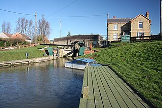
The Darent is a Kentish tributary of the River Thames and takes the waters of the River Cray as a tributary in the tidal portion of the Darent near Crayford, as illustrated by the adjacent photograph, snapped at high tide. 'Darenth' is frequently found in the spelling of the river's name in older books and maps, Bartholomew's "Canal's and River of England" being one example. Bartholomew's Gazetteer (1954) demonstrates that Darent means "clear water" and separately explains the other name. Considering the River Darent runs on a bed of chalk and its springs rise through chalk, this is not surprising. The original purity of the water was a major reason for the development of paper and pharmaceuticals in the area.

The Babingley is a minor river in the northwest of the county Norfolk in England. It runs 12.2 miles (19.6 km) from its source at the village of Flitcham to the River Great Ouse at Wootton Marshes where it terminates.

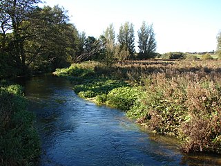
Narborough is a village of 1405 hectares in the Breckland district of Norfolk, England, with a population of 1,094 at the 2011 census. It is situated in the Nar Valley, with the river Nar flowing through on its way to the River Great Ouse.
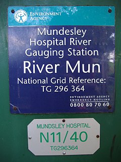
The River Mun or Mundesley Beck is a river in the north of the county of Norfolk, England. The source of the river can be found in the Parish of Northrepps. The river finally runs into the North Sea in the village of Mundesley.

Letheringsett watermill is situated on the River Glaven in the village of Letheringsett within the English county of Norfolk. Letheringsett is in the district of North Norfolk and is 1.4 miles (2.3 km) west of the town of Holt. The watermill is a Grade II* listed building and is the last fully operational watermill in Norfolk that produces flour.
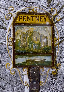
Pentney is a village and civil parish in the English county of Norfolk, located about 8 miles (13 km) south east of King's Lynn placing it about halfway between King's Lynn and Swaffham on the A47 road. It covers an area of 10.39 km2 (4.01 sq mi) and had a population of 387 in 184 households at the 2001 census, increasing to 544 at the 2011 Census. For the purposes of local government, it falls within the district of King's Lynn and West Norfolk. It is in the valley of the River Nar, a tributary of the River Great Ouse.
Downham West is a civil parish in the English county of Norfolk The parish is 47.6 miles (76.6 km) west of Norwich, 16.3 miles (26.2 km) south-south-west of King's Lynn and 96.2 miles (154.8 km) north of London. The nearest town is Downham Market which is 2.5 miles (4.0 km) north east of the parish. The nearest railway station is at Downham Market for the Fen Line which runs between King's Lynn and Cambridge. The nearest airport is Norwich International Airport. The parish of Downham West, in the 2001 census, has a population of 285, rising marginally to 286 at the Census 2011. For the purposes of local government, the parish falls within the district of King's Lynn and West Norfolk.

Union Mills or Roy's Mills are a Grade II listed combined tower mill and watermill at Burnham Overy, Norfolk, England which has been converted to residential accommodation.

Narborough Watermill is located on the river Nar, within the village of Narborough in the English county of Norfolk. The watermill is thought to have been built around 1780 and is a Grade II listed building