The headwaters of a river or stream is the farthest place in that river or stream from its estuary or downstream confluence with another river, as measured along the course of the river. It is also known as a river's source.

The Alatna River is a federally designated wild and scenic river partially contained within the boundaries of Gates of the Arctic National Park, Alaska. It is called one of the most beautiful rivers in the United States. The Alatna River stems from the central Brooks Range flowing through the Endicott Mountains, passing Circle Lake, the Arrigetch Peaks and Takahula Lake before entering the Helpmejack Hills. The last section of the river continues to flow in a SSE direction through the Alatna Hills into its confluence with the Koyukuk River near the small village of Allakaket. The first 25 miles (40 km) of the Alatna are shallow and rocky, followed by 15 miles (24 km) of a continued shallow area with more rapids. The river then mellows out near Takahula and Circle Lake becoming deeper and more meandering while the scenery turns from mountain peaks into hilly boreal forest. According to The Alaska River Guide, this river is 184 miles (296 km) long from the headwaters to Allakaket and 137 miles (220 km) from Circle Lake to Allakaket.
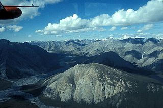
The Ivishak River is a 95-mile (153 km) tributary of the Sagavanirktok River in the North Slope Borough of the U.S. state of Alaska. Fed by glaciers at the headwaters, the Ivishak flows northeast, then northwest, through the Philip Smith Mountains and the northern foothills of the Arctic National Wildlife Refuge. It enters the Sagavanirktok River on the coastal plain south of Prudhoe Bay.

The River Roden is a river in Shropshire, England, which rises near Wem Moss where the Llangollen Canal passes above its headwaters. It flows south east and meets the River Tern at Walcot.

Lake Louisa State Park is a 4,372-acre (17.69 km2) Florida State Park located south of Clermont, in the northeast corner of the Green Swamp and the southwestern shore of Lake Louisa. It is made up of bald cypress, live oak, and saw palmettos. In addition to Lake Louisa, the park contains Hammond Lake, Dixie Lake, Dude Lake, and Bear Lake, along with several smaller lakes.

Spatsizi Headwaters Provincial Park is a provincial park in the Stikine Region of British Columbia, Canada. It was established on January 25, 2001 to protect the headwaters of the Spatsizi River while providing recreational facilities for visitors.
Tatlatui Provincial Park is a provincial park in British Columbia, Canada, located at the southern end of the Spatsizi Plateau and around the headwaters of the Firesteel River, part of the Finlay-Peace River basin and therefore in the Arctic drainage. Thutade Lake, at the head of the Firesteel and to the southeast of the park, is considered the ultimate source of the Mackenzie River.
Pleasant River is a 4.7-mile-long (7.6 km) river in Oxford County, Maine in the United States. It is a tributary of the Androscoggin River, which flows east and south to join the Kennebec River in Merrymeeting Bay near the Atlantic Ocean.

The Monument Rock Wilderness Area is a wilderness area within the Malheur and Wallowa–Whitman national forests in the Blue Mountains of eastern Oregon. It was designated by the United States Congress in 1984 and comprises 19,650 acres (7,950 ha). There are approximately 15 miles (24 km) of trails maintained in the wilderness.

The Eel River is a 3.9-mile (6.3 km) river mostly in the village of Chiltonville in Plymouth, Massachusetts. Its headwaters are springs and small ponds above Russell Millpond. Its watershed encompasses approximately 15 square miles (39 km2). It flows along Plimoth Plantation and Plymouth Beach for about ½ mile before emptying into Plymouth Harbor between the beach and Manters Point.

The Xiliao or West Liao River is a river in Inner Mongolia and Liaoning province, in northeast China. Its source is the Xilamulun River in Inner Mongolia. It is one of the headwaters of the Liao River.
Doubletop Mountain is a mountain located in Ulster County, New York. The mountain is part of the Catskill Mountains. Doubletop Mtn. is flanked to the northwest by Graham Mountain, to the east by Big Indian Mountain, and to the southwest by the Beaver Kill Range.

A gundalow is a type of flat-bottomed sailing barge once common in Maine and New Hampshire rivers. It first appeared in the mid-1600s, reached maturity of design in the 1700 and 1800s, and lingered into the early 1900s before nearly vanishing as a commercial watercraft.
Bush Pass is a mountain pass in the Canadian Rockies, on the border between the Canadian provinces of Alberta and British Columbia. it is located at the headwaters of the Valenciennes River, formerly known as the South Fork Bush River; the North Fork Bush River is now known as the Bush River.

The Arkansas Headwaters Recreation Area (AHRA) is one of the United States' most popular locations for whitewater rafting and kayaking on the Arkansas River. There is a total of 150 miles of water that extends from Leadville, Colorado to Pueblo, Colorado and contains many different classes of rapids ranging from Class II-V rapids. Activities within the area include Bicycle Trails, Fishing Guide Service, Hiking/Nature Trails, Horseback Riding Trails, National Forest, Nature Experience, Nature Preserve, Nature Tours, River Raft Trips, Scenic Highway/Byway, Ski/Snowboard Area, State Park, Water Park, Water Recreation.
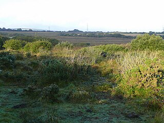
Retire Common is a Site of Special Scientific Interest, noted for its biological characteristics, in mid Cornwall, England, UK.

Devlins Creek, an urban watercourse that is part of the Parramatta River catchment, is located in Northern Suburbs region of Sydney, Australia.

Moyer Creek starts at Wheelock Pond near Jerusalem Hill, New York. Past Gulph, New York Moyer Creek follows a deep ravine, the Frankfort Gorge, south towards Frankfort, New York before converging with the Mohawk River in Frankfort, New York. The headwaters of Moyer Creek rise within a half mile of the source of the Unadilla River which is the most northerly headwater source of the Susquehanna and the closest to the Mohawk River.

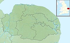
Syderstone Common is a 43.7-hectare (108-acre) biological Site of Special Scientific Interest west of Fakenham in Norfolk. An area of 24-hectare (59-acre) is managed by the Norfolk Wildlife Trust
Craig Headwaters Protected Area is a protected area located in the Stikine Region of British Columbia, Canada. It was established on January 25, 2001 to protect the Craig River Valley from the Alaskan border to its confluence with the Iskut River.