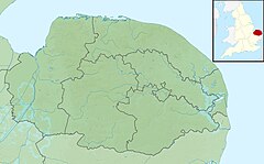
The Broads is a network of mostly navigable rivers and lakes in the English counties of Norfolk and Suffolk. Although the terms "Norfolk Broads" and "Suffolk Broads" are correctly used to identify specific areas within the two counties respectively, the whole area is frequently referred to as the Norfolk Broads.
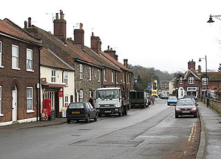
Strumpshaw is a village and civil parish in the English county of Norfolk. It is located on the northern bank of the River Yare around 6 miles (9.7 km) south-east of Norwich. The parish covers an area of 11.69 km2 (4.51 sq mi) and had a population of 602 in 245 households at the 2001 census, increasing to a population of 634 in 261 households at the 2011 Census. For the purposes of local government, it falls within the district of Broadland.

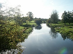
The River Yare is a river in the English county of Norfolk. In its lower reaches it is one of the principal navigable waterways of The Broads and connects with the rest of the network.

The River Chet is a small river in South Norfolk, England, a tributary of the River Yare. It rises in Poringland and flows eastwards through Alpington, Bergh Apton, Thurton and Loddon. At Loddon it passes under the A146 through Loddon Mill and into Loddon Staithe. From this point onwards the river is navigable. It then passes Hardley Flood to the north, a nature reserve part-managed by the Norfolk Wildlife Trust. The river finally joins the River Yare one mile west of Reedham at Hardley Cross, erected in 1676, which marks the ancient boundary between the City of Norwich and the Borough of Great Yarmouth. The total navigable length is some 3½ miles. Fishing is permitted between Loddon and Hardley Cross, bream and roach being the most common catch.

Gabriel Yared is a Lebanese-French composer, best known for his work in French and American cinema.
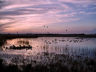
Strumpshaw Fen is a nature reserve managed by the Royal Society for the Protection of Birds (RSPB). It is situated at Strumpshaw on the River Yare in the English county of Norfolk around 6 miles (9.7 km) east of Norwich. The Buckenham Marshes RSPB reserve borders the reserve to the east.

Saint Yared was an Axumite composer in the 6th century. Often credited with the forerunner of traditional music of Ethiopia and Eritrea, he developed the religious music of Ethiopian Orthodox Church, Eritrean Orthodox Church, and the use in liturgical music, as well as the Ethiopian musical notation system. Additionally, he composed Zema, or the chant tradition of Ethiopia, particularly the chants of the Ethiopian-Eritrean Orthodox Tewahedo Churches, which are still performed today.
Lothingland is an area in the English counties of Suffolk and Norfolk on the North Sea coast. It is bound by the River Yare and Breydon Water to the north, the River Waveney to the west and Oulton Broad to the south, and includes the parts of Lowestoft north of Lake Lothing.

Postwick with Witton is a civil parish on the Broads in the English county of Norfolk, comprising the two adjacent villages of Postwick and Witton. Postwick is some 4.5 miles (7.2 km) east of the city of Norwich, just south of the eastern end of the A47 Norwich southern bypass on the north bank of the River Yare. Witton lies 1.75 miles (2.8 km) to the north-east, north of the A47.

The River Tas is a river which flows northwards through South Norfolk in England - towards Norwich. The area is named the Tas Valley after the river. The name of the river is back-formed from the name of village of Tasburgh.

Surlingham is a village and civil parish in South Norfolk situated on the Broads. It lies approximately 6½ miles south-east of Norwich on the south bank of the River Yare between Bramerton and Rockland St Mary. In the 2001 census it contained 266 households and a population of 637, increasing to 725 at the 2011 census. Although Surlingham is part of South Norfolk District, as in other broadland villages those areas of the village adjacent to the river and broads fall into the executive area of the Broads Authority.

Wherryman's Way is a long-distance footpath in the English county of Norfolk.
Trowse, also called Trowse with Newton, is a village in South Norfolk which lies about 1+1⁄2 miles (2.4 km) south-east of Norwich city centre on the banks of the River Yare. It covers an area of 4.49 km2 (1.73 sq mi) and had a population of 479 in 233 households at the 2001 census, the population increasing to 862 in 374 households at the 2011 Census. There are approved plans to build a further 770 houses on the outskirts of the village, at White Horse Lane and the Deal Ground sites.

Kimberley is a village and civil parish in the South Norfolk district, in the county of Norfolk, England, situated about 3 miles (4.8 km) north-west of Wymondham, around the crossroads of the B1108 and B1135. The parish has an area of 9.33 km2 (3.60 sq mi) and had a total population of 121 in 52 households as of the 2001 census. The parish absorbed the parish of Carleton Forehoe on the 1 April 1935.

A river mouth is the part of a river where the river debouches into a larger body of water, such as another river, a lake/reservoir, a bay/gulf, a sea, or an ocean.
Mundham is a village and civil parish in the English county of Norfolk. It covers an area of 6.31 km2 (2.44 sq mi). In 2001, the population was 168 in 63 households, and grew to 177 at the 2011 census.
Great Yarmouth Corporation Tramways served the town of Great Yarmouth in Norfolk, England from 19 June 1902 until 14 December 1933.
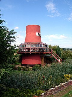
The Reedham Ferry Drainage Mill, also known as The Red Mill is a former drainage windmill found on the River Yare on The Broads in Norfolk. It is now a privately owned holiday home.

Cantley Marshes is a 272.1-hectare (672-acre) biological Site of Special Scientific Interest south-east of Norwich in Norfolk. It is managed by the Royal Society for the Protection of Birds, It is part of the Broadland Ramsar site and Special Protection Area, The Broads Special Area of Conservation and the Mid-Yare National Nature Reserve.

Toll's Meadow, Wymondham is a 1.7-hectare (4.2-acre) Local Nature Reserve in Wymondham in Norfolk. It is owned by Wymondham Town Council and managed by Wymondham Town Council and Norfolk County Council.