Hunstanton is a seaside town in Norfolk, England, which had a population of 4,229 at the 2011 Census. It faces west across The Wash, making it one of the few places on the east coast of Great Britain where the sun sets over the sea. Hunstanton lies 102 miles (164 km) north-north-east of London and 40 miles (64 km) north-west of Norwich.
The Norfolk Coast Path is a long-distance footpath in Norfolk, running 83 miles (133.5 km) from Hunstanton to Hopton-on-Sea. It was opened in 1986 and covers the North Norfolk Coast AONB.

Holme-next-the-Sea is a small village and civil parish in the English county of Norfolk. It is situated on the north Norfolk coast some 5 km north-east of the seaside resort of Hunstanton, 30 km north of the town of King's Lynn and 70 km north-west of the city of Norwich.

Wighton is a village and civil parish in the English county of Norfolk. The village is situated some 6 km (3.7 mi) south of the town of Wells-next-the-Sea, 12 km (7.5 mi) north of the town of Fakenham, and 45 km (28 mi) north-west of the city of Norwich. The medieval pilgrimage centre of Walsingham lies 3 km (1.9 mi) to the south.

Heacham was a railway station which served the seaside resort of Heacham in Norfolk, England. Opened in 1862, the station became a junction where services left the King's Lynn to Hunstanton line for Wells on the West Norfolk Junction Railway, which opened in 1866. The station closed with the Hunstanton line in 1969.

The A149 is commonly known as "The Coast Road" to local residents and tourists as this road runs along the North Norfolk coast from King's Lynn to Cromer passing through small coastal villages. The road then leaves the coastline at Cromer and reaches the Norfolk Broads.
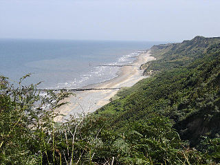
The Norfolk Coast Area of Outstanding Natural Beauty is a protected landscape in Norfolk, England. It covers over 450 km2 of coastal and agricultural land from The Wash in the west through coastal marshes and cliffs to the sand dunes at Winterton in the east. It was designated AONB in 1968, under the National Parks and Access to the Countryside Act 1949.
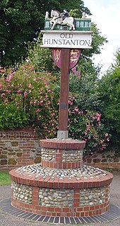
Old Hunstanton is a village and civil parish in the English county of Norfolk. It covers an area of 5.35 km2 (2.07 sq mi) and had a population of 47 in 25 households at the 2001 census. The population had risen to 628 at the 2011 Census. For the purposes of local government, it falls within the district of King's Lynn and West Norfolk.
Wells-next-the-Sea railway station served the port town of Wells-next-the-Sea in North Norfolk, England. It was opened in 1857 by the Wells & Fakenham Railway, later part of the Great Eastern Railway's Wymondham to Wells branch, and became a junction in 1866 with the arrival of the West Norfolk Junction Railway. It closed in 1964.
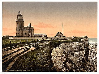
Old Hunstanton Lighthouse is a former lighthouse located in Old Hunstanton in the English county of Norfolk, generally called Hunstanton Lighthouse during its operational life. It was built at the highest point available on this part of the coast, on top of Hunstanton Cliffs, and served to help guide vessels into the safe water of Lynn Deeps. Although the present lighthouse was built in 1840, there had been a lighthouse on the site since the 17th century. Prior to the establishment of the Lynn Well light vessel in 1828, Hunstanton Lighthouse provided the only visible guide to ships seeking to enter The Wash at night.
Holkham was a railway station which served the coastal village of Holkham in Norfolk, England. Opened by the West Norfolk Junction railway in 1866, it closed with the line in 1952.
Burnham Market was a railway station which served the village of Burnham Market in Norfolk, England. Opened by the West Norfolk Junction railway in 1866, it closed with the line in 1952.

Stanhoe was a railway station which served the village of Stanhoe in Norfolk, England. Opened by the West Norfolk Junction Railway in 1866, it closed to passengers in 1952.

Sedgeford was a railway station which served the settlement of Sedgeford in Norfolk, England. Opened by the West Norfolk Junction Railway in 1866, passenger services ceased with the line in 1952.
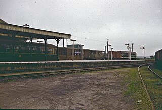
Hunstanton railway station served the seaside town of Hunstanton in Norfolk, England. Opened in 1862, the station was the northern terminus of the Lynn and Hunstanton Railway. The line was brought to public notice by John Betjeman in the British Transport Film John Betjeman Goes By Train. The station closed with the line in 1969.
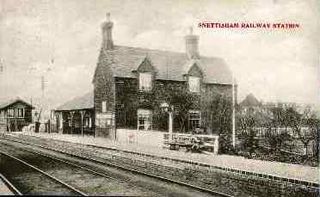
Snettisham was a railway station on the King's Lynn to Hunstanton line which served the village of Snettisham, a few miles north of King's Lynn in North Norfolk, England. Opened in 1862, the station closed along with the line in 1969.

Dersingham was a railway station on the King's Lynn to Hunstanton line which served the village of Dersingham, a few miles north of King's Lynn in North Norfolk, England.
The West Norfolk Junction Railway was a standard gauge eighteen and a half-mile single-track railway running between Wells-next-the-Sea railway station and Heacham in the English county of Norfolk. It opened in 1866 and closed in 1953. At Wells the line made a junction with the Wells and Fakenham Railway and at Heacham it connected with the line from Hunstanton to Kings Lynn.

Hunstanton Lifeboat Station is a Royal National Lifeboat Institution operated lifeboat station located in the village of Old Hunstanton in the English county of Norfolk. This is the only lifeboat station on the east coast of England which faces westward, being positioned on the east side of the square-mouthed bay and estuary known as The Wash.

The Lynn and Hunstanton Railway was a line in Norfolk, England that opened in 1862. The railway was a major factor in developing Hunstanton as a seaside resort and residential community. The company was allied to the West Norfolk Junction Railway which built a line connecting Heacham, south of Hunstanton, to Wells-next-the-Sea that was not a financial success. The companies amalgamated in 1874 to form the Hunstanton and West Norfolk Railway, and in 1890 the company was sold to the Great Eastern Railway.